


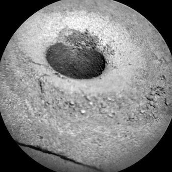
 Sol 1140, October 20, 2015, update from USGS scientist Ken Herkenhoff: The ChemCam RMI images of the drill hole planned yesterday were successfully acquired and received, and were used today to plan 2 parallel LIBS rasters down the hole. The additional LIBS raster should be useful in measuring variations in chemistry among individual sand grains and in detecting thin veins. ChemCam and Mastcam will also observe a target dubbed “Marshall” to see whether silica enrichment extends along other fractures… [More at link]
-
Recent Posts
Tags
Aeolis Mons Arizona State University ASU atmosphere Beautiful Mars Cape Tribulation clouds craters Curiosity dunes dust Endeavour Crater ESA European Space Agency Gale Crater High Resolution Imaging Science Experiment HiRISE Malin Space Science Systems Marathon Valley MARCI Mars Color Imager Mars Exploration Rover Mars Odyssey Mars Reconnaissance Orbiter Mars Science Laboratory mass wasting MER Mount Sharp MRO MSL MSSS Murray Formation NASA Opportunity sand dunes Stimson Formation storms THEMIS THEMIS Image of the Day Thermal Emission Imaging System University of Arizona Vera Rubin Ridge volcanics weather windArchives
Links
general
mission instruments
- CRISM: Compact Reconnaissance Imaging Spectrometer for Mars
- CTX: Context Camera
- HiRISE: High Resolution Imaging Science Experiment
- MARSIS: Mars Advanced Radar for Subsurface and Ionosphere Sounding
- SHARAD: Shallow Radar
- THEMIS: Thermal Emission Imaging System
missions
- All Mars missions list
- Curiosity rover
- ExoMars
- Hope (al-Amal) orbiter
- InSight
- Mars Atmosphere and Volatile Evolution Mission (MAVEN)
- Mars Exploration Rovers (MER)
- Mars Express (MEX)
- Mars Odyssey
- Mars Orbiter Mission (MOM) / Mangalyaan
- Mars Reconnaissance Orbiter (MRO)
- Mars Science Laboratory (MSL)
- Perseverance Rover
- Tianwen-1 orbiter/rover
news