


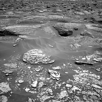
 Sol 1707-08, May 25, 2017, update by MSL scientist Michael Battalio: After a 14.6 m drive, the GEO group decided against arm activities due to a lack of compelling targets and in deference to making the next drive longer. Thusly, GEO science activities relied on Mastcam and ChemCam. On Sol 1707, ChemCam will capture a raster of the “White Cap Mountain” bedrock target (the white bedrock left of center in the bottom quarter of the above Navcam image), as well as a patch of dark undisturbed soil called “French Hill Pond.” Mastcam will document all of the ChemCam targets and will image “Googings Ledge” (the large, darker bedrock just above and right of image center) and “The Twinnies” (the shadowed bedrock exposure cut off on the far left), which are sedimentary members of the Murray formation, and… [More at link]
-
Recent Posts
Tags
Aeolis Mons Arizona State University ASU atmosphere Beautiful Mars Cape Tribulation clouds craters Curiosity dunes dust Endeavour Crater ESA European Space Agency Gale Crater High Resolution Imaging Science Experiment HiRISE Malin Space Science Systems Marathon Valley MARCI Mars Color Imager Mars Exploration Rover Mars Odyssey Mars Reconnaissance Orbiter Mars Science Laboratory mass wasting MER Mount Sharp MRO MSL MSSS Murray Formation NASA Opportunity sand dunes Stimson Formation storms THEMIS THEMIS Image of the Day Thermal Emission Imaging System University of Arizona Vera Rubin Ridge volcanics weather windArchives
Links
general
mission instruments
- CRISM: Compact Reconnaissance Imaging Spectrometer for Mars
- CTX: Context Camera
- HiRISE: High Resolution Imaging Science Experiment
- MARSIS: Mars Advanced Radar for Subsurface and Ionosphere Sounding
- SHARAD: Shallow Radar
- THEMIS: Thermal Emission Imaging System
missions
- All Mars missions list
- Curiosity rover
- ExoMars
- Hope (al-Amal) orbiter
- InSight
- Mars Atmosphere and Volatile Evolution Mission (MAVEN)
- Mars Exploration Rovers (MER)
- Mars Express (MEX)
- Mars Odyssey
- Mars Orbiter Mission (MOM) / Mangalyaan
- Mars Reconnaissance Orbiter (MRO)
- Mars Science Laboratory (MSL)
- Perseverance Rover
- Tianwen-1 orbiter/rover
news