THEMIS: False colors on Terra Sirenum plains

Terra Sirenum plains and craters (THEMIS_IOTD_20170525)THEMIS Image of the Day, May 25, 2017. Today’s false color image shows part of the plains and craters in Terra Sirenum.

The THEMIS VIS camera contains 5 filters. The data from different filters can be combined in multiple ways to create a false color image. These false color images may reveal subtle variations of the surface not easily identified in a single band image.

More THEMIS Images of the Day by geological topic.

Posted in Reports | Tagged , , , , , , , , | Comments Off

Curiosity update: when Mars gives you lemons, calibrate your instruments

NLB_548858612EDR_F0631636NCAM00277M_-br2Sol 1707-08, May 25, 2017, update by MSL scientist Michael Battalio: After a 14.6 m drive, the GEO group decided against arm activities due to a lack of compelling targets and in deference to making the next drive longer. Thusly, GEO science activities relied on Mastcam and ChemCam. On Sol 1707, ChemCam will capture a raster of the “White Cap Mountain” bedrock target (the white bedrock left of center in the bottom quarter of the above Navcam image), as well as a patch of dark undisturbed soil called “French Hill Pond.” Mastcam will document all of the ChemCam targets and will image “Googings Ledge” (the large, darker bedrock just above and right of image center) and “The Twinnies” (the shadowed bedrock exposure cut off on the far left), which are sedimentary members of the Murray formation, and… [More at link]

Posted in Reports | Tagged , , , , , , , , , , , , | Comments Off

HiRISE: Oblique view of uplifted rocks

ESP_021545_1660This image shows part of the central uplifted region of an impact crater more than 50 kilometers wide. That means that the bedrock has been raised from a depth of about 5 kilometers, exposing ancient materials.

The warm (yellowish-reddish) colors mark the presence of minerals altered by water, whereas the bluish and greenish rocks have escaped alteration. Sharp-crested ridges and smooth areas are young windblown materials. [More at link]

Posted in Reports | Tagged , , , , , , | Comments Off

MARCI weather report, May 15-21, 2017

May-17-2017For the past week on Mars, arcuate-shaped dust storms and water-ice clouds continued to propagate eastward along the northern seasonal ice cap edge. A few transient dust storms were spotted over Utopia Planitia associated with polar activity. Looking to the southern highlands, local-scale dust storms repeatedly swept over southern Aonia and south of Argyre, sending dust hazes east, past Promethei. Diffuse water-ice clouds…  [More at link, including video]

Posted in Reports | Tagged , , , , , , , , , , , , , | Comments Off

Curiosity: Onward through the speedbumps

1705-navcamCuriosity_Location_Sol1705Sol 1705, May 24, 2017. Navcam shows the way through a field of rounded sedimentary rocks like eroded speedbumps. At right, the arrow points to Curiosity’s position on the approach to Vera Rubin Ridge (bottom). Click images to enlarge them.

Sol 1705 raw images (from all cameras), and Curiosity’s latest location.

Posted in Reports | Tagged , , , , , , , , | Comments Off

Schiaparelli crash investigation finishes

ESA ExoMars 2016The inquiry into the crash-landing of the ExoMars Schiaparelli module has concluded that conflicting information in the onboard computer caused the descent sequence to end prematurely.

The Schiaparelli entry, descent and landing demonstrator module separated from its mothership, the Trace Gas Orbiter, as planned on 16 October last year, and coasted towards Mars for three days.

Much of the six-minute descent on 19 October went as expected: the module entered the atmosphere correctly, with the heatshield protecting it at supersonic speeds. Sensors on the front and back shields collected useful scientific and engineering data on the atmosphere and heatshield. (…)

The report summary can be downloaded here.  [More at links]

Posted in Reports | Tagged , , , , , , , | Comments Off

THEMIS: Plains of Terra Cimmeria in false color

Terra Cimmera plains (THEMIS_IOTD_20170524)THEMIS Image of the Day, May 24, 2017. Today’s false color image shows part of the plains of Terra Cimmeria.

The THEMIS VIS camera contains 5 filters. The data from different filters can be combined in multiple ways to create a false color image. These false color images may reveal subtle variations of the surface not easily identified in a single band image.

More THEMIS Images of the Day by geological topic.

Posted in Reports | Tagged , , , , , , , , | Comments Off

HiRISE: Ongoing dune activity in Ganges Chasma

tumblr_oq1x00XzMF1rlz4gso1_1280Ongoing dune activity in Ganges Chasma. Beautiful Mars series.

Posted in Reports | Tagged , , , , , , , , , , | Comments Off

HiRISE: Dune ripples in Her Desher Vallis

ESP_020562_1550These small ripples, about 10 meters apart, are located in Her Desher Vallis. Her Desher is a small channel that shows evidence of phyllosilicates—silicates with a sheet-like structure, such as clay minerals.

Much larger images of this area show that Her Desher Vallis appears isolated, with no obvious connections to craters or larger valleys. Her Desher, the ancient Egyptian name for Mars, translates to “the Red One.”

Posted in Reports | Tagged , , , , , , , , | Comments Off

Curiosity update: Rocky road

FLB_548677354EDR_F0631450FHAZ00302M_-br2
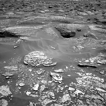
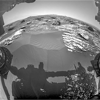
Sol 1705-06, May 22, 2017, update by MSL scientist Abigail Fraeman: Curiosity is continuing to make progress towards Vera Rubin Ridge along the Mt Sharp ascent route.  We planned two sols today, Sol 1705 and Sol 1706.  On our first sol, we will kick off the day with some remote sensing science on the bedrock in front of us, including ChemCam observations of targets “Turtle Island”, “Stony Brook”, and “Dike Peak”.  Turtle Island is typical Murray bedrock, Stony Brook has an interesting dark streak running through it, and Dike Peak is a neat looking block with dark colored fracture fills.  We will complement these observations with Mastcam documentation imaging.  We’ll then go for a short drive and take some post drive imaging and a ChemCam AEGIS observation.  On the second sol of the plan, Curiosity will be focused on taking atmospheric observations, including a dust devil search and images of the crater rim and sky above us.

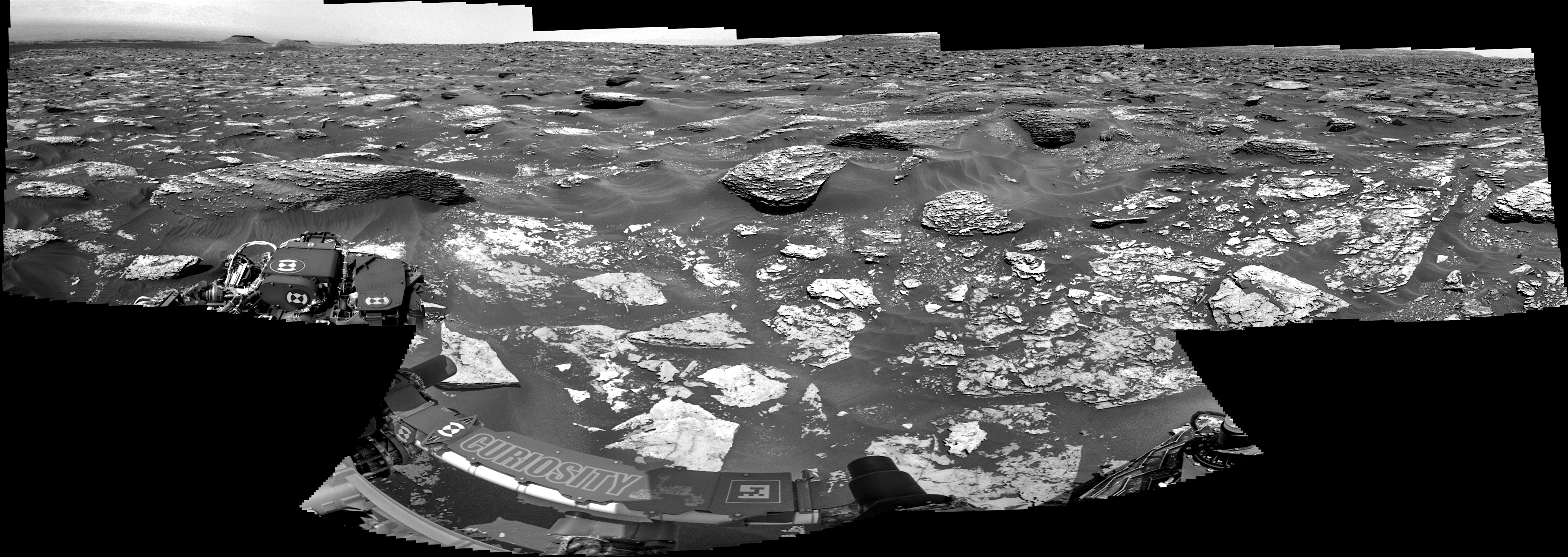
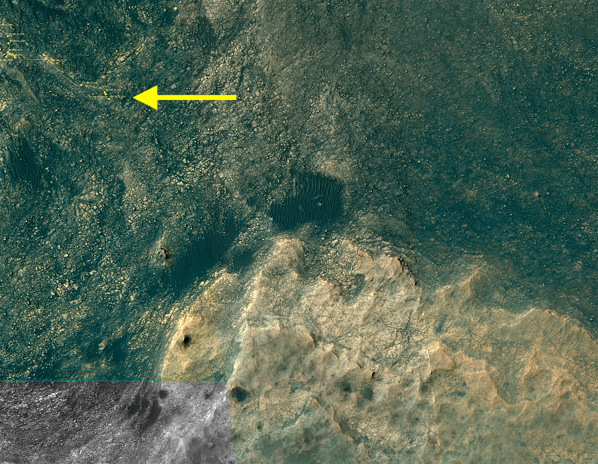
We didn’t drive as far as we thought we would over the weekend.  Software onboard Curiosity sensed the rover was struggling to travel over the challenging terrain more than we had anticipated… [More at link]
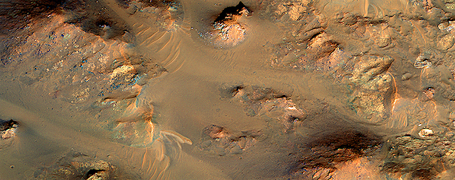
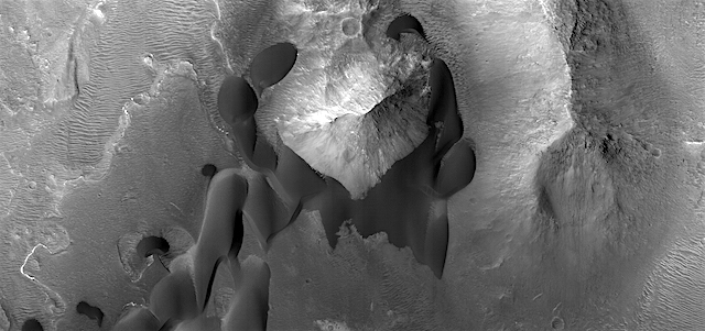
Posted in Reports | Tagged , , , , , , , , , , | Comments Off