Curiosity: Getting to Pahrump

746-look-ahead2
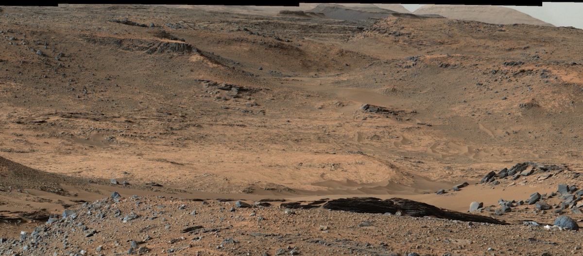
Sol 746, September 11, 2014. With Curiosity parked at the west end of Jubilee Pass, the Navcam takes in the probable route downward toward the Pahrump Hills in the distance (three-frame Navcam composite).

Sol 746 raw images (from all cameras), and Curiosity’s latest location map.

Posted in Reports | Tagged , , , , , , , , , , | Comments Off

HiRISE: Overlapping lava flows in Daedalia Planum

ESP_037641_1560Lava flows south of Arsia Mons in Daedalia Planum transition from younger flows with elongated, sinuous morphologies to the northeast, to older, broader lobes and sheet flows to the southwest. (The time scale we’re talking about is approximately 100 million to 1 billion years.)… [More at link]

Posted in Reports | Tagged , , , , , , , , , | Comments Off

Opportunity: Ejecta rock collection in color

1P463579336ESFCHJ3P2388L5M1_L2L5L5L7L7Sol 3778, September 9, 2014. The Pancam made close-up views of several of the rocks lying near the rover, which were probably thrown out by the Ullysses Crater impact (see previous post).  These false-color images were created by Holger Isenberg using filtered Pancam frames.

1P463579599ESFCHJ3P2582L5M1_L2L5L5L7L7Opportunity raw images, its latest mission status, and a location map. (A shortcut to Sol 3778 Pancam raw images is here.)

Posted in Reports | Tagged , , , , , , , , , | Comments Off

Opportunity: Ejecta from Ulysses Crater

3778-ulysses-ejectaSol 3778, September 9, 2014. Sharp-edged rocks lie scattered across the ground near Opportunity. These rocks were likely ejected by the meteorite impact that blasted Ulysses Crater, which sits at the southwest end of Wdowiak Ridge. The lower parts of Ulysses form the “bump” on the skyline at top left in this two-frame Navcam composite.

Opportunity raw images, its latest mission status, and a location map. (A shortcut to Sol 3778 Navcam raw images is here.)

Posted in Reports | Tagged , , , , , , , , | Comments Off

HiRISE: Mars – or a Petri dish?

tumblr_nbpf16cRhL1rlz4gso1_1280Mars — or a Petri dish? Beautiful Mars series.

Posted in Reports | Tagged , , , , , , , , , | Comments Off

New Curiosity science plan: ‘Drive less, drill more’

Pahrump HillsNASA’s Mars Curiosity Rover Arrives at Martian Mountain

NASA’s Mars Curiosity rover has reached the Red Planet’s Mount Sharp, a Mount-Rainier-size mountain at the center of the vast Gale Crater and the rover mission’s long-term prime destination… Curiosity’s trek up the mountain will begin with an examination of the mountain’s lower slopes. The rover is starting this process at an entry point near an outcrop called Pahrump Hills, rather than continuing on to the previously-planned, further entry point known as Murray Buttes… [More at link]

Curiosity’s Extended Mission 1 Science Plan (PDF, 11 MB)

Posted in Reports | Tagged , , , , , , , , | Comments Off

HiRISE: Chaos in Eridania Basin

ESP_037142_1430Eridania is the name of topographically enclosed basin located in the Southern highlands of Mars that has been suggested to be the site of a large ancient lake or inland sea. A chaotic jumble of relatively bright blocks sits on the lowest floor regions of the basin, sampled in… [More at link]

Posted in Reports | Tagged , , , , , , , | Comments Off

THEMIS: Pavonis Mons

Rough terrain on Pavonis Mons (THEMIS_IOTD_20140911)THEMIS Image of the Day, September 11, 2014. Today’s VIS image shows part of the western flank of Pavonis Mons.

More THEMIS Images of the Day by geological topic.

Posted in Reports | Tagged , , , , , , , , , | Comments Off

Curiosity update: ‘NASA teleconference’

Sol 746, September 10, 2014, update from USGS Scientist Ken Herkenhoff: “The Sol 744 drive went as planned (32 meters), and another drive is planned for Sol 746.  Because we can’t see the terrain immediately beyond the small saddle…” [More at link]

Posted in Reports | Tagged , , , , , , , , , | Comments Off

Opportunity: Rock and soil in color

1P463405012EFFCHJ3P2581L5M1_L2L5L5L7L7Sol 3776, September 7, 2014. Rock (and fragments), soil, and a wheel track, as seen in a false-color image assembled by Holger Isenberg using filtered Pancam frames. The color differences between parts of the rock suggest that the rover’s wheel cracked the rock open, revealing fresh and undusted surfaces.

Opportunity raw images, its latest mission status, and a location map. (A shortcut to Sol 3776 Pancam raw images is here.)

Posted in Reports | Tagged , , , , , , | Comments Off