HiRISE: Ancient lake sediments

ESP_037122_2165
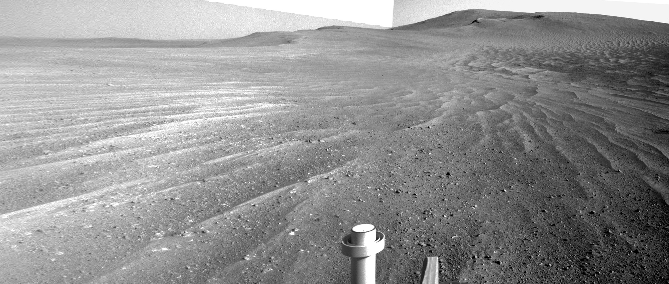
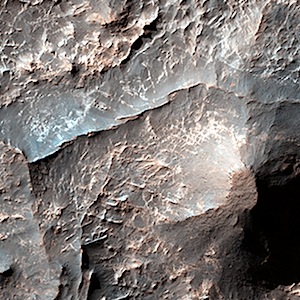
This image shows some interesting fractured materials on the floor of an impact crater in Arabia Terra. There is a channel entering the crater and exiting it (see CTX image). This channel, along with an unusual deposit on the lowest part of the floor, suggests that there was once an ancient lake that deposited sediments here… [More at link]

Posted in Reports | Tagged , , , , , , , , , | Comments Off

Curiosity: Sol 694, July 20, 2014

0694ML0029340010304127E01_DXXXSharp, wind-scoured basalt rocks lie thick on Zabriskie Plateau, which Curiosity is crossing (wide-angle Mastcam image).

NASA description: This image was taken by Mastcam: Left (MAST_LEFT) onboard NASA’s Mars rover Curiosity on Sol 694 (2014-07-20 03:26:39 UTC).

Sol 694 raw images (from all cameras), and Curiosity’s latest location map.

Posted in Reports | Tagged , , , , , | Comments Off

Curiosity update: ‘South Park’

Sols 693-695, July 18-20, 2014, update on Curiosity from USGS scientist Ken Herkenhoff: “There isn’t time today to plan 3 sols of activities before commands for Sol 693 must be sent to the rover, so no activities are being planned….” [More at link]

Posted in Reports | Tagged , , , , , | Comments Off

Opportunity: Sol 3728, July 20, 2014

saddle-pan2Sand ripples trace roughly parallel lines across the saddle between the Solander Point rim segment, which Opportunity has explored, and the Cape Tribulation segment lying ahead on the skyline (two-frame Navcam composite).

Opportunity raw images, its latest mission status, and a location map. (A shortcut to Sol 3728 Navcam images is here.)

Posted in Reports | Tagged , , , , , , , , | Comments Off

HiRISE: Icy surface of the north polar cap

ESP_036867_2655At Mars’ north pole is a dome of icy layers ranging up to 2 kilometers thick, roughly analogous to the Earth’s ice caps in Greenland or Antarctica. Although not visible here, the dome is characterized by incised spiraling troughs that reveal sequences of layers thought to reflect varying climate conditions over the time they were originally deposited. This image is of an area on the top surface of the polar dome between the troughs — vast, generally smooth, flat plains composed of a thin layer of very pure water ice….. [More at link]

Posted in Reports | Tagged , , , , , , , | Comments Off

HiRISE: Ridges in Eridania basin

ESP_036654_1490Eridania Basin, located at the head of Ma’adim Vallis, has mounting geomorphic and spectral evidence that it may have been the site of an ancient inland sea. This site presents interesting mineralogical and geological evidence for the past existence of a large aqueous system on Mars that could have been long lived, and may have been well suited for ancient life, and almost certainly contains important clues about the ancient climate… [More at link]

Posted in Reports | Tagged , , , , , , , , | Comments Off

Curiosity: ‘This is awful stuff’

FRB_459095389EDR_F0391176FHAZ00323M_After travelling 8.5 kilometers on Mars, NASA’s Curiosity rover is now facing some of the most dangerous terrain it has ever encountered…. Winds at Gale Crater, Curiosity’s landing site, have whittled and sharpened rocks into piercing points unlike that seen by NASA’s three earlier Mars rovers. Curiosity needs to travel about 200 metres of this sharp ‘caprock’ before it can descend into a sandy, more wheel-friendly depression dubbed Hidden Valley.

“This is awful stuff,” says John Grotzinger, the mission’s chief scientist and a geologist at the California Institute of Technology (Caltech) in Pasadena…. [More at link]

Posted in Reports | Tagged , , , , , , , | Comments Off

THEMIS: More polar dunes

Polar dunes swarm around hills (THEMIS_IOTD_20140721)THEMIS Image of the Day, July 21, 2014. This VIS image shows part of the large dune field called Olympia Undae. There are hills in this region, and the dunes are concentrated in the lower elevations.

More THEMIS Images of the Day by geological topic.

Posted in Reports | Tagged , , , , , , , , , , | Comments Off

New global Mars geologic map

USGS-geol-mapThis global geologic map of Mars, which records the distribution of geologic units and landforms on the planet’s surface through time, is based on unprecedented variety, quality, and quantity of remotely sensed data acquired since the Viking Orbiters. These data have provided morphologic, topographic, spectral, thermophysical, radar sounding, and other observations for integration, analysis, and interpretation in support of geologic mapping. In particular, the precise topographic mapping now available has enabled consistent morphologic portrayal of the surface for global mapping (whereas previously used visual-range image bases were less effective, because they combined morphologic and albedo information and, locally, atmospheric haze). Also, thermal infrared image bases used for this map tended to be less affected by atmospheric haze and thus are reliable for analysis of surface morphology and texture at even higher resolution than the topographic products.

Posted in Reports | Tagged , , | Comments Off

Curiosity update: ‘Bizarre environment’

Sol 692, July 18, 2014, update on Curiosity from USGS scientist Ken Herkenhoff: “Another good day at the International Mars Conference, with back-to-back talks by USGS Astrogeologists: First, Colin Dundas showed evidence….” [More at link]

Posted in Reports | Tagged , , , , | Comments Off