


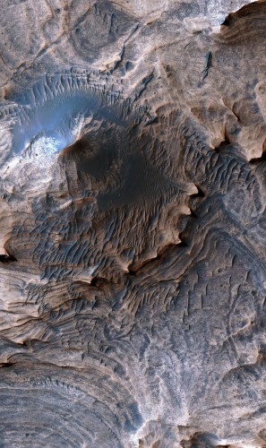
 The U.S. Geological Survey released its highest-resolution geologic map of Mars today, and it is the most detailed representation of the Red Planet to date…. This new map provides geologic and structural information on layered sedimentary rocks at a scale comparable to what a field geologist would see on Earth, including a precise illustration of a portion of the “Grand Canyon of Mars,” or Valles Marineris…. The new geologic and structural map uses the highest-resolution, orbiter-based images currently available for Mars…. The area analyzed, called western Candor Chasma, is one of the largest canyons in the Valles Marineris canyon system. The resulting map provides the most detailed information of the geology of Mars at a human scale over a broad area of terrain, and is available for download online… [More at links]
-
Recent Posts
Archives
Links
general
mission instruments
- CRISM: Compact Reconnaissance Imaging Spectrometer for Mars
- CTX: Context Camera
- HiRISE: High Resolution Imaging Science Experiment
- MARSIS: Mars Advanced Radar for Subsurface and Ionosphere Sounding
- SHARAD: Shallow Radar
- THEMIS: Thermal Emission Imaging System
missions
- All Mars missions list
- Curiosity rover
- ExoMars
- Hope (al-Amal) orbiter
- InSight
- Mars Atmosphere and Volatile Evolution Mission (MAVEN)
- Mars Exploration Rovers (MER)
- Mars Express (MEX)
- Mars Odyssey
- Mars Orbiter Mission (MOM) / Mangalyaan
- Mars Reconnaissance Orbiter (MRO)
- Mars Science Laboratory (MSL)
- Perseverance Rover
- Tianwen-1 orbiter/rover
news