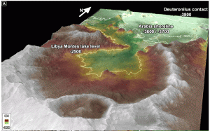
New work suggests that three possible shorelines from ancient lakes or seas in Isidis Planitia lie in Libya Montes.

SHORELINES? Distinct levels which may represent ancient shorelines appear in central Libya Montes. Possible coastal cliffs appear at –3600 and –3700 meters, indicating two distinct surface levels for bodies of water. Elevations are in meters relative to the mean radius of Mars. (Image taken from Figure 4 in the paper.)
These mountains form the southern rim of Isidis, a Noachian-age impact basin 1,225 kilometers (760 miles) in diameter. They lie along the highland/lowland boundary and consist mainly of mountainous massifs and ridges, mixed with remnants of impact craters. In numerous places the montes show evidence of flowing water: fluvial channels, deltas, and alluvial fan deposits.
Now a team of scientists led by Gino Erkeling (University of Münster) is proposing that they have identified old shorelines or sea cliffs in Libya Montes. If true, these strengthen the case for possible sea-scale standing bodies of water in the Isidis basin and other depressions on Mars in the past. The new work appears in a recent paper in Icarus.
“At the Libya Montes/Isidis Planitia boundary, we identified landforms at three different elevation levels,” says the team. “The landscape features show evidence of intense fluvial activity, standing bodies of water, alteration by water, wave-cut action, and distinct water levels caused by freezing and sublimation of a cold ocean.”
In an unnamed crater 60 kilometers (45 miles) wide, the team found the first features at elevations between –2500 and –2800 meters relative to the Martian datum. They include valleys, terraces, delta deposits with hydrated minerals, and an outlet in the crater rim. These all point to a standing body of water in the crater, say the scientists.
About one kilometer (3,300 ft) lower lie shoreline features consisting of cliffs and terraces. The researchers write, “Most conspicuous are a series of candidate coastal cliffs of the Arabia shoreline that coincide with the –3700 meter elevation.” The cliff landforms possibly resemble terrestrial sea cliffs eroded by wave-cut action and could have formed during sea-level variations of an Isidis sea.
The lowest feature the scientists identify is the –3800 meter Deuteronilus contact. It is likely the result of standing water — or an ice sheet — that filled the northern lowlands of Mars.
The landscape features are consistent, the team says, with a global change in climate from warm and wet conditions to cold and dry ones.
“Because the possible shorelines appear close to each other in the Libya Montes,” they say, “we propose this site as a new candidate landing site for potential future missions after MSL Curiosity.”


