Located west of the big Hellas impact basin in Mars’ southern hemisphere, Russell Crater spreads 135 kilometers (84 miles) wide. A notable feature within it is a broad dune field with a “megadune” heaped up toward the east. The megadune rises about 500 meters (1,600 feet) high and the dune field extends 40 km (25 mi) long. It appears to have been built by winds blowing from the northeast.

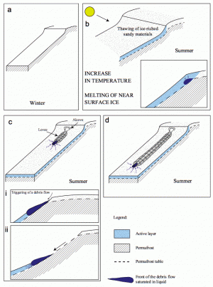
FLOW AND GO. A warm surface layer on a permanently frozen dune could produce the leveed channels and gullies seen on the Russell Crater megadune. As debris flows descended, their most heavily water-saturated parts led the way down the slope. When the flow ceased, the water evaporated (or sank into the dune), leaving only a small terminal "bump" of debris at the gully's end. (Image taken from Figure 9 in the paper.)
What makes the Russell megadune interesting are approximately 300 long and narrow gullies that have formed on it. Running straight downslope for about 2 kilometers (1.2 mi) and largely parallel, these were the focus of research by a team of geologists led by Gwenaël Jouannic (Université Paris-Sud). Reporting in Planetary and Space Science (July 14, 2012), the scientists write, “The presence of gullies on Martian dunes is rare, and the processes, as well as the origin of the fluid necessary for their formation, currently remain poorly understood.”
Detailed mages from orbit using the HiRISE camera on NASA’s Mars Reconnaissance Orbiter show that the gullies are not simply ditches running down the dune’s slopes. Instead, the gully channels have elevated levees along their edges. In addition, most of them lack a pileup of debris, as might be expected at the downslope end of the gully.
Looking at terrestrial examples, the geologists found that debris flows offered the best analog. “Debris flows on Earth consist of a mixture of solid detritus with a significant proportion of liquid water moving under gravity in a state of general flow.” Flows normally start on slopes exceeding 10° and once moving, they can flow on slopes of 1° to 2°.
“On Mars,” the team explains, “the Mars Exploration Rovers determined a regolith friction angle (very fine sand) ranging from 30° to 37°. On the Russell Crater dune, only a small area located under the dune crest presents a slope higher than 25°. It would be difficult for dry granular flows to slide more than 2 km on such a low slope.”
The levees flanking the gullies led the team to examine wet debris flows rather than dry flows. To erode a single typical Russell Crater gully, they calculated that water would have to make up at least 30 to 40 percent of the flow’s volume. Given the average size of each gully, this amounts to “the volume of water contained in about two or three Olympic swimming pools.” Thus some 600 to 900 Olympic pools would be needed to form all the gullies observed on the Russell megadune.
Sand dunes are highly porous, so the next question the team tackled was how to keep water flowing at the dune surface while not sinking deep into the dune. The answer, they decided, was permafrost. The dune remains wholly frozen during winter, but the upper meter or two thaws during summer. It is this layer that water can move downslope.
Complicating the picture is the fact that the Russell gullies reflect two stages of development. “The Russell megadune is well known to be influenced by seasonal flow activities during the past three years due to the presence of CO2 ice and H2O ice. Consequently, the Russell crater dune morphologies are a superimposition of present flow activities and older erosion features.”
They explain that this recent seasonal activity generates numerous small interconnected and sinuous rills, making a pattern shorter and narrower than the gullies. The presence of bedforms within the older channel also indicates the wind is blowing fine particles on the dune in the recent past.
Present-day temperatures in Russell Crater in early spring are so cold that only a limited melting of water ice can occur. However, calculations of Martian climate change suggest that an active dune layer was possible about 5 to 10 million years ago. In addition, snow melt could be a possible secondary source of water for eroding the gullies.
“In such conditions,” say the scientists, “the formation of debris flows by melting of near-surface ground ice was possible in some favored areas.”


Pingback: Did Mars Have Water? : Telescopes and astronomy for everyone