


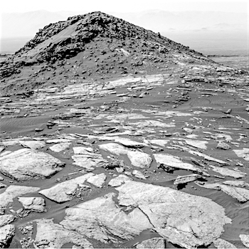
 Sol 1598-99 January 30, 2017, update by USGS scientist Lauren Edgar: The drive on Sol 1598 went well, and Curiosity drove ~21 m to the southwest, providing a great view of “Ireson Hill,” seen in the above Navcam image. Today’s two-sol plan looks pretty similar to the last. We’ll start with MAHLI and APXS of the target “Digdeguah” to investigate typical local bedrock with some exposed stratification. Then ChemCam will continue its recovery activities with an RMI observation of the titanium calibration target. We’ll use Mastcam to acquire a large mosaic of “Ireson Hill” to characterize the contact and color variations exposed on the south side of this feature. [More at link]
-
Recent Posts
Archives
Links
general
mission instruments
- CRISM: Compact Reconnaissance Imaging Spectrometer for Mars
- CTX: Context Camera
- HiRISE: High Resolution Imaging Science Experiment
- MARSIS: Mars Advanced Radar for Subsurface and Ionosphere Sounding
- SHARAD: Shallow Radar
- THEMIS: Thermal Emission Imaging System
missions
- All Mars missions list
- Curiosity rover
- ExoMars
- Hope (al-Amal) orbiter
- InSight
- Mars Atmosphere and Volatile Evolution Mission (MAVEN)
- Mars Exploration Rovers (MER)
- Mars Express (MEX)
- Mars Odyssey
- Mars Orbiter Mission (MOM) / Mangalyaan
- Mars Reconnaissance Orbiter (MRO)
- Mars Science Laboratory (MSL)
- Perseverance Rover
- Tianwen-1 orbiter/rover
news