


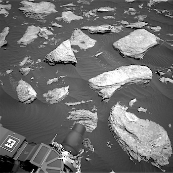
 Sol 1612-13, February 16, 2017, update by USGS scientist Ken Herkenhoff: After a 23-meter drive on Sol 1611, MSL again ended up in an area with many bedrock blocks partly covered by dark sand. We’re planning two sols today to get a head start on planning for the holiday weekend, with the first sol strategically planned to allow the “touch and go” option. But there’s a ridge about 30 meters ahead that we can’t see over, and we would like to be able to drive up onto it on Sol 1612 to allow a drive past it to be planned this weekend. There isn’t enough time before the “decisional” telecommunications opportunity to fit both contact science and a 30-meter drive into the plan, so we had to pick one of these two options. Based on images taken from orbit and by the rover, lots of bedrock is exposed at the crest of the ridge 30 meters away, so we picked the longer drive at the expense of contact science today, hoping that… [More at link]
-
Recent Posts
Archives
Links
general
mission instruments
- CRISM: Compact Reconnaissance Imaging Spectrometer for Mars
- CTX: Context Camera
- HiRISE: High Resolution Imaging Science Experiment
- MARSIS: Mars Advanced Radar for Subsurface and Ionosphere Sounding
- SHARAD: Shallow Radar
- THEMIS: Thermal Emission Imaging System
missions
- All Mars missions list
- Curiosity rover
- ExoMars
- Hope (al-Amal) orbiter
- InSight
- Mars Atmosphere and Volatile Evolution Mission (MAVEN)
- Mars Exploration Rovers (MER)
- Mars Express (MEX)
- Mars Odyssey
- Mars Orbiter Mission (MOM) / Mangalyaan
- Mars Reconnaissance Orbiter (MRO)
- Mars Science Laboratory (MSL)
- Perseverance Rover
- Tianwen-1 orbiter/rover
news