


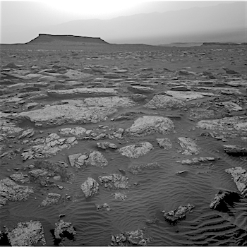
 Sol 1661-63, April 8, 2017, update by USGS scientist Ryan Anderson: Our drive away from the “Ogunquit Beach” sand dune location went well, taking us about 35 meters to the southwest and putting us in a good location to continue measuring the composition of the bedrock as we drive up Mt. Sharp. The Sol 1661 plan starts out with a Mastcam mosaic of “Old Speck Mountain” and some Navcam cloud detection observations. ChemCam will then analyze the targets “Blueberry Mountain,” “Brewer Mountain,” and “Mud Hole” with Mastcam documentation images for each target. I also requested some long distance ChemCam images of a cliff face on Mt. Sharp. I wasn’t able to participate in planning today, so we will see if the instructions I left the uplink team were correct! [More at link]
-
Recent Posts
Archives
Links
general
mission instruments
- CRISM: Compact Reconnaissance Imaging Spectrometer for Mars
- CTX: Context Camera
- HiRISE: High Resolution Imaging Science Experiment
- MARSIS: Mars Advanced Radar for Subsurface and Ionosphere Sounding
- SHARAD: Shallow Radar
- THEMIS: Thermal Emission Imaging System
missions
- All Mars missions list
- Curiosity rover
- ExoMars
- Hope (al-Amal) orbiter
- InSight
- Mars Atmosphere and Volatile Evolution Mission (MAVEN)
- Mars Exploration Rovers (MER)
- Mars Express (MEX)
- Mars Odyssey
- Mars Orbiter Mission (MOM) / Mangalyaan
- Mars Reconnaissance Orbiter (MRO)
- Mars Science Laboratory (MSL)
- Perseverance Rover
- Tianwen-1 orbiter/rover
news