A linear ridge that winds for more than 200 kilometers (120 miles) through part of South Australia was a river channel roughly 10 million years ago. After the paleoriver stopped flowing, silica-rich groundwater seeped into the riverbed, cementing its sediments. Then erosion stripped away the softer surrounding rocks, leaving the former watercourse as a flat-topped ridge (known as the Mirackina ridge) snaking across the ground north of Coober Pedy, South Australia.

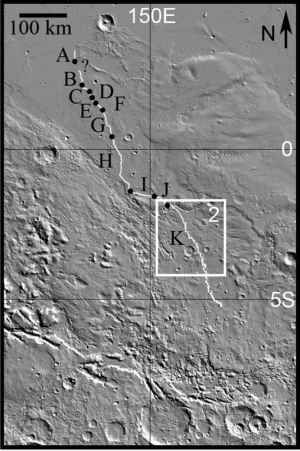
MEANDERING OVER MARS, Aeolis Serpens winds as a ridge across Aeolis Dorsa. But the ridge was once a river channel. After stream flow ceased, groundwater cemented the riverbed sediments. When the surrounding ground eroded, the former watercourse was left standing high. (Image is taken from Figure 1 in the paper.)
Such a “landform inversion” is also the origin for Aeolis Serpens, the longest sinuous ridge known on Mars, says a team of geologists led by Rebecca Williams (Planetary Science Institute). Reporting in Icarus, the scientists note that the Aeolis ridge changes character along its length and is not completely continuous. This they attribute to the cementation varying in effectiveness, a feature seen in portions of the South Australia paleoriver as well.
Using images from the CTX and HiRISE cameras on the Mars Reconnaissance Orbiter, the group traced the Aeolis Serpens ridge for a distance of approximately 500 kilometers (300 miles). They note that the southernmost section may not simply dwindle away, but could be buried by later sediments, and thus the Aeolis channel may have been even longer originally.
The team also determined elevations along the ridge using stereographic pairs of images. These led the scientists to construct profiles and cross-sections for the meandering paleochannel at stages along its path. They found that the ridge adopts “a number of forms including trough, trace, single-ridge and double-ridge morphologies.” These, they explain, likely reflect changes in the groundwater’s ability to cement riverbed sediments, as well as the kinds of sediments in the channel.
Regarding the ridge’s place in Martian geologic history, the scientists note, “Aeolis Serpens is one of a cluster of sinuous ridges located between the two westernmost lobes of the Medusae Fossae Formation.”
This enigmatic formation has numerous suspected origins, although most scientists currently lean toward it being volcanic ash. The team writes, “Prior studies concluded that the ignimbrite [volcanic ashflow] hypothesis matches well all of the major observations.” Because the formation’s material is porous, groundwater could easily migrate through it, with both stream flow and groundwater cementation being concentrated near the lowest layers of the formation.
“Based on the stratigraphic relationships,” the team concludes, “Aeolis Serpens formed early in the emplacement of the Medusae Fossae Formation.” They add that the river probably flowed at a rate of 100 to 1,000 cubic meters per second. Yet the team cautions that this is only a rough estimate.
Because cementation varied along the paleoriver’s length, so does the shape and profile of the ridge. As a result, they note, in this case, “meander wavelength and radius of curvature can be reliably measured, but flow width and gradient may not be preserved or accurately determined.”


