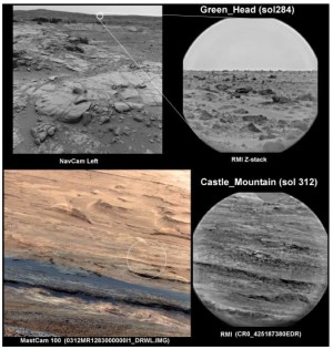
ONE SHARP EYE. ChemCam's Remote Micro-Imager, normally used on targets close to the rover, can also take sharp images of remote targets when focused at infinity. Green Head was about 100 to 300 meters away, and Castle Mountain was 4.7 to 6 km distant. (Image taken from Figure 1 in the abstract.)
The Mars rover Curiosity carries six “engineering” cameras: the front and rear Hazcam pairs, and the left and right Navcams. These are designed to help mission controllers steer a safe and scientifically productive course for the rover. The rover project can add a pehaps surprising imager to the path-selection armory: the ChemCam instrument’s Remote Micro-Imager (RMI).
In a poster talk (PDF) at the 45th Lunar and Planetary Science Conference in The Woodlands, Texas, Stéphane Le Mouélic (CNRS/Université de Nantes, France) and a team of colleagues reported on tests of the RMI camera as a scouting camera.
The team says the RMI’s “main objective is to remotely determine the elemental composition of soils and rocks situated at distances up to 7 meters from the rover.” In addition, they explain, the objectives of the RMI are to provide geomorphologic context for the laser spectrometer, locate its laser pits, document the changes induced by the laser shots on the target, and study Martian rocks and soils at high resolution.
However, the team discovered that when focused at infinity, the camera has a resolution of about 2 millimeters per pixel at a distance of 100 meters (330 feet). This gives the RMI the highest resolution of the cameras on the rover’s mast, almost four times higher than the Mastcam in its telephoto lens mode.
After shooting an image mosaic of targets at distances ranging from 4 kilometers to about 10 km, the scientists note, “Several geological features, which cannot be seen in HiRISE or Mastcam images, such as ripples on a dune field, and layers and boulders, were visible in the mosaic.”
They conclude that “the RMI can therefore play a major role in the investigation of distant areas of geological interest, either for scientific studies, or for the rover traverse planning.”


