Remote sensing of Mars usually happens when spacecraft sensors look down from orbit around the Red Planet. But sensors on Earth can also get in on the fun, especially when they actively reach out to the planet via radio waves.

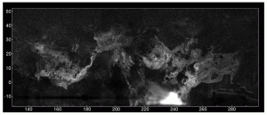
RADAR VOLCANICS. As seen by the Arecibo Observatory's radar, the major volcanic regions of Mars stand out in a radar-roughness map as swirling bands of gray. Figures on the left and bottom are degrees of latitude and east longitude, respectively. Elysium Mons stands near 145° east and 25° north, while Olympus Mons is at about 230° east and 20° north. (Image taken from Figure 1 in the paper.)
A team of radar astronomers and planetary scientists led by John Harmon (National Astronomy and Ionosphere Center, Arecibo Observatory) reported recently in Icarus (June 25, 2012) about improved observations made from October 2005 to February 2012. The team used the 300-meter (1,000 foot) dish at Arecibo, Puerto Rico, with the upgraded S-band radar at a wavelength of 12.6 centimeters (about 5 inches). The observations have a resolution at Mars of about 3 kilometers (2 miles).
The team’s mapping covered the major volcanic provinces of Tharsis, Elysium, and Amazonis, showing depolarized radar reflectivity. This serves as a proxy for surface roughness on scales about the size of the radar wavelength.
“We find that vast portions of these regions are covered by radar-bright lava flows exhibiting circular polarization ratios close to unity, a characteristic that is uncommon for terrestrial lavas and that is a likely indicator of multiple scattering from extremely blocky or otherwise highly disrupted flow surfaces,” they report.
The researchers found that all of the major volcanos have radar-bright features on their slopes. But the bright areas on Olympus Mons are very patchy, and the summit plateau of Pavonis Mons is entirely radar-dark. Minor volcanos also appear mostly radar-dark, suggesting mantling by dust or explosively erupted (pyroclastic) materials.
In addition, they say, several areas away from volcanos also show as radar-bright, indicating rough-surface lava flows. The team notes, “South Amazonis shows perhaps the most complex radar-bright structure on Mars.” It includes features that correspond to platy-ridged flows similar to those seen in the Cerberus region of Elysium.


Pingback: Researchers Send Mars Some Radar Love | Alkaon Network