After more than 100 sols (Martian days) in Gale Crater, NASA’s Curiosity rover has driven some 500 meters (1,600 feet), traversing several rock units. A sketch of the crater floor’s geological history is emerging.

HIGHER IS YOUNGER and lower is older: Curiosity descended in elevation and time as it drove eastward from Bradbury Landing. (Image from abstract.)
On its half-kilometer drive from its landing site on Bradbury Rise eastward toward Yellowknife Bay, Curiosity descended about 15 m (50 ft) in elevation. While much of the drive was across loose sand and gravel sediments, Curiosity also passed several outcrops of bedrock. These gave scientists a look at the rock units making up part of the Gale Crater floor.
A team of researchers led by Kathryn Stack (Caltech) reported (PDF) on the first drafts for a stratigraphic column for Gale’s floor at the 44th Lunar and Planetary Science Conference in The Woodlands, Texas.
“This study presents an inventory of outcrops targeted by Curiosity, grouped by lithological properties observed in Mastcam and Navcam imagery,” the researchers say. The team identified potential outcrop locations in color Mastcam and Navcam images using thickness, orientation, and similarity to nearby rock fragments so as to distinguish outcrops from “float,” rocks separated from their original location.
They then sorted and classified the outcrops by tone and color, presence of bedding, grain-size, and weathering style into several types. These types included conglomerates, fine-grain beds, and thickly bedded and fractured ones.
“Creating stratigraphic columns from a 2D rover traverse cross-section requires several assumptions,” the team cautions. These were that the outcrops represent layers located where they formed, that they were deposited horizontally and are still horizontal so that outcrop elevations reflect their stratigraphic position, and finally, that younger units lie above older ones.

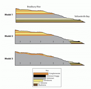
THREE MODELS for the local geology at the Curiosity landing site. In each, coarse outcrops of gravel and pebbles ("conglomerates") lie on top. These represent sediments deposited by ancient stream flow. Thickly bedded mudstones on the bottom reflect fine-grain sediments, perhaps deposited in at the far end of an alluvial fan. (Image from K. Stack.)
Model 1 assumes a “layer-cake” stratigraphy where fine-grained cross-stratified sandstones are interbedded with the Bradbury gravels. In this model, the rock units of Yellowknife Bay are older than those exposed on Bradbury Rise.
In Model 2, the Yellowknife Bay units represent a distinct sequence of rocks from those deposited on Bradbury Rise. In this scenario the rocks at Yellowknife Bay are in on-lap relationship with those of Bradbury Rise meaning that the Yellowknife Bay sequence may be younger or equivalent in age to the rocks of Bradbury Rise.
Model 3 considers the Bradbury conglomerates to be the youngest unit in the sequence, deposited unconformably as a thin surficial deposit on Bradbury Rise.
“It may not be possible to distinguish between the three stratigraphic models at this point in the mission,” the team acknowledges. But they note that stratigraphic frameworks such as these can help guide the selection of targets for camera observations, drilling, and detailed geochemical analysis.


