


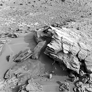
 Sol 840, December 15, 2014, update from USGS: “The 5-meter drive planned for Sol 837 placed the rover near the outcrop dubbed “Whale Rock” as intended. Front Hazcam images show blocks that appear to have fallen from the outcrop and in-place bedrock patches; both can be reached by the arm instruments, so the Sol 840 plan includes MAHLI images from 25 cm standoff distance of the block and bedrock targets “San Andreas,” “Tecoya,” “Gem Hill” and “San Bernardino.” The arm will also be used to image the… [More at link]
-
Recent Posts
Archives
Links
general
mission instruments
- CRISM: Compact Reconnaissance Imaging Spectrometer for Mars
- CTX: Context Camera
- HiRISE: High Resolution Imaging Science Experiment
- MARSIS: Mars Advanced Radar for Subsurface and Ionosphere Sounding
- SHARAD: Shallow Radar
- THEMIS: Thermal Emission Imaging System
missions
- All Mars missions list
- Curiosity rover
- ExoMars
- Hope (al-Amal) orbiter
- InSight
- Mars Atmosphere and Volatile Evolution Mission (MAVEN)
- Mars Exploration Rovers (MER)
- Mars Express (MEX)
- Mars Odyssey
- Mars Orbiter Mission (MOM) / Mangalyaan
- Mars Reconnaissance Orbiter (MRO)
- Mars Science Laboratory (MSL)
- Perseverance Rover
- Tianwen-1 orbiter/rover
news