


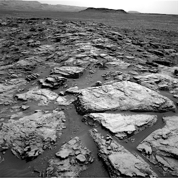
 Sol 1501, October 25, 2016, update by USGS scientist Lauren Edgar: On Sol 1500 Curiosity drove 30 m to the south, crossing into a quadrangle that we informally named “Bar Harbor,” after Bar Harbor, Maine. As a reminder, prior to landing we divided up the landing ellipse and nearby areas into square quads (1.5 km on a side), and assigned each quad a name of a town with a population of less than 100,000 people. As Curiosity investigates rock targets within a quad, we assign names to the targets that correspond to geologic formations and features from that town on Earth. After driving through the “Windhoek” quad for quite some time, we are now in the “Bar Harbor” quad, and the naming scheme will follow names from that town. [More at link]
-
Recent Posts
Archives
Links
general
mission instruments
- CRISM: Compact Reconnaissance Imaging Spectrometer for Mars
- CTX: Context Camera
- HiRISE: High Resolution Imaging Science Experiment
- MARSIS: Mars Advanced Radar for Subsurface and Ionosphere Sounding
- SHARAD: Shallow Radar
- THEMIS: Thermal Emission Imaging System
missions
- All Mars missions list
- Curiosity rover
- ExoMars
- Hope (al-Amal) orbiter
- InSight
- Mars Atmosphere and Volatile Evolution Mission (MAVEN)
- Mars Exploration Rovers (MER)
- Mars Express (MEX)
- Mars Odyssey
- Mars Orbiter Mission (MOM) / Mangalyaan
- Mars Reconnaissance Orbiter (MRO)
- Mars Science Laboratory (MSL)
- Perseverance Rover
- Tianwen-1 orbiter/rover
news