


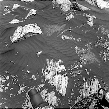
 Sol 1643, March 20, 2017, update by USGS scientist Ken Herkenhoff: MSL drove about 28 meters toward the south on Sol 1642 and again is in an area with Murray Formation bedrock blocks surrounded by dark sand. I helped plan ChemCam observations today, and we settled on a target called “Vinalhaven” at the left side of the layered bedrock exposure seen at upper left in this image. Right Mastcam will image Vinalhaven and coarse material to the right of that bedrock block, at targets named “Rindgemere” and “Hurd Mountain.” Then Right Mastcam will image more distant targets, with a 3×1 mosaic of a layered rock about 11 meters away dubbed “Saint Daniel” and a 28×1 mosaic of the hematite-bearing “Vera Rubin Ridge”… [More at link]
-
Recent Posts
Archives
Links
general
mission instruments
- CRISM: Compact Reconnaissance Imaging Spectrometer for Mars
- CTX: Context Camera
- HiRISE: High Resolution Imaging Science Experiment
- MARSIS: Mars Advanced Radar for Subsurface and Ionosphere Sounding
- SHARAD: Shallow Radar
- THEMIS: Thermal Emission Imaging System
missions
- All Mars missions list
- Curiosity rover
- ExoMars
- Hope (al-Amal) orbiter
- InSight
- Mars Atmosphere and Volatile Evolution Mission (MAVEN)
- Mars Exploration Rovers (MER)
- Mars Express (MEX)
- Mars Odyssey
- Mars Orbiter Mission (MOM) / Mangalyaan
- Mars Reconnaissance Orbiter (MRO)
- Mars Science Laboratory (MSL)
- Perseverance Rover
- Tianwen-1 orbiter/rover
news