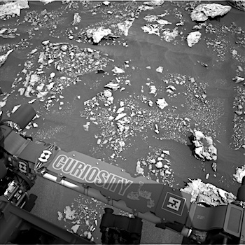
 Sol 1678, April 26, 2017, update by MSL scientist Ken Herkenhoff: This MSL drove another 33 meters on Sol 1677, and again is surrounded by rocky outcrops partly covered by dark sand. Although Rover Planner support was available for “touch and go” contact science, the GEO science theme group decided that the limited reachable outcrop did not warrant contact science, and that driving is the top priority for this plan. APXS data were successfully acquired on Sol 1677, so are not urgently needed in this new location. The plan for Sol 1678 therefore focuses on remote sensing, with ChemCam 10×1 rasters on “Hancock Point,” a darker exposure of bedrock, and “Crocker Mountain,” a more normal-looking bedrock exposure. Mastcam context imaging of these targets will be… [More at link]
-
Recent Posts
Archives
Links
general
mission instruments
- CRISM: Compact Reconnaissance Imaging Spectrometer for Mars
- CTX: Context Camera
- HiRISE: High Resolution Imaging Science Experiment
- MARSIS: Mars Advanced Radar for Subsurface and Ionosphere Sounding
- SHARAD: Shallow Radar
- THEMIS: Thermal Emission Imaging System
missions
- All Mars missions list
- Curiosity rover
- ExoMars
- Hope (al-Amal) orbiter
- InSight
- Mars Atmosphere and Volatile Evolution Mission (MAVEN)
- Mars Exploration Rovers (MER)
- Mars Express (MEX)
- Mars Odyssey
- Mars Orbiter Mission (MOM) / Mangalyaan
- Mars Reconnaissance Orbiter (MRO)
- Mars Science Laboratory (MSL)
- Perseverance Rover
- Tianwen-1 orbiter/rover
news


