


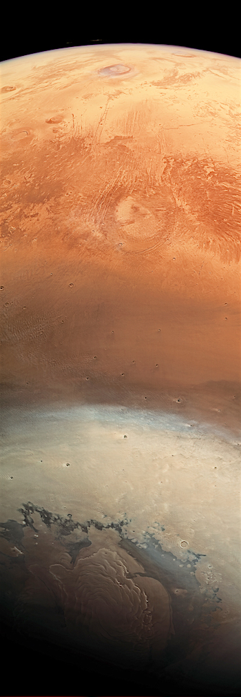
 Which way is up in space? Planets are usually shown with the north pole at the top and the south pole at the bottom. In this remarkable image taken by ESA’s Mars Express, the Red Planet is seen with north at the bottom, and the equator at the top.
The image was taken on 19 June for calibrating the high-resolution stereo camera, while Mars Express was flying from north to south. The camera’s nine channels – one downward-pointing, four colour and four stereo – panned over the surface to record a large area with the same illumination conditions. At the same time, the camera was shifted to the horizon, instead of just pointing to the surface as in routine imaging.
The result is this rare wide-angle view of the planet, with the illuminated horizon near the equator at the top of the image, and the shadowed north pole at the bottom.
The northern polar cap was composed of water ice and dust at the time of imaging, at the beginning of spring. The carbon dioxide ice present in winter had already evaporated from the solid form to a gas. Similarly, water-ice also evaporates, injecting a large amount of water into the atmosphere that is circulated to the south by atmospheric motions. When the seasons change back, carbon dioxide frost and water-ice build up again.
Panning south, the view soaks up sights of some of the planet’s largest volcanoes in the Tharsis region. Tharsis covers an area larger than Europe, and rises some 5 km above the planet’s average elevation, with volcanoes towering 10–22 km in height.
The largest volcanic giant, Olympus Mons, is out of view in this scene, leaving Alba Mons to take centre stage in the top half of the image, with a diameter of more than 1000 km… [More at link]