 [Editor’s note: From a paper by Joel Davis and six co-authors recently published in the Journal of Geophysical Research.]
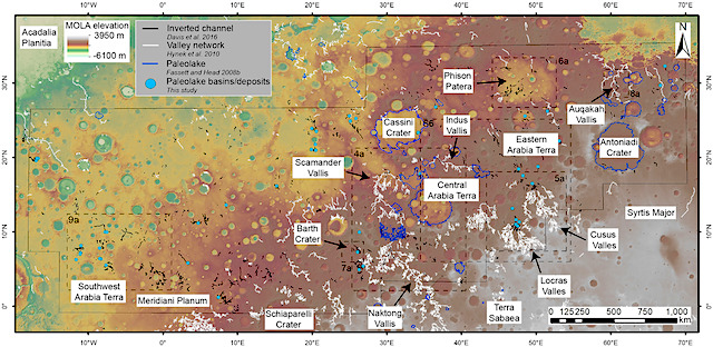
• Fluvial depositional systems, 50–100 m in stratigraphic thickness, are common across Arabia Terra, Mars
• These deposits represent former rivers (at least 100–200 km long), floodplains, and lakes and are found filling fluvial valleys and basins
• These systems are mid‐Noachian to early Hesperian in age and represent significant periods of geologic time
Landscape features identified as former rivers and lakes are common across ancient Martian surfaces (>3.7 billion years ago), strong evidence for an ancient hydrologic cycle. However, the nature of the ancient climate and environment remains unclear and detailed investigations of Mars’s geology are necessary to help constrain this.
Using high‐resolution satellite images, we investigate a series of sinuous ridges preserved at the Martian surface throughout the ancient Arabia Terra region. These sinuous ridges often occur downslope of river valleys, commonly as the valleys enter topographic basins. The ridges are usually found on the oldest exposed geological surfaces. The morphology of the ridges and their relationship to river valleys suggests that they are sedimentary rocks, which form in or next to rivers.
We interpret the basins as ancient lakes and their associated deposits as lake sediments. These rivers were active ~3.7 billion years ago and transported and deposited sediment through the Arabia Terra region. On Earth, rivers typically take between 50,000 and 1,000,000 years to develop such thick deposits. These river deposits are now exposed as ridges due to erosion. The formation of these rivers and lakes in Arabia Terra was likely due to prolonged and episodic precipitation‐driven erosion. [More at link]


