THEMIS: False colors on Terra Cimmeria

Terra Cimmeria in false color (THEMIS_IOTD_20180904)THEMIS Image of the Day, September 4, 2018. Today’s VIS image shows plains and craters in Terra Cimmeria.

The THEMIS VIS camera contains 5 filters. The data from different filters can be combined in multiple ways to create a false color image. These false color images may reveal subtle variations of the surface not easily identified in a single band image.

See more THEMIS Images of the Day by geological subject.

Posted in Reports | Tagged , , , , , , , , | Comments Off

HiRISE: Dunes in south Xainza Crater

tumblr_pe8t2wL6hS1rlz4gso2_1280Dunes in south Xainza Crater. They look so innocent…

Beautiful Mars series. [More at links]

Posted in Reports | Tagged , , , , , , , , , , | Comments Off

Curiosity: Skies less dusty

2156-navcam-NSol 2156, August 30, 2018. Having driven away from the Stoer drill site, Curiosity took a series of Navcam shots to the north, which show improving atmospheric conditions. It also used the Mastcam’s 34mm optics to take a set of color views in the direction it will drive. Click either image to enlarge it.

Sol 2156 raw images (from all cameras).

2156-mastcam34

Posted in Reports | Tagged , , , , , , , , | Comments Off

Weather update from Gale Crater

Posted in Reports | Tagged , , , , , , , , | Comments Off

THEMIS: False-color craters and plains in Terra Cimmeria

False-color crater and plains in Terra Cimmeria (THEMIS_IOTD_20180831)THEMIS Image of the Day, August 31, 2018. Today’s false color image shows several craters and plains of Terra Cimmeria.

The THEMIS VIS camera contains 5 filters. The data from different filters can be combined in multiple ways to create a false color image. These false color images may reveal subtle variations of the surface not easily identified in a single band image.

See more THEMIS Images of the Day by geological subject.

Posted in Reports | Tagged , , , , , , , , , , | Comments Off

Opportunity: Martian skies clearing over rover

PIA21724_hires[Editor's note: The above images were taken on July 7, 2017.]

A planet-encircling dust storm on Mars, which was first detected May 30 and halted operations for the Opportunity rover, continues to abate.

With clearing skies over Opportunity’s resting spot in Mars’ Perseverance Valley, engineers at NASA’s Jet Propulsion Laboratory in Pasadena, California, believe the nearly 15-year-old, solar-powered rover will soon receive enough sunlight to automatically initiate recovery procedures — if the rover is able to do so. To prepare, the Opportunity mission team has developed a two-step plan to provide the highest probability of successfully communicating with the rover and bringing it back online.

“The Sun is breaking through the haze over Perseverance Valley, and soon there will be enough sunlight present that Opportunity should be able to recharge its batteries,” said John Callas, Opportunity project manager at JPL.

“When the tau level [a measure of the amount of particulate matter in the Martian sky] dips below 1.5, we will begin a period of actively attempting to communicate with the rover by sending it commands via the antennas of NASA’s Deep Space Network. Assuming that we hear back from Opportunity, we will begin the process of discerning its status and bringing it back online.” [More at link]

Posted in Reports | Tagged , , , , , , , , , , , | Comments Off

Curiosity update: The story of Stoer

2134MH0001530000802737R00_DXXX-br2Sol 2156 August 30, 2018, update by MSL scientist Abigail Fraeman: After an extremely productive couple of weeks, we are finishing up our work at Stoer! We’ll take some quick ChemCam and Mastcam observations of the tailings dump pile tosols before packing up and starting our drive up the ridge towards our next drill location. As we leave Stoer, I’d like to take some time to share the story of how and why we came to drill this particular location.

We first attempted to drill Vera Rubin Ridge back on sol 2112 at the “Voyageurs” target. However, the drill made only a few millimeters of progress into that target before stopping because the rate of downward progress was so slow. The drill itself performed exactly as it was designed but the Voyageurs rock was simply too hard! It was pretty interesting from a science perspective to see this result, but it also meant we had to work quickly to figure out a plan B.

The science team agreed it was scientifically important enough to get a drill sample from the lower part of Vera Rubin Ridge that we should try again. But how could we improve our chances of finding a rock that would be softer and easier to drill than Voyageurs? It was time to think like geologists… [More at link]

Posted in Reports | Tagged , , , , , , , , , , , | Comments Off

HiRISE: Relatively recent impact in Arcadia Planitia

tumblr_pe72utbekq1rlz4gso2_1280Remember the great impacts of yore? Well, those days are long gone, but Mars still gets hit with impacts and we’ve catalogued hundreds of them. This particular impact formed sometime between May 2014 and October 2017. It’s only meters in diameter and the color cutout is at full resolution.

Beautiful Mars series. [More at links]

Posted in Reports | Tagged , , , , , , , , | Comments Off

River and lake landforms in Melas Chasma

figure-1b[Editor’s note: From a paper by Joel Davis and five co-authors recently published in the Journal of Geophysical Research.]

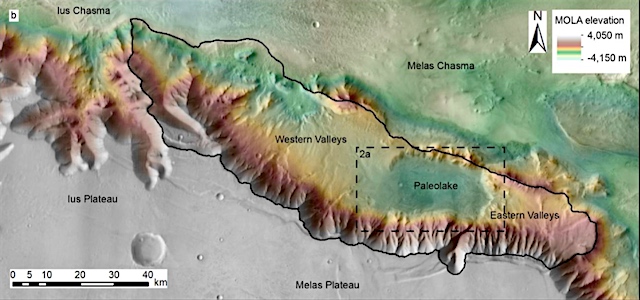
Episodic and Declining Fluvial Processes in Southwest Melas Chasma, Valles Marineris, Mars

• Episodic fluvial processes occurred in the southwest Melas basin, Valles Marineris, Mars, likely during the Hesperian period
• Evidence for multiple “wet and dry” periods is preserved in the fluvial systems and paleolacustrine deposits
• Local Valles Marineris climate likely supported runoff and precipitation and transitioned from perennial to ephemeral conditions

There is strong evidence that liquid water was widespread on ancient Mars (prior to 3.7 billion years ago) and features such as rivers and lakes were common. However, it is unclear how Mars changed from this relatively wet state to the cold and dry planet we see today.

Using high‐resolution satellite images, we investigate part of the canyon system Valles Marineris, near the equator. This region of Valles Marineris, the southwest Melas basin, forms a depression, and contains sediments and landforms which are from this middle period of Mars’ history. We examined both the sediments and landforms and found they most likely formed due to the presence of river valleys and channels and lakes.

We find that the southwest Melas basin had repeated wet and dry periods, when the rivers and lakes dried up, before later refilling. During this time, hundreds of meters of sediment was deposited and eroded in the basin. This wet and dry cycle repeated several times, before ultimately ceasing.

We also find that river valleys were present on the plateaus of Valles Marineris, above the basin. Our results suggest that liquid water persisted after 3.7 billion years ago, at least locally on this part of Mars. [More at link]

Posted in Reports | Tagged , , , , , , , | Comments Off

Curiosity: Moving on

2156-navcamSol 2156, August 30, 2018. Having finished operations at the Stoer site, Curiosity has driven toward the southeast about 130 feet (39 meters). The drive brought the rover onto a higher part of Vera Rubin Ridge and part of Mt Sharp is now in view at left in the image above. Click the image to enlarge it.

Sol 2156 raw images (from all cameras).

Posted in Reports | Tagged , , , , , , , , , | Comments Off