Curiosity: Zapping Ailsa Craig

2125-rmi-ailsa-craig
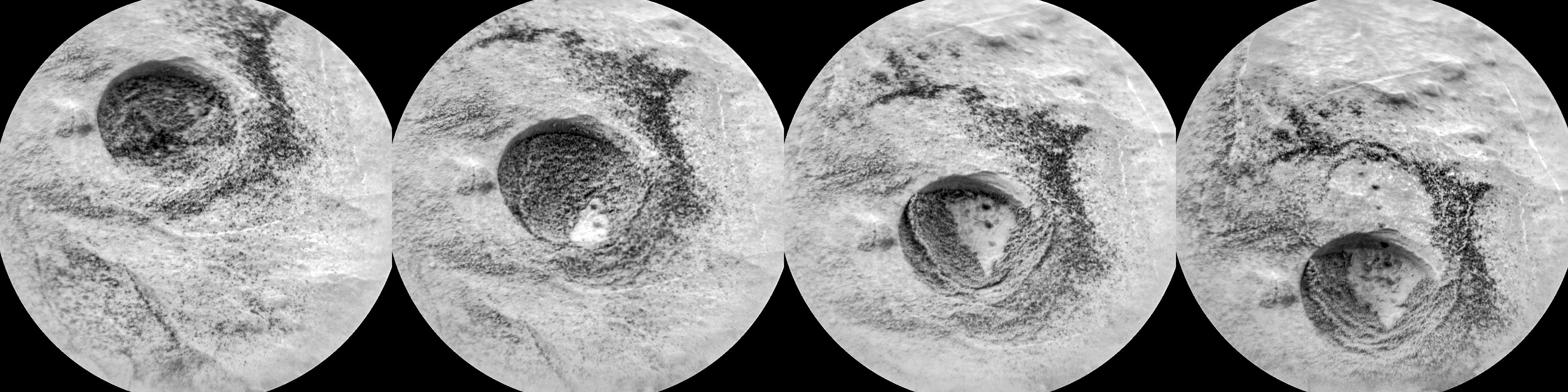
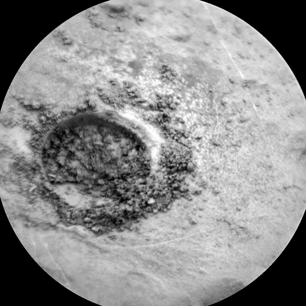
Sol 2125, July 29, 2018. Penetrating the rock at Ailsa Craig, like that at Voyageurs, proved to be too difficult for Curiosity’s drill. So mission scientists turned the ChemCam’s laser zapper onto the shallow hole and loose tailings, as the Remote Micro-Imager camera shows. Note how the energy of the laser vaporizing a bit of rock blows away dust and tailings. Click image to enlarge it.

Sol 2125 raw images (from all cameras).

Posted in Reports | Tagged , , , , , , , , , , | Comments Off

THEMIS: Daedalia Planum crater

Daedalia Planum crater (THEMIS_IOTD_20180730)THEMIS Image of the Day, July 30, 2018. This VIS image shows part of an unnamed crater on the northwest margin of Daedaia Planum. Lava flows are visible around the crater rim.

The interior of the crater has been filled by a material that is now being eroded to create the ridge and valley formation at the upper left part of the image.

See more THEMIS Images of the Day by geological subject.

Posted in Reports | Tagged , , , , , , , , , , , , | Comments Off

Curiosity update: It’s a hard rock life

CR0_585953001PRC_F0720386CCAM01122L1-br2Sols 2124-26, July 27, 2018, update by MSL scientist Ryan Anderson: Our attempt at drilling the target “Ailsa Craig” was partly successful: the drill behaved exactly as it was supposed to, but unfortunately we weren’t able to drill very deep. The rock here is just too hard! Since we didn’t get a nice deep drill hole, the plan for the weekend is to do some final observations at this location and then move on another location to try again.

The science block on Sol 2124 starts with a ChemCam passive observation of the pulverized rock tailings from our shallow drill hole. That will be followed by an “active” (laser zapping) observation of the vein target “LamLash Bay” accompanied by Mastcam multispectral images. Later in the afternoon, Mastcam and Navcam will do some atmospheric observations to monitor the dust levels as the planet-encircling… [More at link]

Posted in Reports | Tagged , , , , , , , , , , | Comments Off

HiRISE: Cluster of dunes in Tyrrhena Terra

tumblr_pcg295MDKo1rlz4gso1_1280A cluster of dunes within a crater in Tyrrhena Terra. Beautiful Mars series. [More at links]

Posted in Reports | Tagged , , , , , , , , , | Comments Off

Curiosity: Shallow drill hole at Ailsa Craig

NLB_585951829EDR_F0720386NCAM00309M_Sol 2123, July 27, 2018. Curiosity put its drill to work on the brushed surface of the target dubbed Ailsa Craig — and got just a shallow hole. As at the Voyageurs site, the drill dug only a very short distance into the rock.

At right top is the Navcam view of the slab after the brushing and drilling, and below is the Remote Micro-Imager view of the pit and tailings left by the drill’s action. Both images enlarge when clicked.CR0_585953001PRC_F0720386CCAM01122L1

Sol 2123 raw images (from all cameras).


Posted in Reports | Tagged , , , , , , , , , | Comments Off

HiRISE: This is not the hydrothermal deposit you’re looking for

ESP_055282_2125A hotspot for exploration on Mars centers on areas that were once, or are currently, next to a significant source of heat such as volcanoes. Martian volcanoes have not been active for the last couple million years, but beneath the shifting sands and dust of the Red Planet we find old lava flows frozen in time.

These ancient lava flows may have provided a source of heat, along with liquid water or subsurface ice, to generate an environment conducive for the development of ancient life. Geological evidence for hot water interacting with rock is what we mean by hydrothermal: sites with these conditions are very difficult to identify from orbit…. [More at link]

Posted in Reports | Tagged , , , , , , , , , | Comments Off

HiRISE: Light-toned layering in Louros Valles

tumblr_pcg1cbUrJF1rlz4gso2_1280Light-toned layering in Louros Valles. Louros Valles is to the east of Noctis Labyrinthus.

Beautiful Mars series. [More at links]

Posted in Reports | Tagged , , | Comments Off

Opportunity: Deep sleep continues beneath raging dust storm

[Editor note: Entry bumped because of update]
NASA Mars Exploration Rover Status Report, updated at 2:25 p.m. PDT on July 26, 2018: It’s the beginning of the end for the planet-encircling dust storm on Mars. But it could still be weeks, or even months, before skies are clear enough for NASA’s Opportunity rover to recharge its batteries and phone home. The last signal received from the rover was on June 10.

Scientists observing the global event — which is actually caused by a series of local and regional storms throwing dust into the Martian atmosphere — say that, as of Monday, July 23, more dust is falling out than is being raised into the planet’s thin air. That means the event has reached its decay phase, when dust-raising occurs in ever smaller areas, while others stop raising dust altogether.

Surface features in many areas are beginning to re-appear as seen from orbit. This should even be apparent through telescopes on the ground: Next week, Mars will make its closest approach to Earth since 2003 — a particularly good time for observing the Red Planet.  Meanwhile, in Gale Crater, the nuclear-powered Mars Science Laboratory/Curiosity rover has noted a decline in dust overhead.

Temperatures in the middle atmosphere of Mars are no longer rising, and in some areas are starting to decrease. That indicates less solar heating by the dust.

The changes were spotted by the Mars Color Imager (MARCI), a wide-angle camera, and by the Mars Climate Sounder (MCS), a temperature profiler, on NASA’s Mars Reconnaissance Orbiter (MRO). MARCI is managed by Malin Space Science Systems in San Diego. MSL, MRO and MCS are managed by NASA’s Jet Propulsion Laboratory.

All of NASA’s Mars spacecraft have been observing the storm, both to support the Opportunity mission and to collect unique science about this global phenomenon. [More at link]

Posted in Reports | Tagged , , , , , , , , , , | Comments Off

THEMIS: Wind-etched ridges on Zephyria Planum

Etched ridges show change in wind direction (THEMIS_IOTD_20180727)THEMIS Image of the Day, July 27, 2018. This VIS image is located near Zephyria Planum. Winds of two different directions have excavated a poorly cemented surface into linear ridge features called yardangs.

Examining the structure of the ridges, it appears that winds first blew from the upper left of the image. Then perhaps after a change in climate, winds blew toward the upper right, carving a new pattern on top of the older one. The ridges are not perpendicular, but intersect at a wider angle.

See more THEMIS Images of the Day by geological subject.

Posted in Reports | Tagged , , , , , , , , , | Comments Off

HiRISE: Dark side of dust avalanches

tumblr_pcbvjhDqcW1rlz4gso1_1280The dark side of dust avalanches. Changes on the Martian surface are detected by imaging the same area more than once. Here, we see several new dust avalanches on the slopes of ridges within the Olympus Mons Aureole. These changes occurred within six years. (Also see the animated GIF).

Dust avalanches create slope streaks that expose darker materials usually hidden below a lighter-toned layer. Cascading fine-grained material easily diverts around boulders or alters direction when encountering a change in slope (see the top right corner of the first close-up). The dark steak in another close-up is approximately 1 kilometer in length that we didn’t see in a previous image. Past avalanche sites are still visible and fading slowly as dust settles out of the atmosphere and is deposited on the dark streaks over time.

We also see boulders and their shadows that are a meter or greater in size. Movement of any of these boulders down the slope could trigger future avalanches.

Beautiful Mars series. [More at links]

Posted in Reports | Tagged , , , , , , , , , | Comments Off