Latest weather at Gale Crater and Elysium Planitia

Daily Elysium charts and data (temperature, wind speed, atmospheric pressure) here.

Posted in Reports | Tagged , , , , , , , , , , , , , , | Comments Off

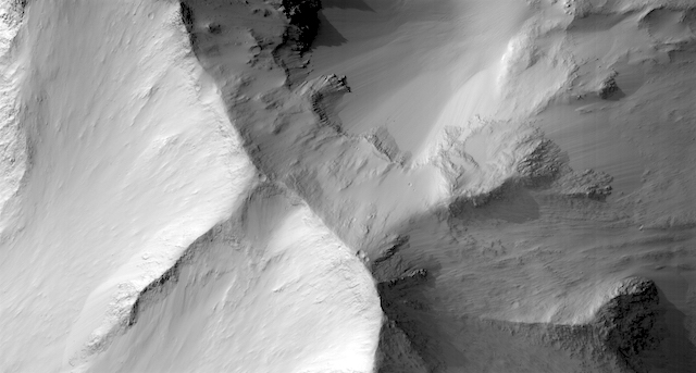
HiRISE: The hills in Eos Chasma

ESP_054965_1640The hills in Eos Chasma. They may not be alive with the sound of music, but we’ll take the opportunity to look for recurring slope lineae, small gullies and slumped material.

HiRISE Picture of the Day archive. [More at links]

Posted in Reports | Tagged , , , , , , , , , , , , | Comments Off

THEMIS: Cerberus Fossae and Tartarus Montes

Cerbeus Fossae and Tartarus Montes (THEMIS_IOTD_20190725)THEMIS Image of the Day, July 25, 2019. Today’s VIS image shows part of Cerberus Fossae. These large graben cut across the Tartarus Montes in Elysium Planitia.

A graben forms when large blocks of material slide downward between paired faults in regions of extensional stresses.

Explore more THEMIS Images of the Day by geological subject.

Posted in Reports | Tagged , , , , , , , , , , , | Comments Off

Curiosity update: Powering through!

NRB_617033844EDR_F0762360NCAM00263M_-br2Sol 2475, July 23, 2019, update by MSL scientist Dawn Sumner: It’s winter for Curiosity, and it’s cold. That means that we have to spend extra energy heating up the instruments and motors for our activities. All of our energy comes from batteries, charged by the RTG. The RTG gives us more power than solar panels would, but in the winter, we are still limited by the amount of power it can generate. That means we have to choose among various activities.

Tosol (today on Mars), we chose to save a little extra power for a big science day solorrow (tomorrow on Mars). Thus, we planned only one ChemCam analysis, which was on the target “Monreith,” accompanied by a Mastcam image to document the analysis. We also asked Curiosity to take a Mastcam mosaic looking west to document the topography. After playing photographer, Curiosity will drive up to the escarpment we’ve been imaging to the south (see yestersol’s update)… [More at link]

Posted in Reports | Tagged , , , , , , , , , , , , | Comments Off

Mars 2020 rover power system fueling begins

PIA23305_hiresNASA’s Associate Administrator for the Science Mission Directorate, Thomas Zurbuchen, has given the go-ahead to begin fueling the Mars 2020 rover’s Multi-Mission Radioisotope Thermoelectric Generator, or MMRTG. The generator will power the rover and help keep it warm while exploring the Red Planet.

“The progression of the Mars 2020 rover project is on schedule,” said Zurbuchen. “The decision to begin fueling the MMRTG is another important milestone in keeping to our timetable for a July 2020 launch.”

Essentially a nuclear battery, an MMRTG can provide about 110 watts of electrical power to a spacecraft and its science instruments at the beginning of a mission. The excess heat from the generator can also serve to keep spacecraft systems warm in cold environments. In all, 27 past U.S. space missions have used radioisotope power – from the Viking missions on Mars to the Voyager spacecraft entering interplanetary space to, most recently, the Curiosity rover on Mars and the New Horizons spacecraft that sailed past Pluto… [More at link]

Posted in Reports | Tagged , , , , , , , , | Comments Off

MARCI weather report, July 15-21, 2019

MARCI-July-16-2019For the past week on Mars, small sporadic dust storms continued along the south polar hood. Dust activity was also observed a bit further north over Solis Planum, central Cimmeria, and just south of eastern Valles Marineris. Looking to the northern lowlands, dust-lifting events were more infrequent. Northern Acidalia experienced some dust activity, which dipped southward across the region. In equatorial regions… [More at link, including video]

Posted in Reports | Tagged , , , , , , , , , , , , , , | Comments Off

2018 global dust storm according to Curiosity’s REMS instrument in Gale Crater

jgre21177-fig-0004-m[Editor’s note: From a paper by Daniel Viúdez‐Moreiras and 14 co-authors recently published in the Journal of Geophysical Research.]

Effects of the MY34/2018 Global Dust Storm as Measured by MSL REMS in Gale Crater

• Atmospheric opacity over Gale Crater was increased by more than 8 times and disturbed all the atmospheric variables measured by REMS
• REMS data suggest that the nighttime near‐surface atmosphere stability was reduced and its water abundance increased during the GDS
• The semidiurnal mode peaked after the local opacity maximum, suggesting different dust abundance inside and outside Gale

The Rover Environmental Monitoring Station (REMS) instrument is on board NASA’s Mars Science Laboratory (MSL) Curiosity rover. REMS has been measuring surface pressure, air, and ground brightness temperature, relative humidity, and ultraviolet (UV) irradiance since MSL’s landing in 2012. In Mars Year (MY) 34 (2018) a global dust storm reached Gale Crater at Ls ~ 190°.

REMS offers a unique opportunity to better understand the impact of a global dust storm on local environmental conditions, which complements previous observations by the Viking landers and Mars Exploration Rovers. All atmospheric variables measured by REMS are strongly affected albeit at different times.

During the onset phase, the daily maximum UV radiation decreased by 90% between sols 2075 (opacity ~1) and 2085 (opacity ~8.5). The diurnal range in ground and air temperatures decreased by 35 and 56 K, respectively, with also a diurnal‐average decrease of ~2 and 4 K respectively.

The maximum relative humidity, which occurs right before sunrise, decreased to below 5%, compared with prestorm values of up to 29%, due to the warmer air temperatures at night, while the inferred water vapor abundance suggests an increase during the storm.

Between sols 2085 and 2130, the typical nighttime stable inversion layer was absent near the surface as ground temperatures remained warmer than near‐surface air temperatures.

Finally, the frequency domain behavior of the diurnal pressure cycle shows a strong increase in the strength of the semidiurnal and terdiurnal modes peaking after the local opacity maximum, also suggesting differences in the dust abundance inside and outside Gale. [More at link]

Posted in Reports | Tagged , , , , , , , , , | Comments Off

HiRISE: Floor and north rim of Dokka Crater

ESP_054968_2575Floor and north rim of Dokka Crater. Dokka Crater is 52-kilometers in diameter and located in the north polar region of Mars. Its interior is presumably a remnant of a former polar cap with larger extension, so it could provide valuable information about the past Martian conditions. (see: Analysis of Frost Inside and Around Dokka Crater in the North Polar Region of Mars)

HiRISE Picture of the Day archive. [More at links]

Posted in Reports | Tagged , , , , , , , , , , , , | Comments Off

THEMIS: Bahram Vallis channel

Bahram Vallis channel (THEMIS_IOTD_20190724)THEMIS Image of the Day, July 24, 2019. Bahram Vallis crosses this VIS image. Bharam Vallis drains from the higher elevations of Lunae Planum into the Chryse Planitia basin.

At the base of several of the scalloped channel wall sections, deposits of material can be seen.

Explore more THEMIS Images of the Day by geological subject.

Posted in Reports | Tagged , , , , , , , , , , , | Comments Off

Evidence for fluvial deposition in Arabia Terra

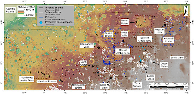
jgre21178-fig-0001-m[Editor’s note: From a paper by Joel Davis and six co-authors recently published in the Journal of Geophysical Research.]

A Diverse Array of Fluvial Depositional Systems in Arabia Terra: Evidence for mid‐Noachian to Early Hesperian Rivers on Mars

• Fluvial depositional systems, 50–100 m in stratigraphic thickness, are common across Arabia Terra, Mars
• These deposits represent former rivers (at least 100–200 km long), floodplains, and lakes and are found filling fluvial valleys and basins
• These systems are mid‐Noachian to early Hesperian in age and represent significant periods of geologic time

Landscape features identified as former rivers and lakes are common across ancient Martian surfaces (>3.7 billion years ago), strong evidence for an ancient hydrologic cycle. However, the nature of the ancient climate and environment remains unclear and detailed investigations of Mars’s geology are necessary to help constrain this.

Using high‐resolution satellite images, we investigate a series of sinuous ridges preserved at the Martian surface throughout the ancient Arabia Terra region. These sinuous ridges often occur downslope of river valleys, commonly as the valleys enter topographic basins. The ridges are usually found on the oldest exposed geological surfaces. The morphology of the ridges and their relationship to river valleys suggests that they are sedimentary rocks, which form in or next to rivers.

We interpret the basins as ancient lakes and their associated deposits as lake sediments. These rivers were active ~3.7 billion years ago and transported and deposited sediment through the Arabia Terra region. On Earth, rivers typically take between 50,000 and 1,000,000 years to develop such thick deposits. These river deposits are now exposed as ridges due to erosion. The formation of these rivers and lakes in Arabia Terra was likely due to prolonged and episodic precipitation‐driven erosion. [More at link]

Posted in Reports | Tagged , , , , , , , , , , , , , | Comments Off