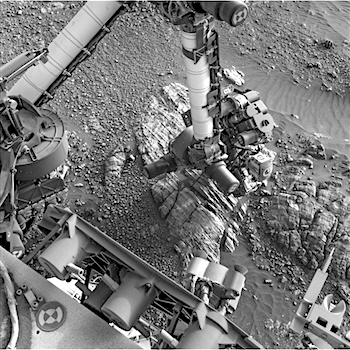
Curiosity update: A great outcrop!

2471MR0131120060704260C00_DXXX-br2Sol 2474, July 22, 2019, update by MSL scientist Kristen Bennett: Today’s one-sol plan included both remote science and contact science. The team planned a large Mastcam mosaic of the outcrop located to the south of Curiosity. The image above shows a Mastcam image of a different part of the outcrop that was imaged last week. When we see outcrops like this one that show a vertical exposure of laminated rocks, we capture it in high resolution Mastcam images so that scientists can look for sedimentary structures that give us clues as to how the rock formed…  [More at link]

Posted in Reports | Tagged , , , , , , , , , , , , | Comments Off

ExoMars 2020 radio science instrument tested

An ambitious instrument for ESA’s ExoMars 2020 mission has passed its testing in conditions resembling those on the Red Planet. It will now be transported to Russia for its acceptance review, followed by integration onto the Kazachok Surface Platform, scheduled for launch this time next year.

At about 8 x 8 x 20 cm plus a trio of antennas, ESA’s Lander Radioscience experiment, or LaRa for short, is a bit bigger than a 1-litre milk carton. But it functions as a high-performing transponder, tasked with maintaining an extremely stable direct radio-frequency link between Earth and Mars for a full martian year – two Earth years – once ExoMars has touched down.

Proposed by the Royal Observatory of Belgium, LaRa has been developed through ESA’s PRODEX programme – focused on developing science experiments for space – and funded by the Belgian Space Policy Office.

The latest testing of LaRa took place in ESA’s Mechanical Systems Laboratory (MSL) at the Agency’s ESTEC technical heart in Noordwijk, the Netherlands. This is a small-scale version of the adjacent ESTEC Test Centre, able to perform a wide range of space-simulating tests, but serving spacecraft instruments, subsystems or mini-satellites rather than full-size missions.

Following vibration testing on one of the MSL shaker to simulate the harsh conditions of launch, atmosphere re-entry, descent and Mars landing, LaRa was then placed inside a thermal vacuum chamber for nearly two weeks to perform functional testing in hot and cold conditions… [More at link]

Posted in Reports | Tagged , , , , , , , , , , | Comments Off

HiRISE: McLaughlin Crater dunes

ESP_054964_2020-2McLaughlin Crater dunes. This image is part of a seasonal monitoring campaign to detect changes and quantify migration rates of the dunes in McLaughlin Crater. McLaughlin is one of the deepest craters on Mars, and was named after Dean B. McLaughlin, an American astronomer (1901-1965).

HiRISE Picture of the Day archive. [More at links]

Posted in Reports | Tagged , , , , , , , , , , , | Comments Off

THEMIS: North polar layers and sand dunes

North polar layers and dunes (THEMIS_IOTD_20190723)THEMIS Image of the Day, July 23, 2019. Today’s VIS image shows part of the north polar cap, as well as sand dunes located on the floor of a polar trough.

The north polar cap is surrounded by numerous dune fields — nicknamed the north polar sand sea — as well as dunes within many of the troughs near the polar cap margin. This image was collected during northern summer.

Explore more THEMIS Images of the Day by geological subject.


Posted in Reports | Tagged , , , , , , , , , , , | Comments Off

Curiosity update: Additional contact science and a soliday at Sandside Harbour

NLB_616782180EDR_F0762194NCAM00207M_-br2Sols 2472-73, July 22, 2019, update by MSL scientist Lauren Edgar: Curiosity is still parked in front of an outcrop known as “Sandside Harbour” in order to investigate differences in the lighter and darker outcrop expressions. Contact science in the previous plan went well, and today we have one more opportunity to look for differences in sedimentary structures and composition before driving on to the next outcrop.

The plan starts with Mastcam multispectral observations to characterize the two different parts of this outcrop, as well as a unique fin of bedrock sticking out at “Joppa Shore.” Mastcam will also be used to document some nearby stratigraphy at “North Minch” and an interesting green rock named “Halkirk.” Then ChemCam will assess the chemistry of “Blackstones Bank” (part of the darker outcrop) and “Essendy”…. [More at link]

Posted in Reports | Tagged , , , , , , , , , , , , , , , , , | Comments Off

HiRISE: Dust devils dancing on dunes

PSP_005383_1255Dust devils dancing on dunes. Dust devils make dark, diffuse scribble markings on the surface by kicking up dust, and are especially active in the summertime over dark surfaces, such as those with many deposits of sand-sized material.

HiRISE Picture of the Day archive. [More at links]

Posted in Reports | Tagged , , , , , , , , | Comments Off

What does a marsquake look and feel like?

Southern California got all shook up after a set of recent quakes. But Earth isn’t the only place that experiences quakes: Both the Moon and Mars have them as well. NASA sent the first seismometer to the Moon 50 years ago, during the Apollo 11 mission; the agency’s InSight lander brought the first seismometer to Mars in late 2018, and it’s called the Seismic Experiment for Interior Structure (SEIS).

Provided by the French space agency, Centre National d’Études Spatiales (CNES), the seismometer detected its first marsquake on April 6, 2019. The InSight mission’s Marsquake Service,which monitors the data from SEIS, is led by Swiss research university ETH Zurich.

Quakes look and feel different depending on the material their seismic waves pass through. In a new video, scientists at ETH demonstrate this by using data from the Apollo-era seismometers on the Moon, two of the first quakes detected on Mars by SEIS and quakes recorded here on Earth.

By running data from these worlds through a quake simulator, or “shake room,” scientists can experience for themselves how different the earthquakes can be. Researchers had to amplify the marsquake signals by a factor of 10 million in order to make the quiet and distant tremors perceptible in comparison to the similarly amplified moonquakes and unamplified earthquakes…. [More at link]

Posted in Reports | Tagged , , , , , , , , , , , , , , | Comments Off

THEMIS: Layers in the north polar ice cap

North polar ice cap layers (THEMIS_IOTD_20190722)THEMIS Image of the Day, July 22, 2019. Millions of years of alternating seasons have created the north polar cap.

Ice is laid down during the winter and dust coats the ice in summer. The ice/dust cycle creates layers as the cap grows. The layers are revealed on the side of troughs that are eroded down into the cap.

Explore more THEMIS Images of the Day by geological subject.

Posted in Reports | Tagged , , , , , , , , , , | Comments Off

HiRISE: Massif beauty

ESP_054939_1655-2Massif beauty. We have two simple objectives with this image: to fill in gaps of coverage of this area in Coprates Chasma and to look for colorful slopes of mafic materials. (“Mafic” refers to a silicate mineral or igneous rock that is rich in magnesium and iron.)

HiRISE Picture of the Day archive. [More at links]

Posted in Reports | Tagged , , , , , , , , , | Comments Off

THEMIS: Patterns on patterns in the Olympia Undae dunes

Patterns on patterns in Olympia Undae (THEMIS_IOTD_20190719)THEMIS Image of the Day, July 19, 2019. Today’s VIS image shows a small portion of Olympia Undae. Olympia Undae is a large dune field that dominates the plains along part of the north polar cap. This image was collected during the northern summer season, when the dunes were frost-free.

Note the different patterns in the dunes, perhaps a result of seasonal shifts in the predominant winds.

Explore more THEMIS Images of the Day by geological subject.

Posted in Reports | Tagged , , , , , , , , , , , , | Comments Off