THEMIS: Landslide into Coprates Catena

Landslide in Coprates Catena (THEMIS_IOTD_20180605)THEMIS Image of the Day, June 5, 2018. A landslide deposit is visible in this VIS image of Coprates Catena. Coprates Catena parallels the much larger Coprates Chasma; both are part of Valles Marineris.

More THEMIS Images of the Day by geological topic.

Posted in Reports | Tagged , , , , , , , , , , , | Comments Off

Curiosity update: A very, very, very good day on Mars

2068ML0109800000801056E01_DXXX-br2Sols 2070-72, June 4, 2018, update by MSL scientist Abigail Fraeman: Every single day that the Curiosity team gets to go into work and operate a one-ton rover on the surface of Mars is a good day. But last Friday was not just your typical good day — it was a very, very, very good day. In my personal opinion, it was probably one of the top five most excellent planning days we’ve had on the mission to date. Early Friday morning we learned that the Feed Extended Sample Transfer (FEST) drop-off of the “Duluth” drill sample to CheMin worked. This means we had enough rock powder in the instrument to measure its mineralogy.

Most importantly, now that we’ve demonstrated this critical step on Mars, the team can officially say that Curiosity’s drilling and sample transfer capabilities have been restored. This represents a huge accomplishment for the tireless engineers who’ve worked over a year to learn to operate the vehicle in a way it was never designed to work. It’s also an extremely exciting time for the science team, as we are eager to learn the key information CheMin and SAM will provide and further unravel the history of Gale Crater. The scientists and engineers at JPL celebrated this accomplishment with a joyous afternoon cookie break… [More at link; see also JPL story on how the procedure was developed here]

Posted in Reports | Tagged , , , , , , , , , , , | Comments Off

ExoMars TGO: South polar layered deposits

Layered_deposits_at_the_south_pole_of_MarsThe ExoMars Trace Gas Orbiter captured this view of part of the south polar ice cap on Mars on 13 May 2018.

The poles of Mars have huge ice caps that are similar to Earth’s polar caps in Greenland and Antarctica. These caps are composed primarily of water ice and were deposited in layers that contain varying amounts of dust. They are referred to as the martian Polar Layered Deposits (PLD).

Thanks to massive canyons that dissect the layered deposits, orbiting spacecraft can view the layered internal structure. The ExoMars orbiter’s Colour and Stereo Surface Imaging System, CaSSIS, viewed this 7 x 38 km segment of icy layered deposits near the margin of the South PLD, which extend as far north as 73ºS.

Here, CaSSIS has imaged remnant deposits within a crater at this margin. The beautiful variations in colour and brightness of the layers are visible through the camera’s colour filters. It highlights the bright ice and the redder sandy deposits toward the top of the image. [More at link]

Posted in Reports | Tagged , , , , , , , , , | Comments Off

MAVEN: Solar storms speed oxygen loss from Mars atmosphere

x8.2-class-solar-flare-10-september-2017-800x600In September 2017, a series of moderate to extreme flares jetted outward from the Sun’s surface. Among them was a monster X8.2 class flare that occurred on 10 September and was one of the largest flares of the current, but nearly completed, 11-year solar cycle. This flare and the other jets generated waves of space weather, auroras, and, at times, communication difficulties here on Earth.

On Mars, the flares had consequences, too, new studies reveal.

Observations made at the Red Planet show that Mars’s upper atmosphere heated unevenly (perhaps because of underlying chemical differences, the study’s authors propose). In areas where the atmosphere heated significantly, additional measurements showed that the top two layers of the upper atmosphere, called the thermosphere and ionosphere, interacted with each other in response to the flare. Because of that, molecular oxygen (O2) escaped to space at a much higher rate than normal… [More at link; see also earlier item on hydrogen loss from the same solar eruption]

Posted in Reports | Tagged , , , , , , , | Comments Off

THEMIS: Milankovic Crater dunes

Milankovic Crater dunes (THEMIS_IOTD_20180604)THEMIS Image of the Day, June 4, 2018. Milankovic Crater is located in central Arcadia Planitia. This VIS image shows small dark sand dunes on the crater floor, and larger dunes within the central crater peak/pit feature. With a diameter of just under 120km, Milankovic Crater is the largest crater in the region.

More THEMIS Images of the Day by geological topic.

Posted in Reports | Tagged , , , , , , , , , , , , , | Comments Off

CubeSats steer toward Mars

marco-16NASA has achieved a first for the class of tiny spacecraft known as CubeSats, which are opening new access to space.

Over the past week, two CubeSats called MarCO-A and MarCO-B have been firing their propulsion systems to guide themselves toward Mars. This process, called a trajectory correction maneuver, allows a spacecraft to refine its path to Mars following launch. Both CubeSats successfully completed this maneuver; NASA’s InSight spacecraft just completed the same process on May 22.

The pair of CubeSats that make up the Mars Cube One (MarCO) mission both launched on May 5, along with the InSight lander, which is headed toward a Nov. 26 touchdown on the Red Planet. They were designed to trail InSight on the way to Mars, aiming to relay back data about InSight as it enters the planet’s atmosphere and attempts to land. The MarCOs were never intended to collect any science data; instead, they are a test of miniaturized communication and navigation technology that can blaze a path for future CubeSats sent to other planets.

Both MarCO-A and B successfully completed a set of communications tests in the past couple of weeks, said John Baker, program manager for planetary SmallSats at NASA’s Jet Propulsion Laboratory, Pasadena, California. JPL built both MarCO CubeSats and leads the mission.

“Our broadest goal was to demonstrate how low-cost CubeSat technology can be used in deep space for the first time,” Baker said. “With both MarCOs on their way to Mars, we’ve already traveled farther than any CubeSat before them.” [More at link]

Posted in Reports | Tagged , , , , , , | Comments Off

Mars Express: From horizon to horizon

Mars_from_horizon_to_horizon
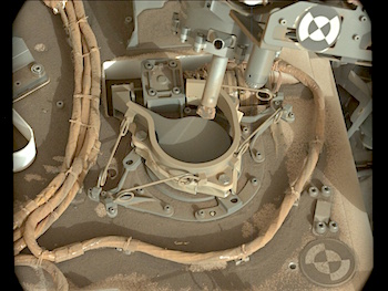
Fifteen years ago, ESA’s Mars Express was launched to investigate the Red Planet. To mark this milestone comes a striking view of Mars from horizon to horizon, showcasing one of the most intriguing parts of the martian surface.

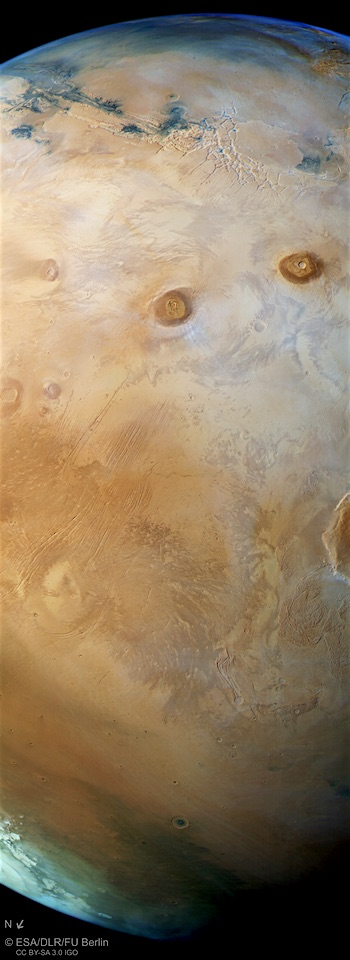
On 2 June 2003, the Mars Express spacecraft lifted off from Baikonur, Kazakhstan, on a journey to explore our red-hued neighbouring planet. In the 15 years since, it has become one of the most successful missions ever sent to Mars, as demonstrated by this image of the region known as the Tharsis province, shown here in its full glory.

Mammoth volcanoes, sweeping canyons, fractured ground: Tharsis is one of the most geologically interesting and oft-explored parts of the planet’s surface. Once an incredibly active region, displaying both volcanism and the shifting crustal plates of tectonics, it hosts most of the planet’s colossal volcanoes – the largest in the Solar System.

This view, taken by the High Resolution Stereo Camera aboard Mars Express in October 2017, shows Tharsis in all its glory.

It sweeps from the planet’s upper horizon — marked by the faint blue haze at the top of the frame — down across a web of pale fissures named Noctis Labyrinthus (a part of Valles Marineris stretching to the upper left corner of the image), Ascraeus and Pavonis Mons (two of Tharsis’ four great volcanoes at more than 20 km high), and finishes at the planet’s northern polar ice cap (in this perspective, North is to the lower left)…  [More at link, including key map and elevation map]
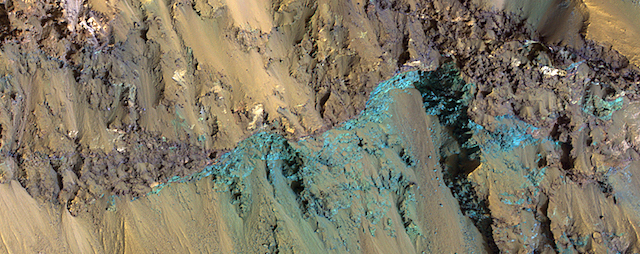
Posted in Reports | Tagged , , , , , , , , , , , , , , , | Comments Off

HiRISE: Bedrock exposed in Hale Crater’s rim

ESP_054701_1430Hale Crater is a large impact crater (more than 100 kilometers) with a suite of interesting features such as active gullies, active recurring slope lineae, and extensive icy ejecta flows. There are also exposed diverse (colorful) bedrock units.

NB: North is down, so that the slope is down to the bottom of the cutout and illumination from upper right. [More at link]

Posted in Reports | Tagged , , , , , , , | Comments Off

Curiosity: Zap goes ChemCam

2068-rmiFRB_581091290EDR_F0701752FHAZ00337M_Sol 2068, May 31, 2018. The Remote Micro-Imager follows and records the ChamCam’s laser-zapping of a target rock (above). Note how each laser shot blows the surface dust away from the resulting pit.

RRB_581091345EDR_F0701752RHAZ00337M_At right are the front and rear Hazcam views, with Duluth standing in the center. The rear view, rather noisy, looks out toward Gale Crater’s northwest rim. Click any image to enlarge it.

Sol 2068 raw images (from all cameras), and Curiosity’s latest location.

Posted in Reports | Tagged , , , , , , , , , | Comments Off

THEMIS: Winding channel in Terra Sabaea

Terra Sabaea channel (THEMIS_IOTD_20180601)THEMIS Image of the Day, June 1, 2018. The northern margin of Terra Sabaea is a complex area between a cratered highland and complexly eroded lower plains. This VIS image of the region shows just one of the numerous unnamed channels. The 90 degree bends indicate tectonic fractures have played a part in the channel formation.

More THEMIS Images of the Day by geological topic.

Posted in Reports | Tagged , , , , , , , , , | Comments Off