HiRISE: Swept away

tumblr_oqdzgi6n2C1rlz4gso1_1280
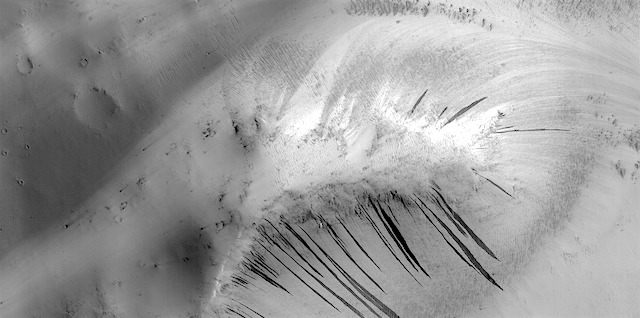
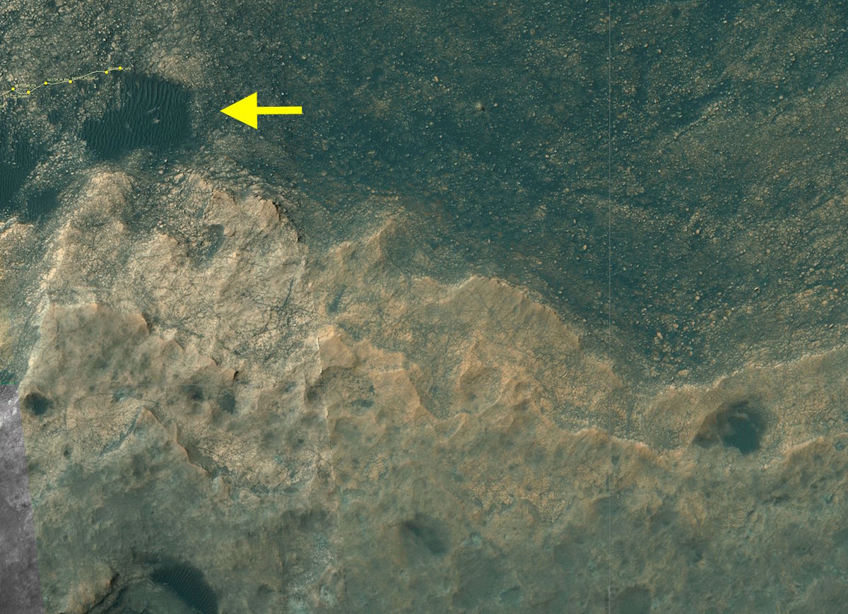
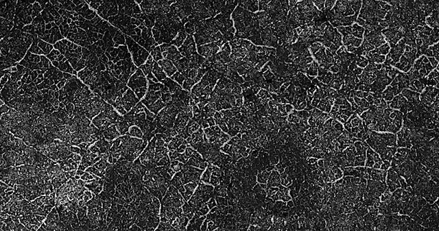
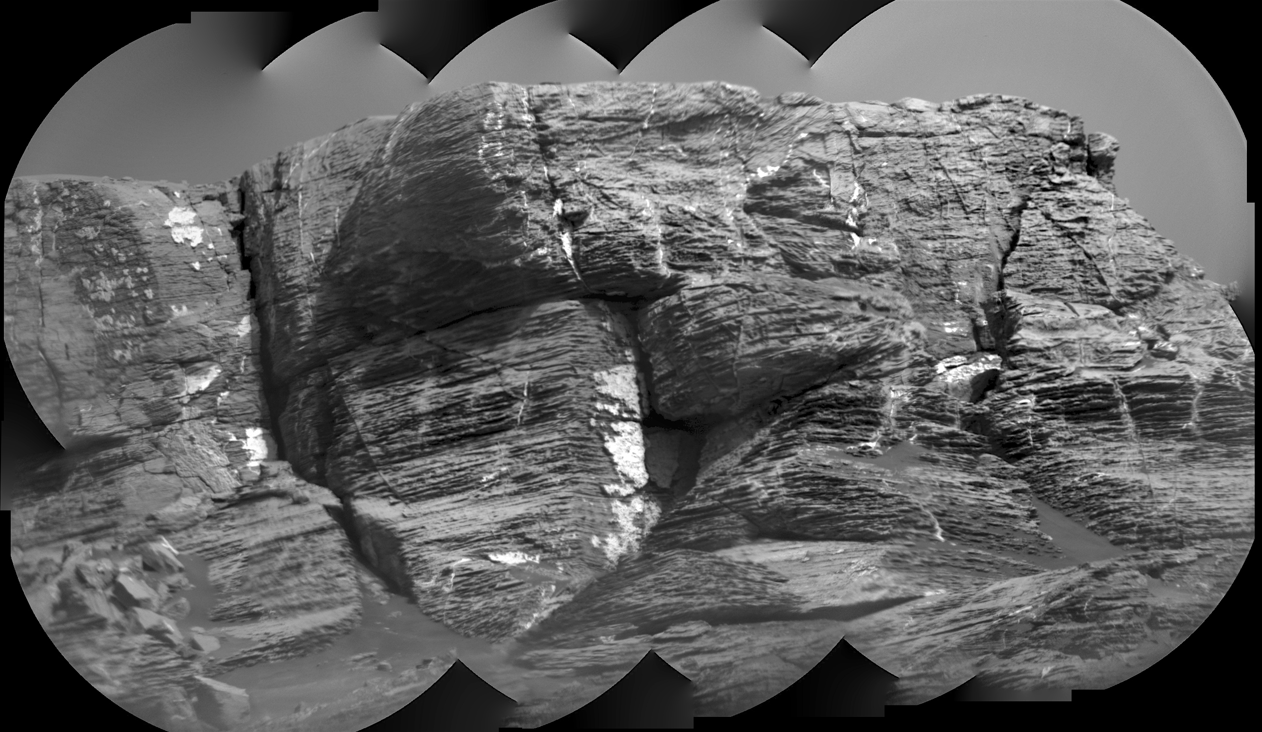
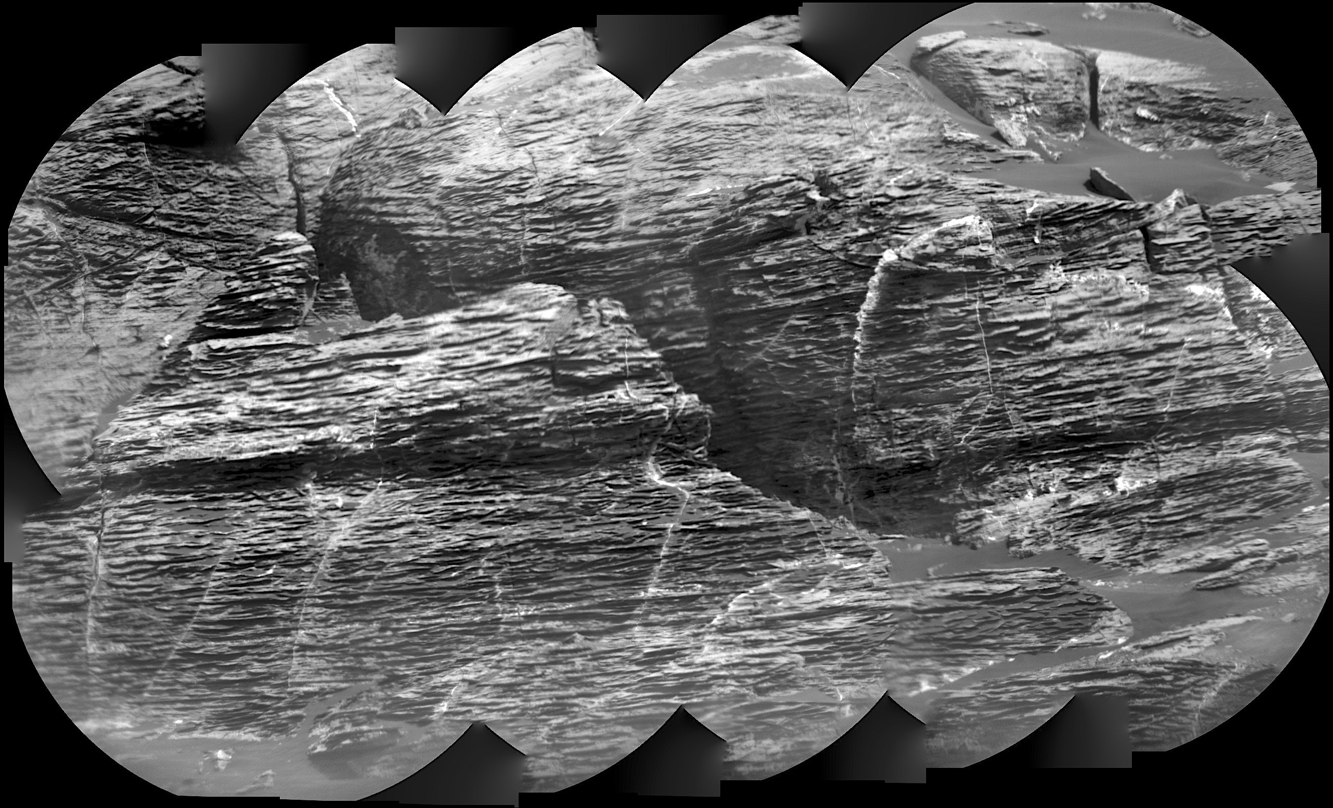
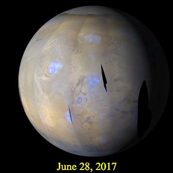
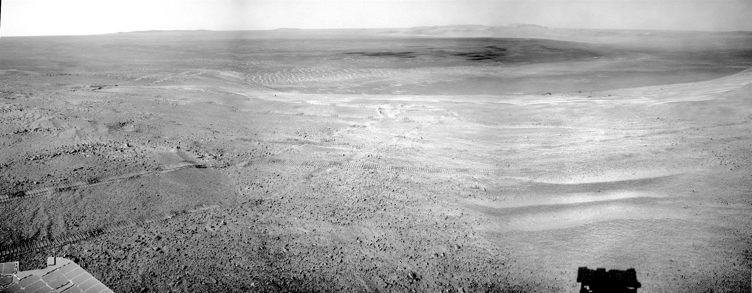
Swept away. Beautiful Mars series.

Posted in Reports | Tagged , , , , , , , , , | Comments Off

THEMIS: Russell Crater dunes in false color

Russell Crater dunes false color (THEMIS_IOTD_20170707)THEMIS Image of the Day, July 7, 2017. Today’s false color image shows part of the large dune form on the floor of Russell Crater. The bluish tint of the dunes in false color suggests that they are made of sand from basaltic rock, which is common on Mars.

The THEMIS camera contains 5 filters. The data from different filters can be combined in multiple ways to create a false color image. These false color images may reveal subtle variations of the surface not easily identified in a single band image.

More THEMIS Images of the Day by geological topic.

Posted in Reports | Tagged , , , , , , , , , , | Comments Off

Curiosity update: Martian fruit salad

NRB_552495365EDR_S0641890NCAM00252M_-br2Sol 1747, July 5, 2017, update by MSL scientist Scott Guzewich: As is typical for Curiosity lately, today we planned a “touch-and-go” suite of activities for the rover. Today I served as the Science Operations Working Group Chair. A high level of charge in Curiosity’s batteries after the long holiday weekend allowed us to prepare a bounty of science observations. The first activity was contact science, a mix of APXS and MAHLI, on a target named “Appledore” which is believed to be Murray bedrock much like we’ve examined before. This was followed by a Navcam survey for dust devils on the slopes of Mt. Sharp and then ChemCam targets on “Sugar_Plum” and “Whortleberry”, the later of… [More at link]

Posted in Reports | Tagged , , , , , , , , , , , | Comments Off

Opportunity: Sand ripples and rover tracks

4780-navcamSol 4780, July 5, 2017. Looking south toward Winnemucca mesa (skyline at center), the Navcam captures a busy-looking landscape. There are rover wheel tracks (left and right), sand ripples (foreground) shaped by winds blowing out of Endeavour Crater (left), and part of the enigmatic trough (middle distance), which mission scientists are exploring to determine its origin. (Click image to enlarge it.)

Opportunity raw images, its latest mission status, location map, and atmospheric opacity, known as tau.

Posted in Reports | Tagged , , , , , , , | Comments Off

Curiosity: Ridge skyline above, sand below

1747-navcamSol 1747, July 6, 2017. Three Navcam frames capture the skyline of Vera Rubin Ridge, as Curiosity drives east to circle around a rippled patch of sand (see below) that spreads roughly 70 meters (230 feet) wide. (Click either image to enlarge it.)

Sol 1747 raw images (from all cameras), and Curiosity’s latest location.

Curiosity_Location_Sol1741-full

Posted in Reports | Tagged , , , , , , , , | Comments Off

HiRISE: Frosted valleys

tumblr_oqdzakVxhy1rlz4gso1_1280Frosted valleys. Beautiful Mars series.

Posted in Reports | Tagged , , , , , , , , | Comments Off

THEMIS: Cimmeria’s Corozal Crater in false color

THEMIS-July-6-2017THEMIS Image of the Day, July 6, 2017. Today’s false color image shows part of Corozal Crater in Terra Cimmeria.

The THEMIS camera contains 5 filters. The data from different filters can be combined in multiple ways to create a false color image. These false color images may reveal subtle variations of the surface not easily identified in a single band image.

More THEMIS Images of the Day by geological topic.

Posted in Reports | Tagged , , , , , , , , , | Comments Off

Curiosity: Lots of layers in Vera Rubin Ridge

1745-rmi-1Sol 1745, July 4, 2017: Two 10-frame mosaics with the Remote Micro-Imager show the fine layering and details of two sections of Vera Rubin Ridge. Click either image to enlarge it.

Sol 1745 raw images (from all cameras), and Curiosity’s latest location.

1745-rmi-2

Posted in Reports | Tagged , , , , , , , , , , | Comments Off

MARCI weather report, June 26-July 2, 2017

MARCI-June-28-2017Last week on Mars, an extensive arcuate-shaped dust storm extended over eastern Acidalia before quickly subsiding near Deuteronilus. Focusing our attention further equatorwards, local-scale dust storms were frequent in the northern extratropics. The floors of the two giant impact basins, Hellas and Argyre were largely obscured by dust each sol. A couple transient dust storms were also spotted among the low latitudes, over eastern Noachis and southeast of Eos Chasma. As the aphelion cloud-belt continued to develop, regions between Olympus Mons and Meridiani Planum experienced… [More at link, including video]

Posted in Reports | Tagged , , , , , , , , , , , , , | Comments Off

Opportunity: Making tracks in the sand

4779-navcamSol 4779, July 4, 2017. As Opportunity continued its examination of the trough that aligns with Perseverance Valley, it drove 30 meters (99 feet) to the northeast. There it parked and took a Navcam three-frame composite looking generally east. Note the number of wheel tracks showing the rover’s path as it has surveyed the terrain at the head of the valley. (Click image to enlarge it.)

Opportunity raw images, its latest mission status, location map, and atmospheric opacity, known as tau.

Posted in Reports | Tagged , , , , , , | Comments Off