HiRISE: Cratered cones on northern plains

ESP_054911_2180Cratered cones on northern plains. The title alone sounds delicious. These cratered cones might be mud volcanoes, landforms created by the eruption of mud or slurries, water and gases. No lava involved.

HiRISE Picture of the Day archive. [More at links]


Posted in Reports | Tagged , , , , , , , , , , | Comments Off

THEMIS: Small graben in Acidalia Planitia

Acidalia Planitia (THEMIS_IOTD_20190617)THEMIS Image of the Day, June 17, 2019. This false-color image shows a graben located in Acidalia Planitia. Graben are depressions caused by movement of material downward between paired tectonic faults.

The THEMIS VIS camera contains 5 filters. The data from different filters can be combined in multiple ways to create a false color image. These false color images may reveal subtle variations of the surface not easily identified in a single band image.

Explore more THEMIS Images of the Day by geological subject.

Posted in Reports | Tagged , , , , , , , , , , | Comments Off

Curiosity update: An oasis of rock in a sea of pebbles

NLB_613750109EDR_F0760832NCAM00285M_-br2Sols 2437-39, June 14, 2019, update by MSL scientist Catherine O’Connell-Cooper: We are investigating the ridges which are such a prominent feature in this section of Glen Torridon. The ridges appear to be composed of sand and pebbles, capped with layered bedrock (see image above). The Rover Planners (RPs) at JPL assessed the ridge imaged, known as “Teal,” and gave a GO for driving up onto it. We broke the ascent into two drives, aiming to get halfway in yestersol’s plan (sol 2436) and the rest of the way in this weekend’s plan. The RPs got us exactly to where we wanted to be for this plan, and we ended up on a very small outcrop of more coherent bedrock, surrounded by pebbles and sand.

Those of us in the Geology theme group (GEO) were very excited to find ourselves here, as this is the most substantial piece of bedrock we have seen this week. APXS will analyze the “Iapetus” target on the bedrock, and do a 2-point raster “Almond” across small grey pebbles and sand. The rover was too close… [More at link]

Posted in Reports | Tagged , , , , , , , , , , , , , , , , , | Comments Off

Curiosity: Alongside the ridge

2436-navcamSol 2436, June 14, 2019. As scientists probe the low ridge, they are looking for rock outcrops that can tell them something of its structure and nature under the smooth, pebble-covered surface. Click the image to enlarge it.

Sol 2436 raw images (from all cameras).

Posted in Reports | Tagged , , , , , , , , , , , , , | Comments Off

Latest weather at Gale Crater and Elysium Planitia

Daily Elysium charts and data (temperature, wind speed, atmospheric pressure) here.

Posted in Reports | Tagged , , , , , , , , , , , , , , | Comments Off

Curiosity update: So many choices, so little time

2434ML0129040010902489E01_DXXX-br2Sol 2436, June 14, 2019, update by MSL scientist Michelle Minitti: The planning day started with a change of plans. Due to a late-breaking change in relay pass scheduling, the decisional pass (the communication pass carrying the latest information about Curiosity’s location and state to arrive before the start of planning on Earth the next day) in today’s plan was much earlier in the plan than we expected.

That meant that Curiosity had to wrap up her activities earlier in the sol than we initially thought. The science team had to rapidly decide how to use the limited time available for rover activities. We could choose to stay at our current position, parked along the side of a pebble-covered clay-bearing unit ridge (pictured above), for activities today and over the weekend. Or we could choose to drive off to another location for the weekend. There were many drive targets to choose from, from interesting rocks at the top of the ridge (also visible in the image above) to bedrock exposures along the base of the ridge. The science team spent a lot of time weighing the pros and cons of each target in the wider context of our study of the ridge and the clay-bearing unit. We eventually decided to drive to a small outcrop patch about 30 m away…. [More at link]

Posted in Reports | Tagged , , , , , , , , , , , , , | Comments Off

CRISM: Olivine and pyroxene in ejecta from northern plains crater

3BEECRISM scene HRL00003BEE covers an area in close proximity to a crater in the northern plains of Mars. In this image, we see strong Fe-rich olivine (yellow) and high calcium pyroxene (HCP, blue) signatures in the ejecta near the crater rim. This is indicative of mafic minerals that have been excavated by this impact crater from a depth of up to 4 km below the current surface, possibly representing previously buried ancient crust. Extensive sedimentary and volcanic deposits cover the northern lowlands of Mars dating back to the Hesperian era. Craters like this one can offer a glimpse of the composition of the…. [More at link]

Posted in Reports | Tagged , , , , , , , , | Comments Off

HiRISE: A channel in the southern mid-latitudes

ESP_054919_1465A channel in the southern mid-latitudes. The objective of this observation is to examine a channel on the eastern side of an eroded crater wall. This scene was also imaged by the Context Camera onboard MRO.

HiRISE Picture of the Day archive. [More at links]

Posted in Reports | Tagged , , , , , , , , , | Comments Off

Remote-sensing mast installed on 2020 rover

PIA23267_hires
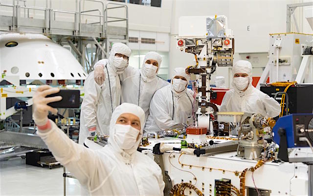
In this image, taken on June 5, 2019, engineers at NASA’s Jet Propulsion Laboratory in Pasadena, California, take a moment after attaching the remote sensing mast to the Mars 2020 rover in the Spacecraft Assembly Facility’s High Bay 1 clean room. Full integration of the mast – a process that includes installation of science instrument sensors, electrical wiring and checkout – continued into the following week, concluding on June 11.

During Mars 2020′s launch, interplanetary cruise, and its fast and fiery descent toward the Martian surface, the mast will be in stowed flat on the rover’s deck. Soon after touchdown, the mast (which tops out at over 7 feet, or 2.2 meters) will be raised to provide a high perch for the SuperCam, Mastcam-Z and Mars Environmental Dynamics Analyzerinstruments as well as four Navcam engineering cameras. [More at link]
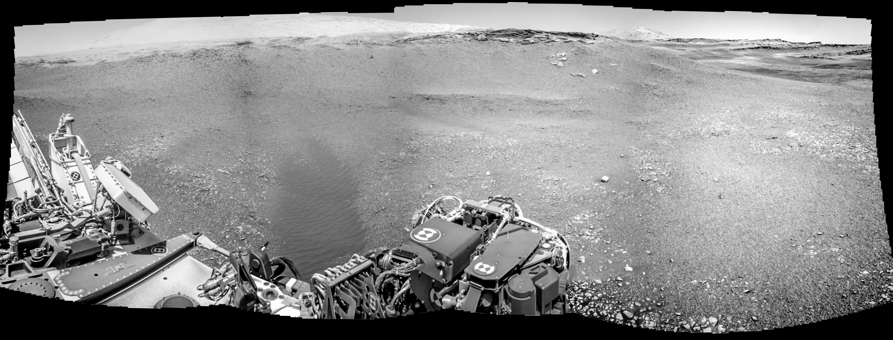
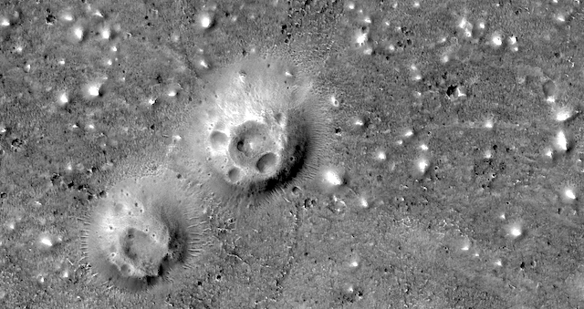
Posted in Reports | Tagged , , , , , , | Comments Off

THEMIS: South polar layers

South polar layers swirl (THEMIS_IOTD_20190614)THEMIS Image of the Day, June 14, 2019. This VIS image shows part of the south polar cap. The numerous layers that comprise the polar cap are readily visible. The cap was built up over millions of years of deposition of ice and dust.

Explore more THEMIS Images of the Day by geological subject.

Posted in Reports | Tagged , , , , , , , , , , , | Comments Off