Curiosity: At the waypoint ridge

2435-navcam
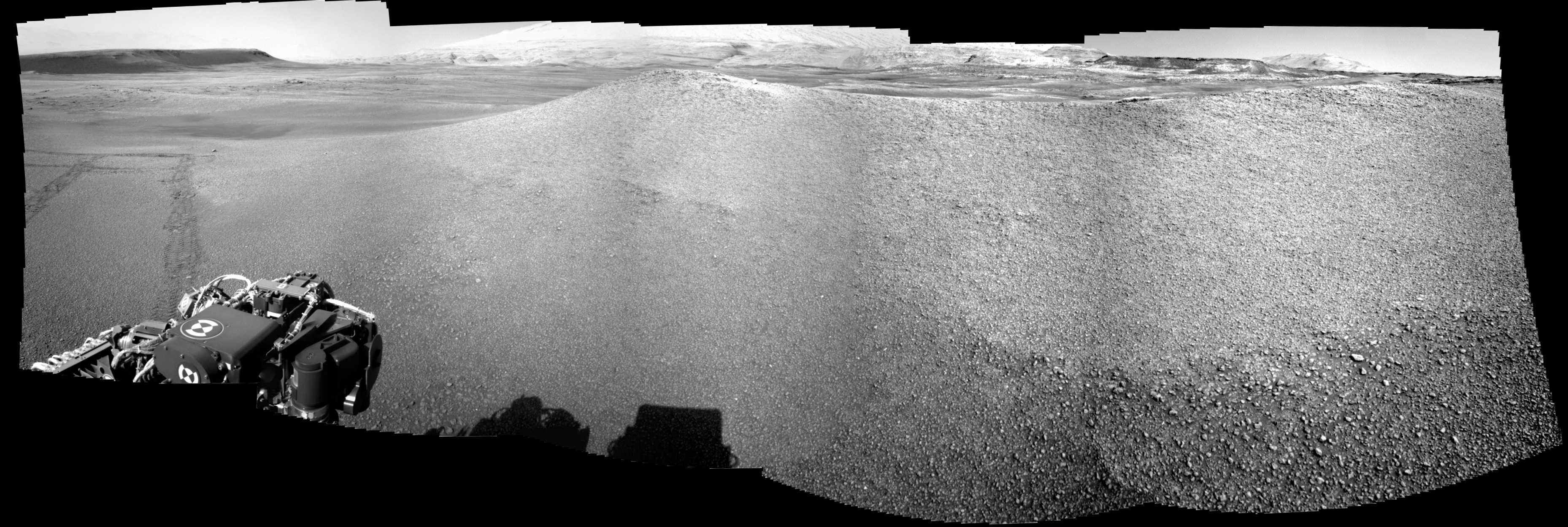
Sol 2435, June 13, 2019. The ridge at Waypoint 4 is the latest stop for Curiosity. As detailed here, the ridge is of geological interest because its origin is unclear to mission scientists and may shed light on the Glen Torridon clay-bearing unit. The Navcam view above combines five frames; click the image to enlarge it.

Sol 2435 raw images (from all cameras).

Posted in Reports | Tagged , , , , , , , , , , , , , | Comments Off

Mars’ water-ice clouds thicken toward evening

figure_10[Editor’s note: From a paper by Michael Smith recently published in Icarus.]

Local time variation of water ice clouds on Mars as observed by THEMIS

• The local time variation of cloud optical depth is examined from THEMIS observations.
• Clouds have higher optical depth during the evening than earlier in the afternoon.
• After sunset, clouds expand to locations where clouds were not present earlier.

The move of the Odyssey spacecraft during Mars Years 31 and 32 to an orbit with local time near 7:00 AM and PM has enabled the systematic retrieval of water ice cloud optical depth using THEMIS thermal infrared images at a time of day not accessible from Mars Global Surveyor, Mars Reconnaissance Orbiter, or previous Odyssey observations.

Because water ice clouds form by condensation, relatively small changes in atmospheric temperature can cause clouds to form or sublimate quickly, and there can be large changes in water ice cloud optical depth over the course of a day.

Retrievals of water ice cloud optical depth using THEMIS observations show significant differences in cloud locations and optical depth as a function of local time and season. Cloud optical depth generally increases from the earliest (14:30) to latest (19:30) observations.

During the aphelion season the increase from afternoon to evening is primarily associated with the thickening of existing clouds, while during the equinoctial and perihelion seasons there is a proportionally greater increase associated with the formation of clouds in the evening at locations where clouds were not present during the afternoon. [More at link]

Posted in Reports | Tagged , , , , , , , , , | Comments Off

Curiosity update: Forecast: it’s pebbly out there

FRB_613583123EDR_F0760568FHAZ00302M_-br2Sol 2435, June 13, 2019, update by MSL scientist Susanne Schwenzer: After yesterday’s soliday for the rover operations team on Earth, we went back to work planning activities for Curiosity to complete on sol 2435 in the Glen Torridon area. One feature standing high above the ground in this area are ridges, displaying a mixture of pebbles and sand. Their surface appears to be compacted enough to drive over, but finding a target suitable for our chemistry investigations is a challenge – unless we want soil, of course. It is nevertheless important to understand the chemistry of the pebbles since they do originate from a rock that makes up the stratigraphy of the Gale sediment column. Thus, understanding their composition is as important as understanding outcrops and bigger float rocks.

The team planned a series of investigations of the pebbles and the soil in between. We are also looking into the distance, but more about that later. The investigations at the current parking location are two ChemCam investigations. The target “Little Minch” is a pebble of about 2 to 3 cm size. The ChemCam team managed to fit a five-spot raster on it. Next to the pebble, a second ChemCam investigation targets… [More at link]

Posted in Reports | Tagged , , , , , , , , , , , , , , , , | Comments Off

HiRISE: Landing in Oxia Palus

ESP_060015_1980This image shows a cratered area to the southeast of the ExoMars 2020 Rosalind Franklin rover landing site at Oxia Palus.

Selecting and characterizing landing sites is a balance between having science targets and avoiding potential obstacles, and HiRISE is used for both purposes.

Craters like this one excavate material from within the crust, including both sedimentary and igneous rocks, and scatter this material far from the crater itself. This is one of the ways that so-called “float rocks” (rocks that are not connected to their original outcrop) can occur across a landing site: they are often ejecta from distant impacts.

Here, an ejecta blanket is visible in the rays of material surrounding this 2-kilometer diameter crater. The ExoMars rover has a suite of cameras and a close-up imager (called CLUPI) that will be used to study these float rocks. Studying such samples has been an important way of learning about the deep crust of Mars on previous missions, notably the Spirit and Opportunity rovers and now, Curiosity. [More at link]

Posted in Reports | Tagged , , , , , , , , , , , , , , , | Comments Off

New model for martian crustal magnetism

figure_8[Editor’s note: From a paper by Benoit Langlais and four co-authors recently published in the Journal of Geophysical Research.]

A New Model of the Crustal Magnetic Field of Mars Using MGS and MAVEN

• MGS and MAVEN magnetic field measurements are combined into a high‐resolution magnetic field model
• The new model extends up to SH degree 134, corresponding to 160‐km horizontal resolution at the Martian surface
• It enables local studies, where geologic and magnetic features can be compared

While devoid of an active magnetic dynamo field today, Mars possesses a remanent magnetic field that may reach several thousand nanoteslas locally. The exact origin and the events that have shaped the crustal magnetization remain largely enigmatic.

Three magnetic field data sets from two spacecraft collected over 13 cumulative years have sampled the Martian magnetic field over a range of altitudes from 90 up to 6,000 km: (a) Mars Global Surveyor (MGS) magnetometer (1997–2006), (b) MGS Electron Reflectometer (1999–2006), and (c) Mars Atmosphere and Volatile EvolutioN (MAVEN) magnetometer (2014 to today).

In this paper we combine these complementary data sets for the first time to build a new model of the Martian internal magnetic field. This new model improves upon previous ones in several aspects: comprehensive data coverage, refined data selection scheme, modified modeling scheme, discrete‐to‐continuous transformation of the model, and increased model resolution.

The new model has a spatial resolution of ∼160 km at the surface, corresponding to spherical harmonic degree 134. It shows small scales and well‐defined features, which can now be associated with geological signatures. [More at link]

Posted in Reports | Tagged , , , , , , , , | Comments Off

THEMIS: Tectonic traces in Amenthes Fossae

Amenthes Fossae (THEMIS_IOTD_20190613)THEMIS Image of the Day, June 13, 2019. The two linear depressions crossing this VIS image are graben created by tectonic activity.

Explore more THEMIS Images of the Day by geological subject.

Posted in Reports | Tagged , , , , , , , , , | Comments Off

MARCI weather report, June 3-9, 2019

MARCI-June-8-2019Last week on Mars, dust storm activity continued along the edge of the receding seasonal north polar ice cap. Near the beginning of the week, a regional-scale dust storm occurred over the eastern Arcadia region and spread both southward to Amazonis and eastward towards the plains of Acidalia. As the storm slowly subsided during the second half of the week, dust haze pushed south towards the flanks of Olympus Mons. Focusing our… [More at link, including video]

Posted in Reports | Tagged , , , , , , , , , , , , , , | Comments Off

Curiosity update: Ridge rage

NRB_613396375EDR_F0760274NCAM00279M_-br2Sol 2434, June 10, 2019, update by MSL scientist Mariah Baker: It’s a good thing that Curiosity doesn’t have any competition on the road as she drives fervently across undulating terrain towards a large geologic ridge of unknown origin (informally named “Waypoint 4″). The weekend plan included a long 44-meter drive to put her in her current location (on a similar, but smaller ridge), and two more 25-meter drives were planned for this week to put her at a good vantage point for imaging the side of the ridge. But the team decided to put the pedal to the metal and try to make it to this ridgeline in just one drive. Ridge features are common throughout the Glen Torridon unit, so characterizing the morphology and chemical composition of these ridges can place important constraints on their formation and on the overarching geologic history of this region. This will be the goal of our investigation at Waypoint 4…. [More at link]

Posted in Reports | Tagged , , , , , , , , , , , , , , | Comments Off

Mars 2020 rover to blaze trail for humans

PIA23302_hiresWhen a female astronaut first sets foot on the Moon in 2024, the historic moment will represent a step toward another NASA first: eventually putting humans on Mars. NASA’s latest robotic mission to the Red Planet, Mars 2020, aims to help future astronauts brave that inhospitable landscape.

While the science goal of the Mars 2020 rover is to look for signs of ancient life – it will be the first spacecraft to collect samples of the Martian surface, caching them in tubes that could be returned to Earth on a future mission – the vehicle also includes technology that paves the way for human exploration of Mars.

The atmosphere on Mars is mostly carbon dioxide and extremely thin (about 100 times less dense than Earth’s), with no breathable oxygen. There’s no water on the surface to drink, either. The landscape is freezing, with no protection from the Sun’s radiation or from passing dust storms. The keys to survival will be technology, research and testing.

Mars 2020 will help on all those fronts. When it launches in July of 2020, the spacecraft will carry the latest scientific and engineering tools, which are coming together as the rover is built at NASA’s Jet Propulsion Laboratory in Pasadena, California. Here’s a closer look… [More at link]

Posted in Reports | Tagged , , , , , , , , , , , , | Comments Off

Latest weather at Gale Crater and Elysium Planitia

Daily Elysium charts and data (temperature, wind speed, atmospheric pressure) here.

Posted in Reports | Tagged , , , , , , , , , , , , , , | Comments Off