


-
Recent Posts
Archives
Links
general
mission instruments
- CRISM: Compact Reconnaissance Imaging Spectrometer for Mars
- CTX: Context Camera
- HiRISE: High Resolution Imaging Science Experiment
- MARSIS: Mars Advanced Radar for Subsurface and Ionosphere Sounding
- SHARAD: Shallow Radar
- THEMIS: Thermal Emission Imaging System
missions
- All Mars missions list
- Curiosity rover
- ExoMars
- Hope (al-Amal) orbiter
- InSight
- Mars Atmosphere and Volatile Evolution Mission (MAVEN)
- Mars Exploration Rovers (MER)
- Mars Express (MEX)
- Mars Odyssey
- Mars Orbiter Mission (MOM) / Mangalyaan
- Mars Reconnaissance Orbiter (MRO)
- Mars Science Laboratory (MSL)
- Perseverance Rover
- Tianwen-1 orbiter/rover
news
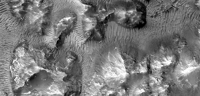
HiRISE: Aram Chaos
Posted in Reports
Tagged Aram Chaos, Beautiful Mars, chaos, chaotic terrain, High Resolution Imaging Science Experiment, HiRISE, Mars Reconnaissance Orbiter, MRO, NASA, University of Arizona
Comments Off
THEMIS: Fragments of a climate history book
 THEMIS Image of the Day, May 8, 2017. Today’s VIS image shows layered material near the south polar cap. Such layers contain a detailed, if partial, history of the martian climate. Scientists would love to read this “book,” however fragmentary, both for what it says about Mars and for comparisons with Earth.
More THEMIS Images of the Day by geological topic.
Posted in Reports
Tagged Arizona State University, ASU, Mars Odyssey, NASA, south polar ice cap, south polar layered deposits, THEMIS, THEMIS Image of the Day, Thermal Emission Imaging System
Comments Off
Curiosity carries dune-sand sample, as team works on drill-feed problem
 As it drives uphill from a band of rippled sand dunes, NASA’s Curiosity Mars rover is toting a fistful of dark sand for onboard analysis that will complete the rover’s investigation of those dunes.
From early February to early April, the rover examined four sites near a linear dune for comparison with what it found in late 2015 and early 2016 during its investigation of crescent-shaped dunes. This two-phase campaign is the first close-up study of active dunes anywhere other than Earth.
Among the questions this Martian dune campaign is addressing is how winds shape dunes that are relatively close together, on the same side of the same mountain, into different patterns. Others include whether Martian winds sort grains of sand in ways that affect the distribution of mineral compositions, which would have implications for studies of Martian sandstones.
“At these linear dunes, the wind regime is more complicated than at the crescent dunes we studied earlier,” said Mathieu Lapotre of Caltech, in Pasadena, California, who helped lead the Curiosity science team’s planning for the dune campaign. “There seems to be more contribution from the wind coming down the slope of the mountain here compared with the crescent dunes farther north.” [More at link]
Posted in Reports
Tagged Aeolis Mons, Bagnold Dunes, Curiosity, Gale Crater, Mars Science Laboratory, Mount Sharp, MSL, Murray Formation, NASA
Comments Off
Opportunity: Ripples in the ‘spillway’
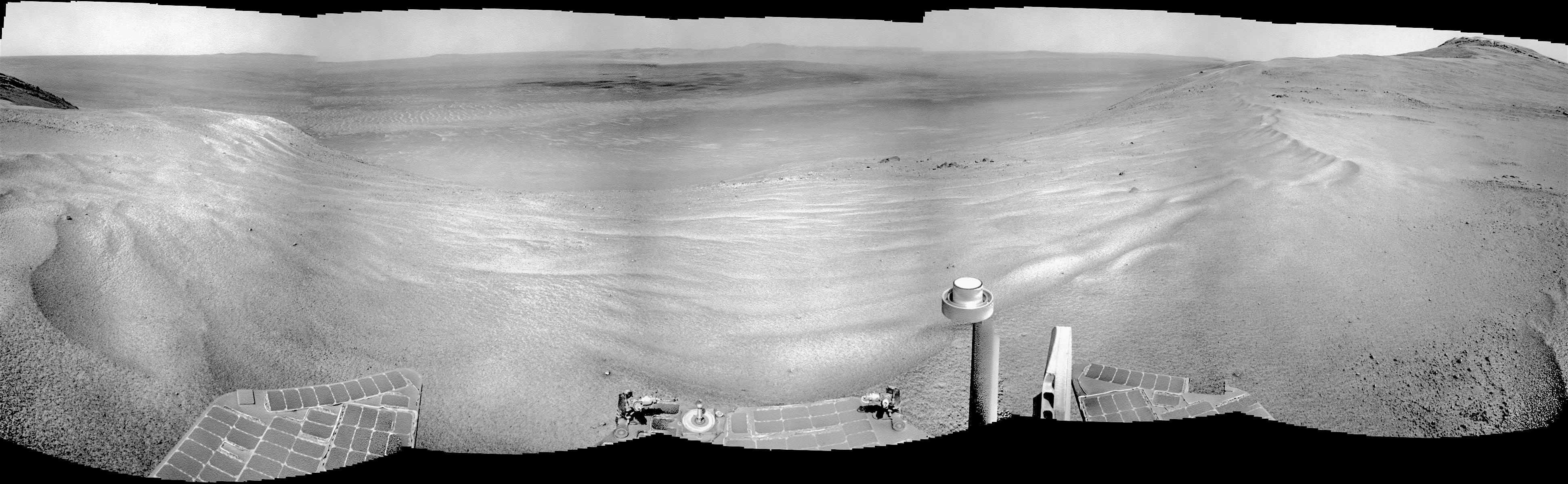 Sol 4720, May 4, 2017. After a 12-meter (40-foot) drive, Opportunity is at the “spillway” that marks the entrance to Perseverance Valley. Sand ripples spread across the rover’s path, perhaps piled up by easterly winds blowing out of Endurance Crater.
The valley’s upper slope is hiding most of the terrain ahead, but HiRISE observations have given rover drivers a measure of how steep the valley descends. Yet the slippage that occurred in places as Opportunity climbed up the east face of Cape Tribulation is a reminder that good traction on martian slopes should not be taken for granted.
It’s likely the rover team will make downhill images from both sides of the valley entrance. This will produce stereo images to let them build a 3-D map of the valley to pick the safest route into it, and eventually down to the crater floor. Click the image to enlarge it.
Opportunity raw images, its latest mission status, a location map, and atmospheric opacity, known as tau.
Posted in Reports
Tagged Cape Byron, Cape Tribulation, Endeavour Crater, Mars Exploration Rover, MER, NASA, Opportunity, Perseverance Valley, Winnemucca
Comments Off
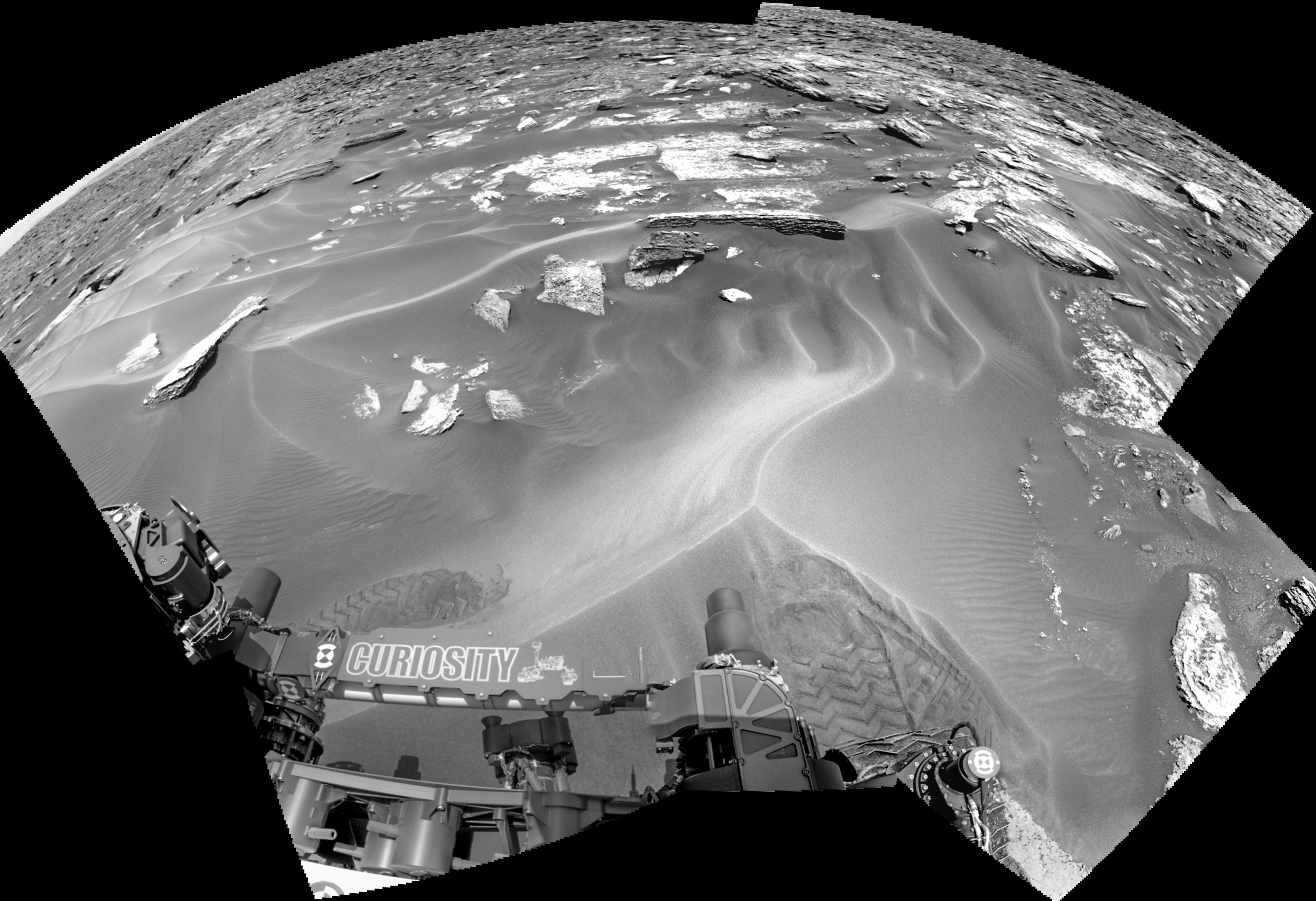
Curiosity update: Mega-science at a megaripple!
 Sol 1687, May 5, 2017, update by MSL scientist Michelle Minitti: The rover planners executed another great drive to park us in front of a megaripple in order to study its physical and chemical characteristics, which we can compare and contrast to the sands we investigated during our recent Bagnold dune campaign.
As the geology (GEO) theme group lead today, my job was to make sure we planned the highest priority observations of the megaripple, and positioned ourselves to successfully complete all the desired observations of the megaripple in the upcoming weekend plan. Working with my fellow GEO group members and all the individual instrument teams is one of the most satisfying parts of the job, as everyone brings their experience and capabilities together to build a plan that gets the most science out of the rover each sol. We certainly put Curiosity to work, planning MAHLI and APXS observations of the target “Schoolhouse… [More at link]
Posted in Reports
Tagged Aeolis Mons, Amphitheater Valley, Bagnold Dunes, Cobbosseecontee Lake, Curiosity, Gale Crater, Gilpatrick Ledge, Man of War Brook, Mars Science Laboratory, Mount Sharp, MSL, Murray Formation, NASA, Schoolhouse Ledge, The Gorge
Comments Off
HiRISE: Layers along a mesa in Hellas Planitia
Posted in Reports
Tagged Hellas Planitia, layered deposits, layers, mesas, sedimentary debris
Comments Off
THEMIS: Dune sheet in Proctor Crater
 THEMIS Image of the Day, May 5, 2017. Today’s false color image shows part of the sand sheet with surface dune forms located on the floor of Proctor Crater. Proctor Crater is located in Noachis Terra.
The THEMIS VIS camera contains 5 filters. The data from different filters can be combined in multiple ways to create a false color image. These false color images may reveal subtle variations of the surface not easily identified in a single band image.
More THEMIS Images of the Day by geological topic.
Posted in Reports
Tagged Arizona State University, ASU, dunes, Mars Odyssey, NASA, Noachis Terra, Proctor Crater, sand dunes, sand sheets, THEMIS, THEMIS Image of the Day, Thermal Emission Imaging System
Comments Off
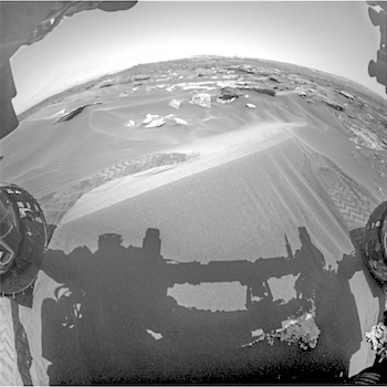
Curiosity: Among megaripples
 Sol 1686, May 4, 2017. Curiosity’s drive toward Vera Rubin Ridge is encountering locations where sand has collected into large ripples. Here we see that the rover rolled a foot or two onto a ripple then rolled back, perhaps as rover drivers tested the sand’s trafficability. Click image to enlarge it.
Sol 1686 raw images (from all cameras), and Curiosity’s latest location.
Posted in Reports
Tagged Aeolis Mons, Bagnold Dunes, Curiosity, Gale Crater, Mars Science Laboratory, Mount Sharp, MSL, Murray Formation, NASA, sand ripples, Vera Rubin Ridge
Comments Off
Opportunity report, Sol 4716, by A.J.S. Rayl, The Planetary Society
 so the MER scientists can better see the geology and what appear to be channels that appear to emanate from it.") May 3, 2017: Opportunity closes in on Perseverance Valley: Opportunity spent the month of April 2017 outside the western rim of Endeavour Crater, cruising toward Cape Byron and Perseverance Valley, the centerpiece of the Mars Explorations Rovers (MER) tenth extended mission.
May 3, 2017: Opportunity closes in on Perseverance Valley: Opportunity spent the month of April 2017 outside the western rim of Endeavour Crater, cruising toward Cape Byron and Perseverance Valley, the centerpiece of the Mars Explorations Rovers (MER) tenth extended mission.
The veteran robot field geologist worked hard to pick up the pace during the last month, logging 10 drives and covering about a quarter of a mile. “We are now within striking distance of Perseverance Valley,” said MER Project Manager John Callas, of the Jet Propulsion Laboratory (JPL), at April’s end. (…)
“There is a building excitement,” said MER Deputy Principal Investigator Ray Arvidson, of Washington University St. Louis. “It won’t be long now before we will be looking into Perseverance Valley.”
After being confined to roving around in relatively small areas compared to the open expanse of the Meridiani Plains that she spent so many years crossing, Opportunity and her drivers finally had the chance in April to put pedal to the metal and just drive. “We’ve been making astonishing progress,” said MER Rover Planner Ashley Stroupe, of JPL, the birthplace of all NASA’s Mars rovers. “We’ve been on much smoother terrain and it’s been much easier to drive.”
In fact, on one drive Opportunity sprinted for more than 130 meters (about 430 feet) in a dash the likes of which she hadn’t done probably since leaving Cape York about four years ago. It made drivers on Curiosity duty, well, a little envious.
“It was a heck of a drive,” said MER Lead Flight Director Mike Seibert, of JPL, who split driving shifts that day with MER Rover Planner Paolo Bellutta, the rover robotics expert who has charted Opportunity’s routes since Victoria Crater. “The driving has been going incredibly well,” he concluded.
Averaging two to three drives each week, Opportunity, by all accounts, made impressive progress to Perseverance Valley while also taking care of the other routine business of roving Mars, and packing in a few science investigations along the way. One outcrop puzzled the science team, being, as it turned out, bedrock with a somewhat familiar composition, but one that did not neatly match any strata the mission has found so far. “Mars still surprises us,” said Arvidson. [More at link]
Posted in Reports
Tagged Cape Byron, Endeavour Crater, Mars Exploration Rover, MER, NASA, Opportunity, Perseverance Valley
Comments Off
HiRISE: Seasonal flows in Valles Marineris
 Recurring slope lineae (RSL) are seasonal flows on warm slopes, and are especially common in central and eastern Valles Marineris. This image covers a large area full of interesting features, but the enhanced color closeup highlight some of the RSL.
Here, the RSL are active on east-facing slopes, extending from bouldery terrain and terminating on fans. Perhaps the fans themselves built up over time from the seasonal flows. Part of the fans with abundant RSL are dark, while the downhill portion of the fans are bright. The role of water in RSL activity is a matter of active debate. [More at link]
Posted in Reports
Tagged High Resolution Imaging Science Experiment, HiRISE, Mars Reconnaissance Orbiter, MRO, NASA, recurring slope lineae, RSL, University of Arizona, Valles Marineris
Comments Off