HiRISE: Dune footprints in Hellas Planitia

ESP_059708_1305
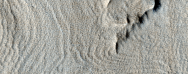
These curious chevron shapes in southeast Hellas Planitia are the result of a complex story of dunes, lava, and wind.

Long ago, there were large crescent-shaped (barchan) dunes that moved across this area, and at some point, there was an eruption. The lava flowed out over the plain and around the dunes, but not over them. The lava solidified, but these dunes still stuck up like islands. However, they were still just dunes, and the wind continued to blow. Eventually, the sand piles that were the dunes migrated away, leaving these “footprints” in the lava plain. These are also called “dune casts” and record the presence of dunes that were surrounded by lava.

Enterprising viewers will make the discovery that these features look conspicuously like a famous logo: and you’d be right, but it’s only a coincidence. [More at link]

Posted in Reports | Tagged , , , , , , , , , , , | Comments Off

THEMIS: The graben of Ceraunius Fossae

Ceraunius Fossae graben (THEMIS_IOTD_20190612)THEMIS Image of the Day, June 12, 2019. This VIS image shows part of Cerunius Fossae. The linear depressions are fault bounded features called graben.

These features form from tectonic forces that are pulling apart the surface, created space for material to “slide down” along the fault. Here the tectonic stress comes from a large, but low, volcanic feature named Alba Mons.

Explore more THEMIS Images of the Day by geological subject.

Posted in Reports | Tagged , , , , , , , , , | Comments Off

Curiosity: Roving the clay-enriched plains

2432-navcamSol 2432, June 10, 2019. After a lengthy drive across the pebbled surface, Curiosity is parked near low outcroppings of bedrock. Click either image to enlarge it.

Sol 2432 raw images (from all cameras).

2432-navcam2


Posted in Reports | Tagged , , , , , , , , , , , | Comments Off

HiRISE: Rhythmic layers east of Medusae Fossae

ESP_057092_1770The surface of this image looks wavy, like that of the sea. These wave shapes are the result of erosion: the removal of material, which has been ongoing for millions, if not billions, of years. This erosion is likely performed by the action of wind and has revealed layered rock that was deposited in this area in the ancient past.

The layers were deposited very regularly one on top of another and the erosion has cut across them—sometimes shallowly, sometimes more deeply—to create these giant undulations. More resistant layers protrude further, making them the visible crests of the waves. [More at link]

Posted in Reports | Tagged , , , , , , , , | Comments Off

THEMIS: Rough ground in Nilosyrtis

Rough ground in Nilosyrtis (THEMIS_IOTD_20190611)THEMIS Image of the Day, June 11, 2019. Today’s VIS image is located on the margin of the Terra Sabaea highlands and the Nilosyrtis Mensae lowlands. The drop off is very steep – about 18,000 ft.

This “edge” circles the northern hemisphere of Mars and is called the crustal dichotomy. The process that created this dichotomy is unknown. In the transition region, the highlands break up into mesas and valleys, like those seen in this image.

The striations in the valley floors suggest that they are filled with glacier ice that flowed at one time.

Explore more THEMIS Images of the Day by geological subject.

Posted in Reports | Tagged , , , , , , , , , , , , | Comments Off

Curiosity update: Punctuated sleep for Curiosity

NRB_613140598EDR_F0760000NCAM00277M_-br2Sols 2431-33, June 8, 2019, update by MSL scientist Mark Salvatore: After yesterday’s 47 meter drive, Curiosity awoke to a much different landscape than she had been analyzing over the past week. Instead of the beautifully exposed sedimentary bedrock that had been extensively analyzed since late May, Curiosity now finds herself among a pile of small pebbles and cobbles intermixed with sand.

While this landscape doesn’t allow for brushing of any of these small rocks, Curiosity will still perform some high-resolution microscopic imaging and some bulk chemical analyses using both the ChemCam and APXS instruments on nearby targets to characterize the local cobbles and soils. The following morning, Curiosity will conduct a series of environmental observations using ChemCam and Mastcam before embarking on a ~40 meter drive. Once Curiosity arrives at this new location… [More at link]

Posted in Reports | Comments Off

HiRISE: Tooting Crater ejecta

ESP_057013_2045In this picture we can see a huge tongue-like form, which looks a like a mudflow with boulders on its surface. This “tongue” is only a small part of a larger deposit that completely surrounds Tooting Crater (not visible in this image). This is part of what is called an “ejecta blanket.”

The shape and form of the deposits in the ejecta blanket can tell us about the condition of the ground when the impact crater was formed. The presence of this tongue of ejecta is interpreted as a sign that the ground was frozen before impact. The force of the impact melted ice and mixed it with rock and dust as it was thrown away from the crater. It then settled to form these tongue-like lobes all around the crater. [More at link]

Posted in Reports | Tagged , , , , , , , , , | Comments Off

Curiosity: Makin’ tracks

2429-mastcam34RRB_613207361EDR_F0760000RHAZ00341M_Sols 2429-30, June 7, 2019. After driving 47 meters (154 feet) east, Curiosity halted and mission controllers directed the Mastcam (34mm lens) to shoot a five-frame composite looking forward (above).

The next (martian) day, the right-side Hazcams shot the scene ahead and behind from the same place, with the rear view showing the rover’s tracks. (All three images enlarge when clicked.)FRB_613207327EDR_F0760000FHAZ00341M_

Sol 2430 raw images (from all cameras).

Posted in Reports | Tagged , , , , , , , , , , | Comments Off

HiRISE: Wisps

ESP_054916_1660Wisps. This rough terrain with prominent, wispy dust streaks is within Mangala Valles. Mangala Valles is a complex system of criss-crossing channels on Mars, located in the Tharsis region.

HiRISE Picture of the Day archive. [More at links]

Posted in Reports | Tagged , , , , , , , , , , | Comments Off

THEMIS: Summit caldera of Arsia Mons

Summit caldera of Arsia Mons (THEMIS_IOTD_20190610)THEMIS Image of the Day, June 10, 2019. Today’s VIS image shows part of the summit caldera of Arsia Mons. Arsia Mons is the southernmost of the three large Tharsis volcanoes. Extensive lava plains originated from eruptions of this volcano.

On the left side of the image are two hills with linear depressions at the top. These features are vents where localized eruptions created small volcanoes.

Explore more THEMIS Images of the Day by geological subject.

Posted in Reports | Tagged , , , , , , , , , , , | Comments Off