


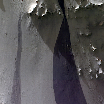
 Consider the slope streak; and his faded friend. (North is approximately down).
Beautiful Mars series.
Consider the slope streak; and his faded friend. (North is approximately down).
Beautiful Mars series.
 Sol 1575, January 9, 2017, update by USGS scientist Ken Herkenhoff: After a 25-meter drive on Sol 1574, MSL again has bedrock exposed in her arm workspace. To balance desires to sample the composition of the rocks along the traverse and to make good progress toward the south, contact science and another drive are both planned for Sol 1575. First, MAHLI will acquire a full suite of images of a knobbly bedrock target named “Dorr Mountain.” Then the arm will be stowed to allow ChemCam to observe the same target and for dust devils before the… [More at link]
 THEMIS Image of the Day, January 10, 2017. Today’s VIS image shows part of Noachis Terra, including several large dunes on the floor of an unnamed crater. These dunes are dark in tone, hence free of the light dust that’s everywhere on Mars. This strongly suggests the dunes are responding to the blowing wind.
More THEMIS Images of the Day by geological topic.
 The western Utopia Planitia in the Northern mid-latitudes of Mars is marked by a peculiar type of depression with scalloped edges and by a network of polygonal fractures.
The scalloped depressions are typical features; a smooth layered terrain located between 40 and 60 degrees in both hemispheres. Scalloped depressions probably form by removal of ice-rich subsurface material by sublimation (ice transforming directly from a solid to a gaseous state), a process that may still be active today. Isolated scalloped depressions generally… [More at link]
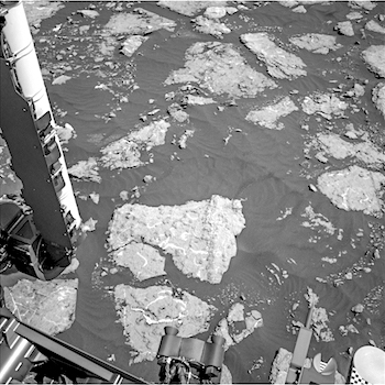
 Sol 1574, January 9, 2017. The rover put 26 meters (85 feet) behind it as Curiosity drove southeast, continuing its trek toward Mt. Sharp. Around here, sand covers about as much of the ground as rocks do. Above, the right front Hazcam shoots the scene at local noon, with Mt. Sharp rising on the left and the low, dark butte of Ireson Hill visible on the right in the distance. Click image to enlarge it.
Sol 1574 raw images (from all cameras), and Curiosity’s latest location.

 Sol 4607, January 8, 2017. Opportunity drove about 13 meters (41 feet) to the northeast, as mission controllers directed the rover toward what should prove to be firmer ground for ascending the slope. The view above (1.7 MB) looks upslope, with Beacon Rock at left.
But before driving away from the soft-ground targets Sibley and Missouri City, the Pancam took multi-band image of the disturbed area (right); false-color by Holger Isenberg. Both images enlarge when clicked.
Opportunity raw images, its latest mission status, a location map, and atmospheric opacity, known as tau.
 Putative chloride deposit in the Ladon Valles basin. Beautiful Mars series.
 THEMIS Image of the Day, January 9, 2017. Today’s VIS image shows some of the extensive wind etched terrain in Memnonia Sulci, located south west of Olympus Mons. The linear ridges are called yardangs and form by wind removal of semi-cemented material. The ridges are parallel to wind direction, so the predominate winds that created the yardangs in this image blew NW/SE. At the bottom of the image several of the ridges have been eroded into smaller ridges aligned perpendicular to the large yardangs, indicating winds at a different angle.
More THEMIS Images of the Day by geological topic.
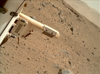 Sol 1572-74, January 6, 2017, update by USGS scientist Ken Herkenhoff: MSL drove nearly 17 meters on Sol 1571, to a location with bedrock outcrops in the arm workspace. So the weekend plan includes lots of arm work as well as remote observations. On Sol 1572, MAHLI will take images of the REMS booms to diagnose recent problems with the wind sensors. Some of the wind sensors on one boom have not functioned since landing, and sensors on the other boom have been acting up lately. Later that afternoon, MAHLI will take a couple images of a yellow/red color boundary at “Greenstone” and a full suite of images of a yellow bedrock target named “Isle Au Haut.” The APXS will then be placed on Isle Au Haut for an overnight integration. Early on the morning of Sol 1573, Navcam will search for clouds and Mastcam will measure the amount of dust… [More at link]
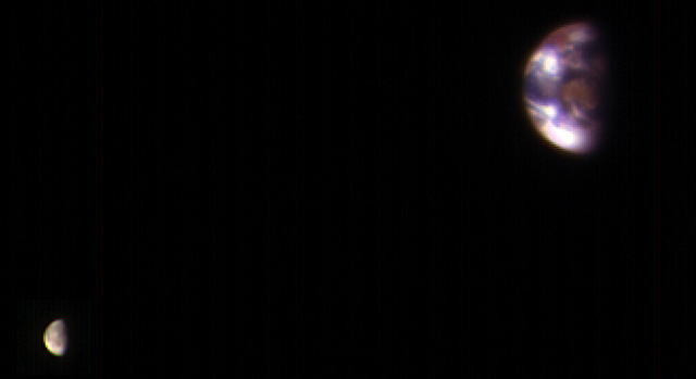 This image composite combines the best Earth image (ESP_048368_9041) with the best Moon image (ESP_048368_9044) from four sets of images acquired on 20 November 2016.
Each is separately processed prior to combining (in correct relative positions and sizes), so that the Moon is bright enough to see. The Moon is much darker than Earth and would barely show up at all if shown at the same brightness scale as Earth. Because of this brightness difference, the Earth images are saturated in the best Moon images, and the Moon is very faint in the best (unsaturated) Earth image. [More at links]
Editor note: more here describing the viewpoint and timing.