HiRISE: Soffen Crater floor

ESP_047561_1560Dr. Gerald A. Soffen (February 7, 1926 — November 22, 2000) was a project scientist for the NASA’s Viking program of Mars landers. This crater on Mars was named after him, and this image covers a small portion of the crater floor.

Here, we see a diversity of bedrock colors and textures and wind-blown (aeolian) features. [More at link]

Posted in Reports | Tagged , , , , , , , , | Comments Off

Opportunity: Soft ground

4591-navcam1F535752839EFFCUB7P1212R0M1Sol 4591, December 23, 2016. A patch of soft ground directly in front of the rover led mission controllers to roll Opportunity back downhill 0.7 meter (about 2 feet), while they assess the best route forward. Above, the view by the Navcam; at right, what the front Hazcam showed. Click either image to enlarge it.

Opportunity raw images, its latest mission status, a location map, and atmospheric opacity, known as tau.

Posted in Reports | Tagged , , , , , , | Comments Off

HiRISE: Spiders on mounds

ESP_046562_1005This terrain looks like lumpy sediment on top of patterned ground. The lumpy sediment is likely just loosely consolidated because it is covered with spidery channels.

This landform is uniquely Martian, formed in the spring as seasonal dry ice turns directly into gas that erodes channels in the surface. [More at link]

Posted in Reports | Tagged , , , , , , , | Comments Off

THEMIS: Ancient eroded craters, Meridiani Planum

Eroded craters in Meridiani Planum (THEMIS_IOTD_20151223)THEMIS Image of the Day, December 23, 2016. Today’s false color image shows eroded craters in northern Meridiani Planum.

The THEMIS VIS camera contains 5 filters. The data from different filters can be combined in multiple ways to create a false color image. These false color images may reveal subtle variations of the surface not easily identified in a single band image.

More THEMIS Images of the Day by geological topic.

Posted in Reports | Tagged , , , , , , , | Comments Off

HiRISE: Secondary craters

ESP_046876_1465This image of a southern mid-latitude crater was intended to investigate the lineated material on the crater floor. At the higher resolution of HiRISE, the image reveals a landscape peppered by small impact craters.

These craters range from about 30 meters in diameter down to the resolution limit (about 2 meter diameter in this image acquired by averaging 2×2 picture elements). Such dense clusters of small craters are frequently formed by secondary craters, caused by the impact of material that was excavated and ejected from the surface of Mars during the creation of a larger nearby crater by the impact of a comet or an asteroid. [More at link]

Posted in Reports | Tagged , , , , , , | Comments Off

Opportunity: Beacon Rock skyline

4590-pancamBRSol 4590, December 22, 2016. In the last two sols, Opportunity drove a short distance (6.4 meters, 21 feet) up the slope. From there, the Pancam took a westward-facing profile of Beacon Rock on the skyline (above). From this lower viewpoint, the summit appears to consist mostly of small and mid-size rocks, all close together. Perhaps the wind blowing over the ridge from the east has removed much of the sand and dust “soil” around them.

Below, the Navcam shot four frames centered on northeast. A close look at the right two frames in the enlarged composite shows the rover tracks heading upslope to this point. (Click either image to enlarge.)

Opportunity raw images, its latest mission status, a location map, and atmospheric opacity, known as tau.

4590-navcam

Posted in Reports | Tagged , , , , , , , | Comments Off

Curiosity update: Preparing for the holidays

1553ML0079770040604750E01_DXXX
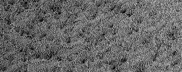
Sol 1566-68, December 21, 2016, update by USGS scientist Lauren Edgar: Today was our last tactical planning day before the team takes a break over the holidays.  But that doesn’t mean that Curiosity will be resting!  A group of science team members and operations staff assembled an 8-sol plan that will execute over December 22-30, focused on environmental monitoring and change detection.  Today’s tactical planning was aimed at creating a 3-sol plan that will take place over New Year’s, from December 31-January 2.  When we return to normal operations on January 3, we’ll dive right back in to a campaign investigating some interesting fracture patterns at “Old Soaker,” seen in the Mastcam image above.

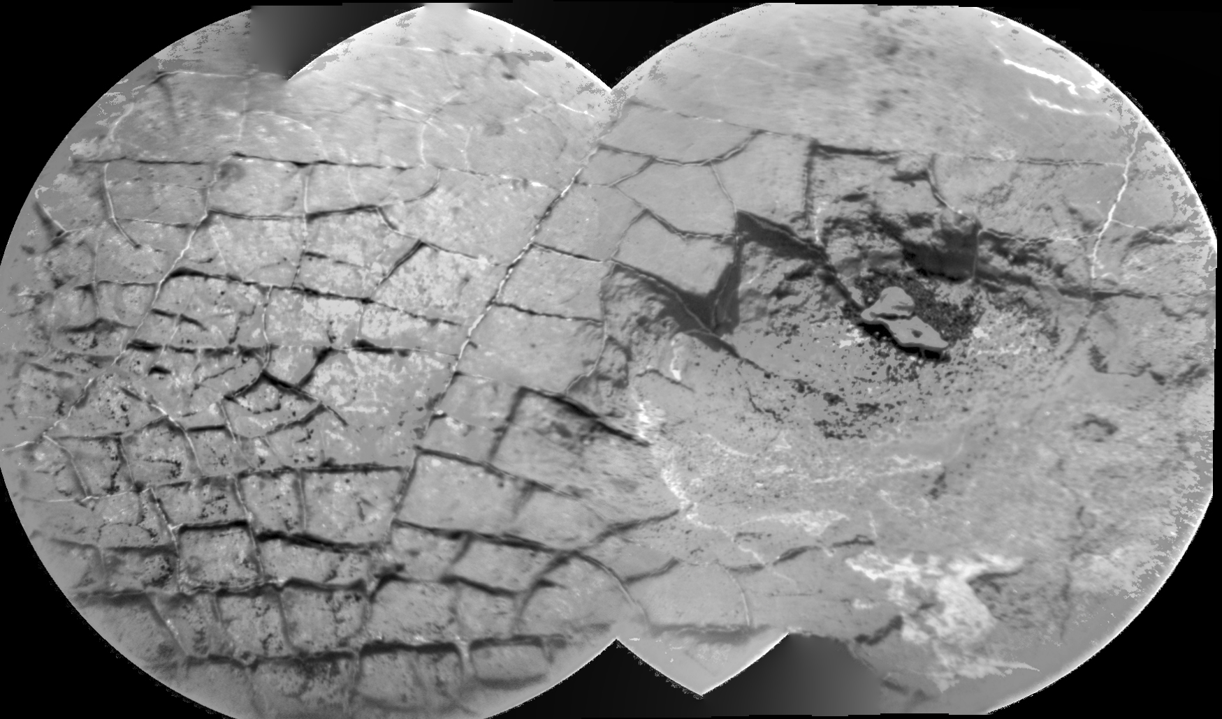
Today’s 3-sol plan starts with Mastcam multispectral observations of the targets “Old Soaker” and “Schooner Head” to assess their red and gray color variations.  This is followed by a Navcam observation to search for dust devils.  Then ChemCam will target “Moore Harbor” and “Northeast Harbor” to look for variations in chemistry.  (…)

This will be the last [Curiosity update] blog [post] until January 3 when we resume normal operations.  Until then – may your sols be merry and bright, and safe travels as you rove into the New Year! [More at link]
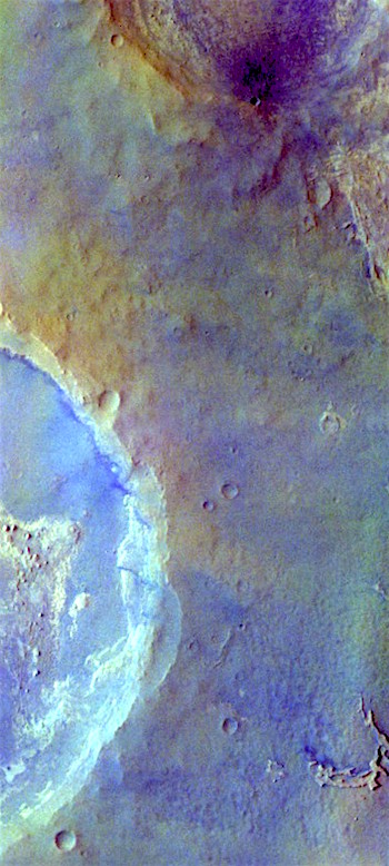
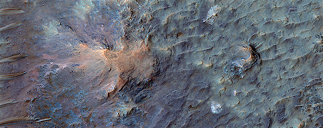
Posted in Reports | Tagged , , , , , , , , , , , , , , , , , , | Comments Off

HiRISE: Lace on Mars

ESP_046414_0990Some seasonal ice on Mars is transparent so that the sunlight penetrates to the bottom of the ice. Heat from this sunlight can turn the ice directly into a gas in a process called sublimation and this gas can scour channels in the loose dirt under the ice.

Channels formed by sublimation of a layer of seasonal dry ice are so dense in this area that they look like lace. Gas flow erodes channels as it escapes to the surface of the overlying seasonal ice layer seeking the path of least resistance. [More at link]

Posted in Reports | Tagged , , , , , , , | Comments Off

THEMIS: Peace Vallis alluvial fan in Gale Crater

Peace Vallis fan in Gale Crater (THEMIS_IOTD_20161222)THEMIS Image of the Day, December 22, 2016. Today’s false color image shows part of Gale Crater. Gale Crater is the home of the Curiosity Rover. The channel descending from the rim rocks at top is called Peace Vallis, and a stream once flowed through the channel. The stream washed sand and gravel down onto the floor of Gale Crater, making a large, smooth area — which scientists call an alluvial fan — in the center of this image. Curiosity landed on part of the fan.

The THEMIS VIS camera contains 5 filters. The data from different filters can be combined in multiple ways to create a false color image. These false color images may reveal subtle variations of the surface not easily identified in a single band image.

More THEMIS Images of the Day by geological topic.

Posted in Reports | Tagged , , , , , , , , , , , | Comments Off

Curiosity: Cracked rock

1555-rmiSol 1555, December 20, 2016. The Remote Micro-Imager  took aim at a rock target showing a tile-like pattern of cracks that appear to be partly filled with minerals, likely deposited by water. The right side of the four-frame composite shows a hollowed-out area, possibly due to differential erosion. Click image to enlarge.

Sol 1555 raw images (from all cameras), and Curiosity’s latest location.

Posted in Reports | Tagged , , , , , , , , , , , | Comments Off