Opportunity: Driving up the hill

4587-navcamSol 4587, December 19, 2016. The rover’s Navcam took the composite image above following a 31-meter (102-foot) drive uphill the day before (note Opportunity’s wheel tracks). The view (3.1 MB) looks generally east.

Also on Sol 4587, the Pancam shot a five-frame profile (2.7 MB, below) of a feature on the south-southeast skyline dubbed Mount Jefferson, after a volcano noted and named by the Lewis & Clark expedition. (False color reconstructions by Holger Isenberg.) Both images enlarge when clicked.

Opportunity raw images, its latest mission status, a location map, and atmospheric opacity, known as tau.4587-pancamFC

Posted in Reports | Tagged , , , , , , , | Comments Off

HiRISE: Bedrock on crater floor

tumblr_oi8xkgJrtQ1rlz4gso1_1280Bedrock on crater floor. Beautiful Mars series.

Posted in Reports | Tagged , , , , , , , | Comments Off

THEMIS: Part of Gale Crater in false color

Northeast Gale Crater in false color (THEMIS_IOTD_20161219)THEMIS Image of the Day, December 19, 2016. Today’s false color image shows part of Gale Crater. The Curiosity Rover is located off this image to the west. The blue areas are probably covered with basaltic sand.

The THEMIS VIS camera contains 5 filters. The data from different filters can be combined in multiple ways to create a false color image. These false color images may reveal subtle variations of the surface not easily identified in a single band image.

More THEMIS Images of the Day by geological topic.

Posted in Reports | Tagged , , , , , , , , , | Comments Off

Curiosity update: Diagnostics, science, and a drive

1550MR0079500010800073E01_DXXX-br2Sol 1552-54, December 16, 2016, update by USGS scientist Ryan Anderson: The engineering team is still hard at work diagnosing our drill issues, but in the meantime we are still getting good science done. The Sol 1552 plan starts off with ChemCam observations of the targets “Hall Quarry” and “Long Porcupine”. Mastcam will document those targets and then do a multispectral observation of “Western Head”. Mastcam also has an image of the rover deck, and Navcam will watch for dust devils. There will also be some drill diagnostics on Sol 1552. [More at link]

Posted in Reports | Tagged , , , , , , , , , , , | Comments Off

HiRISE: Hematite-rich deposits in Capri Chasma

ESP_047792_1670Capri Chasma is located in the eastern portion of the Valles Marineris canyon system, the largest known canyon system in the Solar System. Deeply incised canyons such as this are excellent targets for studying the Martian crust, as the walls may reveal many distinct types of bedrock.

This section of the canyon was targeted by HiRISE based on a previous spectral detection of hematite-rich deposits in the area. Hematite, a common iron-oxide mineral, was first identified here by the Mars Global Surveyor Thermal Emission Spectrometer (TES). In this TES image, red pixels indicate higher abundances of hematite, while the blue and green pixels represent different types of volcanic rocks (e.g., basalt). [More at link]

Posted in Reports | Tagged , , , , , , , , | Comments Off

ExoMars 2016: Skimming an alien atmosphere

After the smooth arrival of ESA’s latest Mars orbiter, mission controllers are now preparing it for the ultimate challenge: dipping into the Red Planet’s atmosphere to reach its final orbit.

The ExoMars Trace Gas Orbiter is on a multiyear mission to understand the tiny amounts of methane and other gases in Mars’ atmosphere that could be evidence for possible biological or geological activity.

Following its long journey from Earth, the orbiter fired its main engine on 19 October to brake sufficiently for capture by the planet’s gravity.

It entered a highly elliptical orbit where its altitude varies between about 250 km and 98 000 km, with each circuit taking about four Earth days.

Ultimately, however, the science goals and its role as a data relay for surface rovers mean the craft must lower itself into a near-circular orbit at just 400 km altitude, with each orbit taking about two hours. [More at link]

Posted in Reports | Tagged , , , , , , , | Comments Off

Full go-ahead for building ExoMars 2020

Exomars PHASE B1 8.05.2008
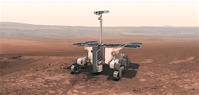
The first ExoMars mission arrived at the Red Planet in October and now the second mission has been confirmed to complete its construction for a 2020 launch. ESA and Thales Alenia Space signed a contract today [Dec 16, 2016] that secures the completion of the European elements of the next mission.

The main objective of the ExoMars programme is to address one of the most outstanding scientific questions of our time: is there, or has there ever been, life on Mars?

The Trace Gas Orbiter will soon be exploring this question from orbit: it will take a detailed inventory of trace gases, such as methane, that might be linked to biological or geological processes. The first test of the orbiter’s science instruments was recently completed. It will also act as a communications relay for various craft – in particular for 2020′s rover and surface platform.

ESA’s rover will be the first capable of drilling 2 m into Mars, where ancient biomarkers may still be preserved from the harsh radiation environment on the surface. The Russian platform will carry instruments focused on the local atmosphere and surroundings.

ExoMars is a joint endeavour between ESA and Roscosmos, with important contribution from NASA. [More at link]
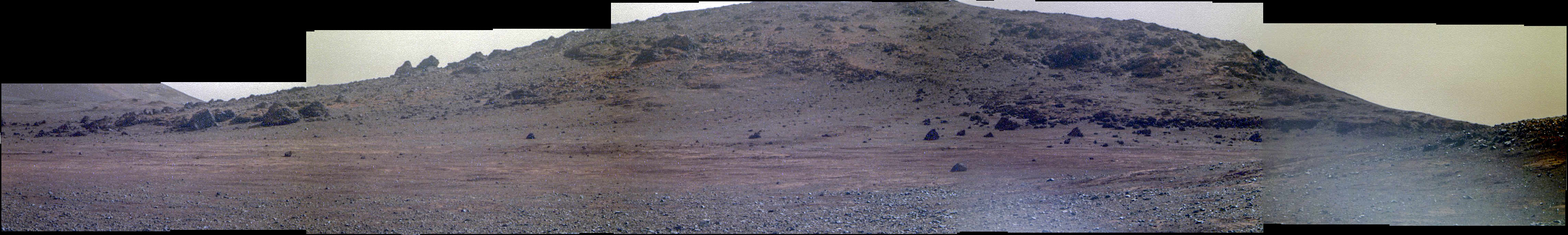
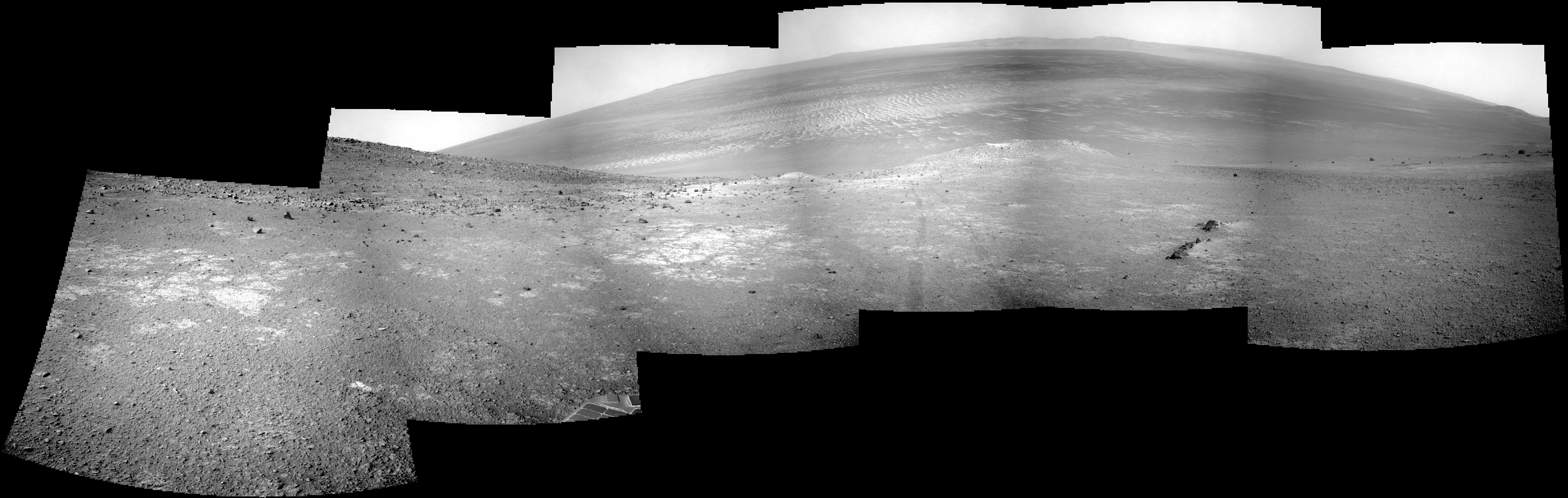
Posted in Reports | Tagged , , , , , , , | Comments Off

HiRISE: Slope streaks or recurring slope lineae?

ESP_047584_2115The image shows a region we see many slope streaks, typically dark features on slopes in the equatorial regions on Mars. They may extend for tens of meters in length and gradually fade away with time as new ones form. The most common hypothesis is that they are generated by dust avalanches that regularly occur on steep slopes exposing fresh dark materials from underneath the brighter dust.

There are many types of slope streaks but one of the most recent and significant findings using HiRISE was the discovery of a new type called “recurring slope lineae,” or RSL for short. Recent studies suggest that RSL may form through the flow of briny (extremely salty) liquid water that can be stable on the surface of Mars even under current climatic conditions for a limited time in summer when it is relatively warm. [More at link]

Posted in Reports | Tagged , , , , , , , , | Comments Off

THEMIS: Hale Crater’s rugged central peaks

Rugged peaks in Hale Crater (THEMIS_IOTD_20161216)THEMIS Image of the Day, December 16, 2016. This VIS image shows part of the floor of Hale Crater. The mountains in the image are part of the elongated central peak of the crater. It is believed that Hale Crater was formed by an oblique impact, which caused its more oval form and central peak elongation.

More THEMIS Images of the Day by geological topic.

Posted in Reports | Tagged , , , , , , , , , | Comments Off

Curiosity: Oak Hill butte

1548MR0079480000800070E01_DXXXSol 1548, December 13, 2016. With Curiosity parked at Precipice while the drill undergoes more diagnosis and testing, the Mastcam, using its 100mm telephoto lens, snapped a picture of a small butte named Oak Hill. This feature lies about 1 kilometer (0.6 mile) due east from the rover’s position. (The butte dubbed Ireson Hill lies to the south of the rover.)

Sol 1548 raw images (from all cameras), and Curiosity’s latest location.

Posted in Reports | Tagged , , , , , , , , , , | Comments Off