Opportunity: Onward and upward

4577-navcam
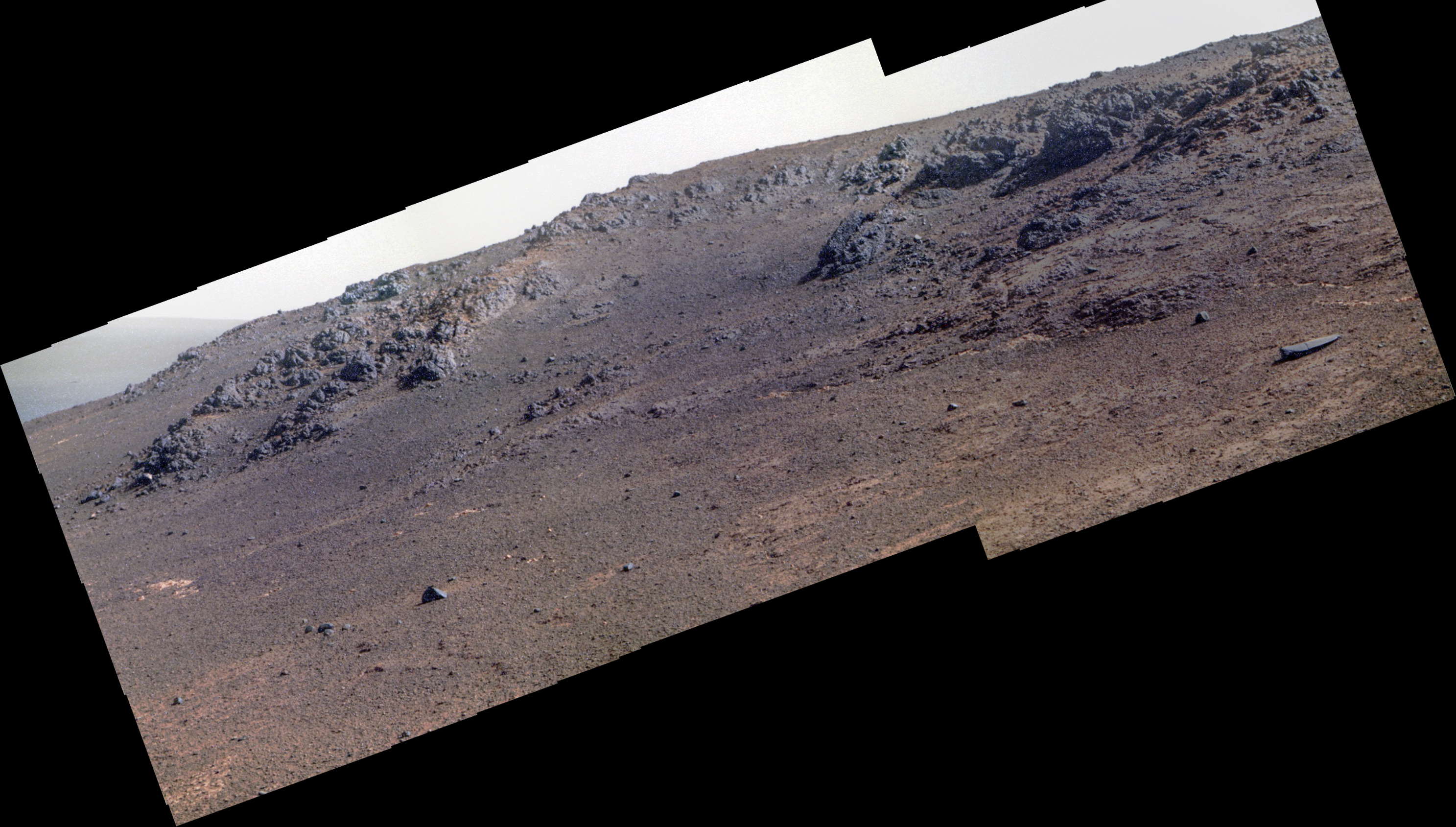
Sol 4577, December 9, 2016. On this sol, Opportunity drove 11.5 meters (38 feet) uphill toward the south, as it climbs to get around the ridge at left. The box in the Navcam composite above locates approximately the two-frame Pancam snapshot, below, aimed in the direction the rover is driving. Click either image to enlarge it.

Opportunity raw images, its latest mission status, a location map, and atmospheric opacity, known as tau.

4577-pancam-drive

Posted in Reports | Tagged , , , , , , , | Comments Off

THEMIS: Gullies in Noachis crater rim

Noachis crater gullies (THEMIS_IOTYD_20161209)THEMIS Image of the Day, December 9, 2016. Numerous large gullies dissect the inner rim of this unnamed crater in Noachis Terra. (If the gullies looks like ridges, remember that the lighting is coming from the right side of the image.)

More THEMIS Images of the Day by geological topic.

Posted in Reports | Tagged , , , , , , , , | Comments Off

Curiosity update: Diagnostics & remote sensing

1542MR0079170000800046E01_DXXXSol 1544, December 8, 2016, update by USGS scientist Lauren Edgar: The plan for Sol 1544 includes remote sensing and additional diagnostics to resolve the drill feed fault.  The plan starts with a Mastcam tau and crater rim extinction observation to monitor dust in the atmosphere.  Then we’ll acquire ChemCam observations of “Aunt Betty Pond” and “Kebo Mountain” to assess the composition of the Murray bedrock and veins.  In the afternoon we’ll repeat the Mastcam tau and crater rim extinction observations.  We’ll also take a few more rear Hazcam images to monitor the movement of fines at different… [More at link]

Posted in Reports | Tagged , , , , , , , , , , | Comments Off

HiRISE: Cracks in a crater’s ice

ESP_047247_1150Many impact craters on Mars were filled with ice in past climates. Sometimes this ice flows or slumps down the crater walls into the center and acquires concentric wrinkles as a result. This image shows an example of this.

There are other ways that scientists know the material in the crater is icy. Surface cracks that form polygonal shapes cover the material in the crater. They are easy to see in this spring-time image because seasonal frost hides inside the cracks, outlining them in bright white. These cracks form because ice within the ground expands and contracts a lot as it warms and cools. [More at link]

Posted in Reports | Tagged , , , , , , | Comments Off

MARCI weather report, Nov 28-Dec 4, 2016

Screen Shot 2016-12-09 at 1.35.00 PMMartian dust-lifting activity continued to be uneventful this past week as spring and fall transitioned to southern hemisphere summer and northern hemisphere winter. Dust hazes persisted over the southern high latitudes for most of the week. The area known as the Mountains of Mitchel still displayed small amounts of CO2 ground frost; though as summer continues to take hold these slopes will soon be frost-free. [More at link, including video]

Posted in Reports | Tagged , , , , , , , , , , , , , | Comments Off

Opportunity: Pancam views Blackbird Hill

4576-pancamSol 4576, December 7, 2016. Blackbird Hill is the name applied to this portion of Southwest Ridge. Easy to see why rover drivers would prefer to go upslope to get around the ridge. (False-color restorations by Holger Isenberg.) Click image (2.5 MB) to enlarge it.

Opportunity raw images, its latest mission status, a location map, and atmospheric opacity, known as tau.

Posted in Reports | Tagged , , , , , , , , | Comments Off

HiRISE: Coolest landscape on Mars or Earth

ESP_047304_0930Many Martian landscapes contain features that are familiar to ones we find on Earth, like river valleys, cliffs, glaciers and volcanos.

However, Mars has an exotic side too, with landscapes that are alien to Earthlings. This image shows one of these exotic locales at the South Pole. The polar cap is made from carbon dioxide (dry ice), which does not occur naturally on the Earth. The circular pits are holes in this dry ice layer that expand by a few meters each Martian year. [More at link]

Posted in Reports | Tagged , , , , , , , | Comments Off

THEMIS: ‘Channels’ in Icaria Fossae

Icaria Fossae (THEMIS_IOTD_20161208)THEMIS Image of the Day, December 8, 2016. The channel-like features in this VIS image are tectonic graben. The graben (called Icaria Fossae) are located in Terra Sirenum. The graben are caused by tectonic forces that faulted the bedrock, allowing linear sections of surface to drop downward, making the graben.

More THEMIS Images of the Day by geological topic.

Posted in Reports | Tagged , , , , , , , , , , | Comments Off

HiRISE: Painting with frost

ESP_047074_1030Subtle variations in color look like brush strokes as the lightly frosted terrain reflects light. These variations provide a backdrop to some exotic features referred to colloquially as “spiders.”

The radial channels branching out from a central depression are formed when the seasonal layer of dry ice turns to gas in the spring and erodes the surface, which is a uniquely Martian landform. [More at link]

Posted in Reports | Tagged , , , , , , , | Comments Off

Curiosity update: Motor controller fault

CR0_533230219EDR_F0592830CCAM03528M_Sol 1543, December 7, 2016, update by USGS scientist Ken Herkenhoff: The Sol 1542 drill diagnostics did not complete as intended, and as a consequence, neither did some of the later science activities.  Therefore, those tests and activities from Sol 1542 will be planned again on Sol 1543.  But first, ChemCam will shoot its laser at a target near Hunters Beach, called “Bracy Cove,” and at the bright layers just above The Anvil.  Late in the afternoon, ChemCam will perform a routine observation of its titanium calibration target, the Left Mastcam will acquire a 5×1 mosaic of “Squid Cove,” and the Rear Hazcam will take another… [More at link]

Posted in Reports | Tagged , , , , , , , , , , , , | Comments Off