HiRISE: Gully on Hecates Tholus

tumblr_ohq3dfL4261rlz4gso1_1280Gully on Hecates Tholus. Beautiful Mars series.

Posted in Reports | Tagged , , , , , , , , , | Comments Off

Curiosity: RMI studies Sargent Mountain

1542-rmiSol 1542, December 6, 2016. Curiosity is parked while engineers figure out why the drill feed mechanism stopped advancing the drill before it touched the rock. Meanwhile, the Remote Micro-Imager (RMI) shoots a four-frame sequence across a target dubbed Sargent Mountain. Clikc image to enlarge it.

Sol 1542 raw images (from all cameras), and Curiosity’s latest location.

Posted in Reports | Tagged , , , , , , , , , | Comments Off

THEMIS: Crater on crater in Noachis Terra

Crater on crater in Noachis Terra (THEMIS_IOTD_20161207)THEMIS Image of the Day, December 7, 2016. This VIS images shows part of two unnamed craters in Noachis Terra. The younger of the two craters is at the bottom of the image with one side visible in the image. The older and much larger crater has just part of the rim and floor visible towards the top of the image. The overlapping of one crater on top of another allows for relative dating to be done. We don’t know the exact ages of each crater, but we can define which came first.

More THEMIS Images of the Day by geological topic.

Posted in Reports | Tagged , , , , , , , , , | Comments Off

Curiosity update: More drill testing

CR0_534288894PRC_F0592830CCAM01541L1Sol 1542, December 6, 2016, update by USGS scientist Ken Herkenhoff: While investigation of the drill anomaly continues, more diagnostic tests will be performed on Sol 1542.  Again, no mobility or other arm activities will be planned, so the science team added only remote sensing observations.  ChemCam will observe Hunters Beach [right] again to further investigate the the chemical variations that LIBS measured there previously. [More at link]

Posted in Reports | Tagged , , , , , , , , , , , | Comments Off

Opportunity: Southwest Ridge in false color

4571-pancamSol 4571, December 2, 2016. The Pancam shot a sequence of filtered frames looking toward the southeast. The second-left filtered frame was sent back to Earth missing one filtered image and another is incomplete, hence its odd coloration and appearance. (False-color reconstructions by Holger Isenberg.)

The outcrops at the right edge of the composite image belong to a feature dubbed Southwest Ridge. Given the steep slopes to the left, rover drivers plan to steer Opportunity around the ridge on its uphill side toward the right. Click the image (3.2 MB) to enlarge it.

Opportunity raw images, its latest mission status, a location map, and atmospheric opacity, known as tau.

Posted in Reports | Tagged , , , , , , , | Comments Off

HiRISE: Periglacial terrain & dust devil tracks

tumblr_ohq31mdWWi1rlz4gso1_1280Periglacial terrain. Beautiful Mars series.

Posted in Reports | Tagged , , , , , , , , , | Comments Off

Curiosity team studies new drill hiatus

pia21140-16
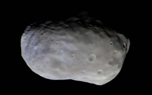
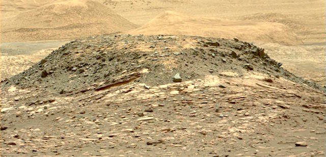
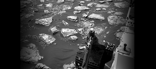
NASA’s Curiosity Mars rover is studying its surroundings and monitoring the environment, rather than driving or using its arm for science, while the rover team diagnoses an issue with a motor that moves the rover’s drill.

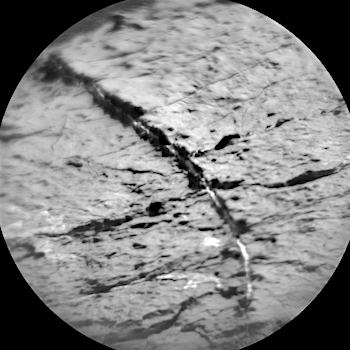
Curiosity is at a site on lower Mount Sharp selected for what would be the mission’s seventh sample-collection drilling of 2016. The rover team learned Dec. 1 that Curiosity did not complete the commands for drilling. The rover detected a fault in an early step in which the “drill feed” mechanism did not extend the drill to touch the rock target with the bit.

“We are in the process of defining a set of diagnostic tests to carefully assess the drill feed mechanism. We are using our test rover here on Earth to try out these tests before we run them on Mars,” Curiosity Deputy Project Manager Steven Lee, at NASA’s Jet Propulsion Laboratory in Pasadena, California, said Monday. “To be cautious, until we run the tests on Curiosity, we want to restrict any dynamic changes that could affect the diagnosis. That means not moving the arm and not driving, which could shake it.”

Two among the set of possible causes being assessed are that a brake on the drill feed mechanism did not disengage fully or that an electronic encoder for the mechanism’s motor did not function as expected. Lee said that workarounds may exist for both of those scenarios, but the first step is to identify why the motor did not operate properly last week. [More at link]

Posted in Reports | Tagged , , | Comments Off

ExoMars: Trace Gas Orbiter images Phobos

ESA_TGO_CaSSIS_Phobos_PAN_NRB_20161126_1280The ExoMars Trace Gas Orbiter has imaged the martian moon Phobos as part of a second set of test science measurements made since it arrived at the Red Planet on 19 October.

The Trace Gas Orbiter (TGO), a joint endeavour between ESA and Roscosmos, made its first scientific calibration measurements during two orbits between 20 and 28 November.

Example data from the first orbit were published last week, focusing on Mars itself. During the second orbit, the instruments made a number of measurements of Phobos, a 27×22×18 km moon that orbits Mars at a distance of only 6000 km.

The camera imaged the moon on 26 November from a distance of 7700 km, during the closest part of the spacecraft’s orbit around Mars. TGO’s elliptical orbit currently takes it to within 230–310 km of the surface at its closest point and around 98 000 km at its furthest every 4.2 days.

A colour composite has been created from several individual images taken through several filters. The camera’s filters are optimised to reveal differences in mineralogical composition, seen as ‘bluer’ or ‘redder’ colours in the processed image. [More at link, including a red/blue anaglyph]

Posted in Reports | Tagged , , , , , , , , , | Comments Off

Curiosity update: Change detection

1539MR0079090000800035E01_DXXXSol 1541, December 5, 2016, update by USGS scientist Lauren Edgar: The weekend plan returned some great remote sensing data, including the above Mastcam image of “Ireson Hill” to investigate the stratigraphy exposed in a distant butte. While we work on assessing the drill fault, the team decided to devote today’s plan to remote sensing and change detection.  The plan starts with ChemCam observations of “Hunters Beach” and “Gorham Mountain” to investigate the chemistry of the Murray bedrock.  Then we’ll acquire a Mastcam tau and crater rim extinction image to characterize the amount of dust in the… [More at link]

Posted in Reports | Tagged , , , , , , , , , , , | Comments Off

THEMIS: Dune field in Rabe Crater

Dune field in Rabe Crater (THEMIS_IOTD_20161206)THEMIS Image of the Day, December 6, 2016. Today’s VIS image shows a small part of the dune field on the floor of Rabe Crater.

More THEMIS Images of the Day by geological topic.

Posted in Reports | Tagged , , , , , , , , , | Comments Off