HiRISE: A glimpse into history

ESP_046851_2040Nothing gets a geologist more excited than layered bedrock, except perhaps finding a fossil or holding a meteorite in your hand. All of these things create a profound feeling of history, the sense of a story that took place ages ago, long before we came appeared. Layered bedrock in particular tells a story that was set out chapter by chapter as each new layer was deposited on top of older, previously deposited layers.

Here in Nili Fossae, we see layered bedrock as horizontal striations in the light toned sediments in the floor of a canyon near Syrtis Major. Note… [More at link]

Posted in Reports | Tagged , , , , , , , , , , | Comments Off

Curiosity: Forward vista

1516-navcamSol 1516, November 10, 2016. Shifting the rover’s focus from the closeup on Southwest Harbor’s details, Curiosity’s Navcam takes in the vista lying before the rover. Note that the surface materials here have become roughly half and half sand and rock, a contrast with previous weeks where the driving has been mainly across rocks. Click image (2MB) to enlarge it.

Sol 1516 raw images (from all cameras), and Curiosity’s latest location.

Posted in Reports | Tagged , , , , , , , , | Comments Off

Beagle 2 landed intact and deployed most or all of its solar panels, says new study

beagle2-simScientists in Leicester [UK] have moved one step closer to understanding exactly what happened to the ill-fated Mars Lander Beagle 2, thanks to an innovative research technique. The probe was discovered on the Red Planet in November 2014 but uncertainty surrounded what had caused its failure to communicate with Earth.

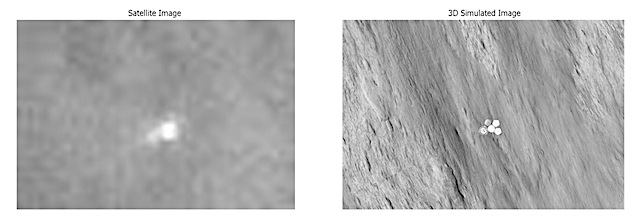
Now, a collaboration between De Montfort University and the University of Leicester, has used 3D modelling technology to reveal for the first time that Beagle 2 deployed at least three, and possibly all four, of the solar panels it was supposed to after touching down on the planet’s surface. (…)

Beagle 2 was part of the ESA Mars Express Mission launched in June 2003. Mars Express is still orbiting Mars and returning scientific data on the planet. Beagle 2 was successfully ejected from ESA’s Mars Express spacecraft on 19 December 2003 but failed to send a signal on Christmas Day – its scheduled landing day on Mars. It was presumed lost until over a decade later when the mystery of what happened to the mission was solved through images taken by NASA’s Mars Reconnaissance Orbiter (MRO).

Despite its detection, due to the small size of the lander and the resolution of the HiRISE camera on the MRO, the exact configuration of the lander on Mars was not clear – despite collection of 8 images of the lander and use of advanced image processing techniques.

Now the researchers from De Montfort University and the University of Leicester have worked together to come up with a new way to detect the configuration of the lander. [More at link]
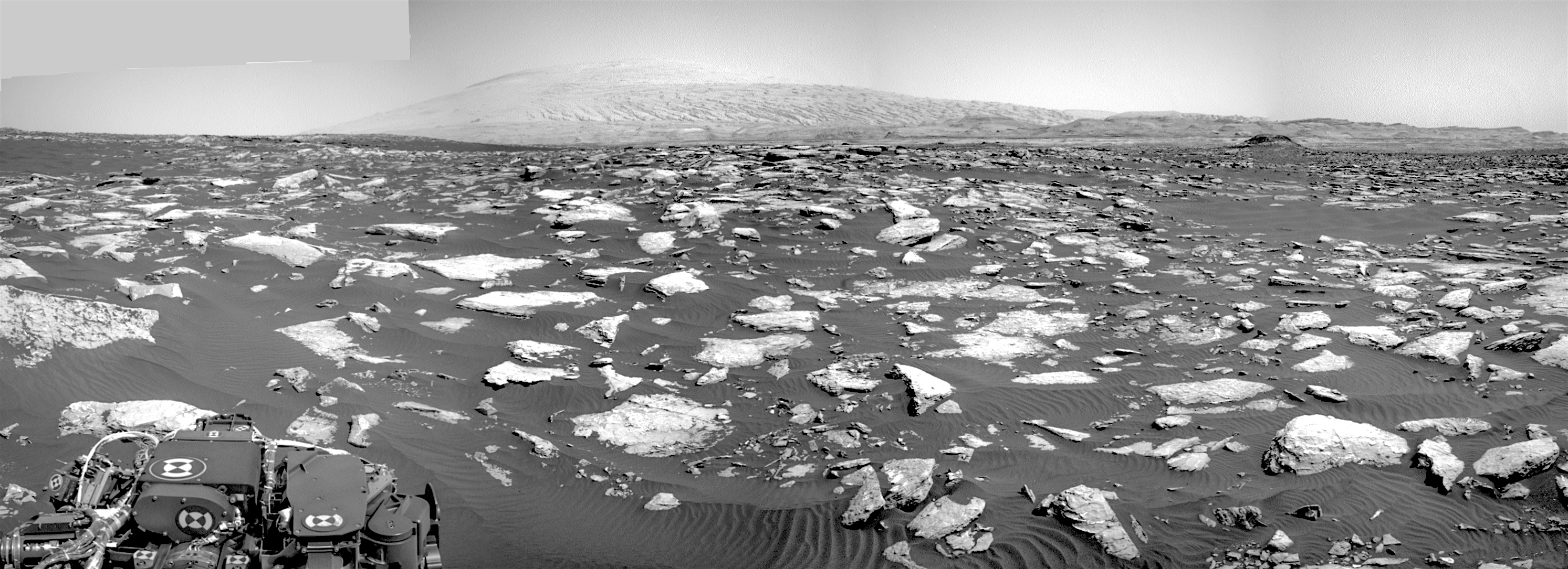
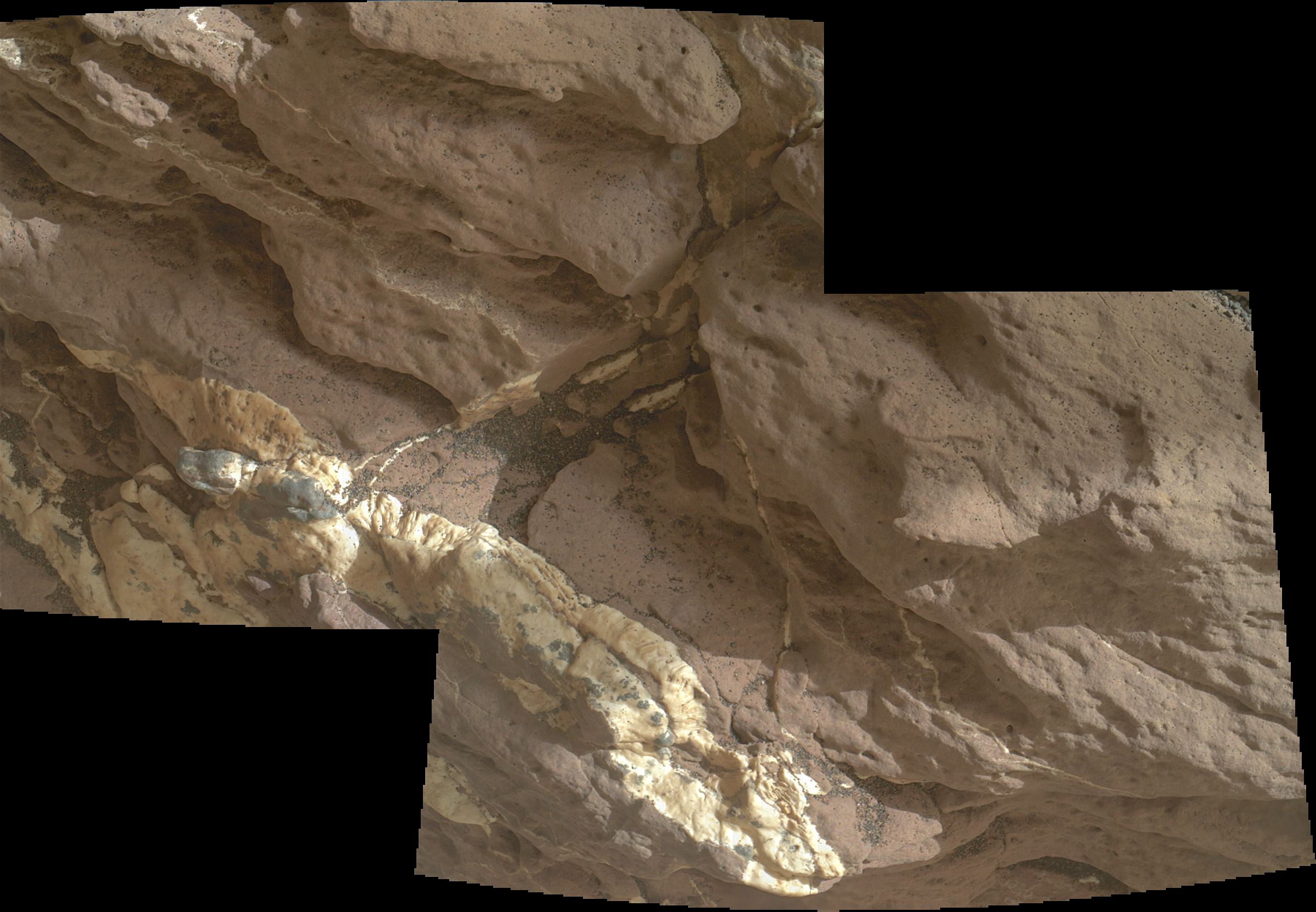
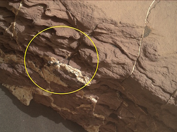
Posted in Reports | Tagged , , , , , , , , | Comments Off

Opportunity near Pompy’s Tower

4550-navcamSol 4550, November 11, 2016. Continuing its journey along Endeavour Crater’s rim, Opportunity stands near Pompy’s Tower (left) in the Navcam composite above. The yellow rectangle indicates the area shown below in the two Pancam frames that take a look at surface rocks nearby. Like many rocks found on the rim, they have a “faceted” appearance suggesting they have been abraded, smoothed, and shaped by wind-blown dust particles. (Click either image to enlarge it.)

Opportunity raw images, its latest mission status, a location map. and atmospheric opacity, known as tau.

4550-pancam

Posted in Reports | Tagged , , , , , , , , | Comments Off

HiRISE: Exposed fractured bedrock in a crater

ESP_046777_1680This HiRISE image shows the central pit feature of an approximately 20-kilometer diameter complex crater in located at 304.480 degrees east, -11.860 degrees south, just north of the Valles Marineris. Here we can observe a partial ring of light-toned, massive and fractured bedrock, which has been exposed by the impact-forming event, and via subsequent erosion that typically obscure the bedrock of complex central features. Features such as this one are of particular interest as they provide… [More at link]

Posted in Reports | Tagged , , , , , , , , , | Comments Off

THEMIS: Varied geology in Schiaparelli Crater

Varied geology in Schiaparelli Crater (THEMIS_IOTD_20161111)THEMIS Image of the Day, November 11, 2016. Today’s false color image shows part of the floor of Schiaparelli Crater. The THEMIS VIS camera contains 5 filters. The data from different filters can be combined in multiple ways to create a false color image. These false color images may reveal subtle variations of the surface not easily identified in a single band image.

More THEMIS Images of the Day by geological topic.

Posted in Reports | Tagged , , , , , , | Comments Off

HiRISE: Rafted rock

ESP_046530_2020This area of Amazonis Planitia to the west of the large volcano Olympus Mons was once flooded with lava. A huge eruption flowed out across the relatively flat landscape. Sometimes called “flood basalt,” the lava surface quickly cooled and formed a thin crust of solidified rock that was pushed along with the flowing hot liquid rock. Hills and mounds that pre-dated the flooding… [More at link]

Posted in Reports | Tagged , , , , , , , , , | Comments Off

Curiosity: Southwest Harbor

1514-mahli21514MH0001900010600074C00_DXXXSol 1514, November 9, 2016. The MAHLI surveys the target dubbed Southwest Harbor. At right, a general view with the circle showing the area in close-up above. (Click close-up to enlarge it; 2.4 MB.)

Sol 1514 raw images (from all cameras), and Curiosity’s latest location.

Posted in Reports | Tagged , , , , , , , , , | Comments Off

HiRISE: Trundling boulders

ESP_046381_1665This picture of the rim of Eos Chasma in Valles Marineris shows active erosion of the Martian surface. Layered bedrock is exposed in a steep cliff on a spur of the canyon rim. Dark layers in this cliff are made up of large boulders up to 4 meters in diameter. The boulders are lined up along specific horizons, presumably individual lava flows, and are perched to descend down into the canyon upon the slightest disturbance. How long will the boulders remain poised to fall, and what will push them over the edge? [More at link]

Posted in Reports | Tagged , , , , , , , , , | Comments Off

THEMIS: Mesa’s edge in Chryse Planitia

Chryse Planitia mesa (THEMIS_IOTD_20161110)THEMIS Image of the Day, November 10, 2016. Today’s false color image shows part of the margin of Chryse Planitia. Dark blue in this false color combination is mostly likely basaltic material/dunes.

The THEMIS VIS camera contains 5 filters. The data from different filters can be combined in multiple ways to create a false color image. These false color images may reveal subtle variations of the surface not easily identified in a single band image.

More THEMIS Images of the Day by geological topic.

Posted in Reports | Tagged , , , , , , , , , | Comments Off