HiRISE: Mesa in Amazonis Planitia

tumblr_of85i9VcZ51rlz4gso2_1280A mesa in Amazonis Planitia. Beautiful Mars series.

Posted in Reports | Tagged , , , , , , , , , | Comments Off

Curiosity update: A very busy weekend

1496MH0001900010504609C00_DXXX-br2Sol 1497-99, October 21, 2016, update by USGS scientist Ryan Anderson: We’ve got quite a plan in store for the weekend, with every single instrument doing something, multiple arm activities, and a drive. Curiosity’s battery will be run all the way down to 35% which is quite rare, but necessary when there’s a lot to do!

Sol 1497 starts off with ChemCam observations of the targets “Okambonde” and “Nokaneng” and supporting Mastcam images. Next we lift APXS off of the tailings pile it had been analyzing and take some MAHLI images of the print that it left. MAHLI also will take… [More at link]

Posted in Reports | Tagged , , , , , , , , , , , , , , | Comments Off

Curiosity update: Successful drill!

FRB_530208778EDR_F0582046FHAZ00202M_-br2Sol 1496, October 21, 2016, update by USGS scientist Ken Herkenhoff: Yesterday’s plan went well and we have a new drill hole on Mars! The plan for Sol 1496 starts with a ChemCam passive observation of the dump pile of material from “Quela”, our previous drill hole. ChemCam also has passive observations of the tailings from the new hole at “Sebina”, followed by active observations using the laser. Mastcam then has some observations of the tailings and dump pile, plus an image to monitor the sand and dust on the rover deck, and a couple of atmospheric observations. Also in the 1496 plan…. [More at link]

Posted in Reports | Tagged , , , , , , , , , , | Comments Off

HiRISE: Wrinkle ridges and pit craters

ESP_046817_1775Tectonic stresses highly modified this area of Ganges Catena, north of Valles Marineris. The long, skinny ridges (called “wrinkle ridges”) are evidence of compressional stresses in Mars’ crust that created a crack (fault) where one side was pushed on top of the other side, also known as a thrust fault.

As shown by cross-cutting relationships, however, extensional stresses have more recently pulled the crust of Mars apart in this region. (HiRISE imaged this area in 2-by-2 binning mode, so a pixel represents a 50 x 50 square centimeter.) [More at link]

Posted in Reports | Tagged , , , , , , , , , , | Comments Off

Curiosity: Drill hole at Sebina

NLB_530302852EDR_F0582046NCAM00368M_1496MH0001900010504609C00_DXXXSol 1496, October 21, 2016. Curiosity did its full drill on the target named Sebina, as seen in the cropped Navcam frame above and in the MAHLI shot at right. Note the nodules shown in the MAHLI frame. (Both images enlarge when clicked.)

As noted, winds are active here. The drill tailings blew off to the right of the hole. And in the Navcam frame, dark sand between the rock slabs shows ripples indicating winds are moving loose material at surface level.

Sol 1496 raw images (from all cameras), and Curiosity’s latest location.

Posted in Reports | Tagged , , , , , , , , , , | Comments Off

THEMIS: Varied deposit in Firsoff Crater

Firsoff Crater deposit (THEMIS_IOTD_20161021)THEMIS Image of the Day, October 21, 2016.  Today’s false color image shows part of the interior deposit of Firsoff Crater. (This image lies just west of the one from October 13 and partly overlaps it.)  The dark blue material is most likely basaltic sand. The THEMIS VIS camera contains 5 filters. The data from different filters can be combined in multiple ways to create a false color image. These false color images may reveal subtle variations of the surface not easily identified in a single band image.

More THEMIS Images of the Day by geological topic.

Posted in Reports | Tagged , , , , , , , , | Comments Off

MRO spots Schiaparelli impact scar, parachute

PIA21130NASA’s Mars Reconnaissance Orbiter has identified new markings on the surface of the Red Planet that are believed to be related to ESA’s ExoMars Schiaparelli entry, descent and landing technology demonstrator module.

Schiaparelli entered the martian atmosphere at 14:42 GMT on 19 October for its 6-minute descent to the surface, but contact was lost shortly before expected touchdown. Data recorded by its mothership, the Trace Gas Orbiter, are currently being analysed to understand what happened during the descent sequence.

In the meantime, the low-resolution CTX camera on-board the Mars Reconnaissance Orbiter (MRO) took pictures of the expected touchdown site in Meridiani Planum on 20 October as part of a planned imaging campaign.

The image released today has a resolution of 6 metres per pixel and shows two new features on the surface when compared to an image from the same camera taken in May this year. [More at link]

Posted in Reports | Tagged , , , , , , , , , , , , , , , , | Comments Off

HiRISE: Lava that once flowed

ESP_047071_2065This image shows some beautiful lava flows in Amazonis Planitia. Lava isn’t moving around on Mars today, but it certainly once did, and images like this one are evidence of that.

A thick lava flow came in from the west, and you can see the cooled flow lobes and wrinkled upper surface. East of the flow margin, this most recent flow also coursed over an older lava surface which shows some long, north-south breaks, and in the southeast corner, an arrowhead-shaped set of ridges. These textures are most likely from rafted slabs of lava. Under certain conditions, a large piece of lava can cool, but then detach and move like an iceberg over a cushion of still-molten lava. [More at link]

Posted in Reports | Tagged , , , , , , , , | Comments Off

Hunting ice cap ‘spiders’ through citizen science

PIA21126-16
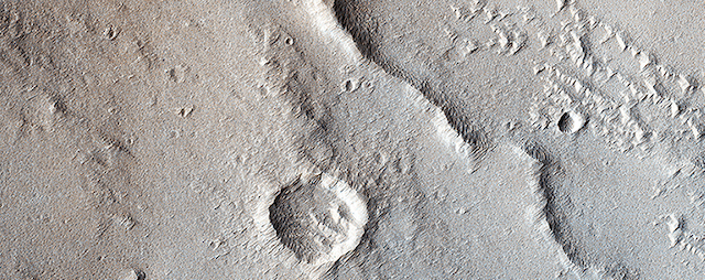
Ten thousand volunteers viewing images of Martian south polar regions have helped identify targets for closer inspection, yielding new insights about seasonal slabs of frozen carbon dioxide and erosional features known as “spiders.”

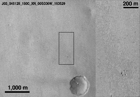
From the comfort of home, the volunteers have been exploring the surface of Mars by reviewing images from the Context Camera (CTX) on NASA’s Mars Reconnaissance Orbiter and identifying certain types of seasonal terrains near Mars’ south pole. These efforts by volunteers using the “Planet Four: Terrains” website have aided scientists who plan observations with the same orbiter’s High Resolution Imaging Science Experiment (HiRISE) camera. HiRISE photographs much less ground but in much greater detail than CTX.

Volunteers have helped identify more than 20 regions in mid-resolution images to investigate with higher resolution. “It’s heartwarming to see so many citizens of planet Earth donate their time to help study Mars,” said HiRISE Deputy Principal Investigator Candice Hansen, of the Planetary Science Institute, Tucson, Arizona. “Thanks to the discovery power of so many people, we’re using HiRISE to take images of places we might not have studied without this assistance.” [More at link]

Posted in Reports | Tagged , , , , , , , , , | Comments Off

MARCI weather report, October 10-16, 2016

marci-oct11-2016A slight increase in local-scale dust activity was observed on Mars last week. Looking to the southern highlands, transient dust storms were spotted over Cimmeria, Sirenum, and Aonia on multiple sols. Local-scale dust activity was also observed propagating southward from Acidalia to Xanthe in the second half of the week. Condensate water-ice clouds persisted along the north polar hood and over Arsia Mons, the… [More at link, including video]

Posted in Reports | Tagged , , , , , , , , , , , , , | Comments Off