HiRISE: Einstein and Mars

ESP_045344_1420
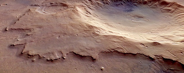
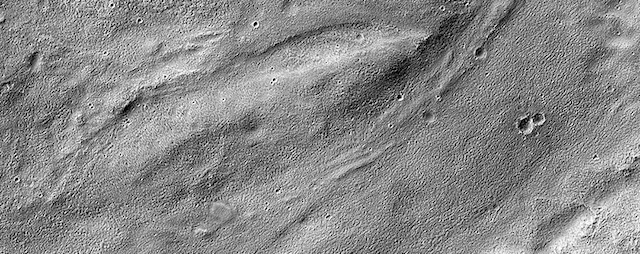
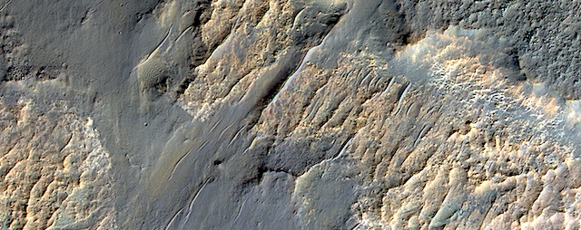
In February 1917, Albert Einstein wrote in a letter: “It is a pity that we do not live on Mars and just observe man’s nasty antics by telescope.” We do have a telescope at Mars, but we use it to image Mars rather than Earth, such as this image of bizarre landforms in Gorgonum Basin.

This basin may have contained an ancient lake, with channels draining into the lake from the sides. After sediments are deposited, they become hardened to varying degrees, then eroded by the wind. More hardened bedrock will remain as high-standing topography following erosion of the weaker materials, perhaps inverting the initial forms. For example… [More at link]

Posted in Reports | Tagged , , | Comments Off

HRSC: MEX spies nameless, ancient impact crater

Mars_Express_spies_a_nameless_and_ancient_impact_crater_node_full_image_2This striking perspective view from ESA’s Mars Express shows an unnamed but eye-catching impact crater on Mars. This region sits south-west of a dark plain named Mare Serpentis (literally ‘the sea of serpents’), which in turn is located in Noachis Terra (literally ‘the land of Noah’).

Noachis Terra is one of the oldest known regions on the Red Planet, dating back at least 3.9 billion years— in fact, the earliest martian era, the Noachian epoch, is named after it. Noachis Terra is representative of ancient Mars’ surface, which is characteristically peppered with craters that have been preserved for billions of years, although many have degraded over time.

The crater visible on the top right of this image is around 4 km deep and 50 km in diameter. At its very centre is a small depression known as a central pit. These are common in craters on rocky worlds throughout the Solar System, especially on Mars, and are thought to form as icy material explosively vaporises and turns to gas in the heat of the initial crater-forming collision. [More at link]

Posted in Reports | Tagged , , , , , , , , , | Comments Off

HiRISE: Glorious glacier

ESP_045334_1350This image has low-sun lighting that accentuates the many transverse ridges on this slope, extending from Euripus Mons (mountains).

These flow-like structures were previously called “lobate debris aprons,” but the Shallow Radar (SHARAD) instrument on MRO has shown that they are actually debris-covered flows of ice, or glaciers. There is no evidence for present-day flow of these glaciers, so they appear to be remnants of past climates. [More at link]

Posted in Reports | Tagged , , , , , , , | Comments Off

THEMIS: Scarp at edge of Olympus Mons

Olympus Rupes (THEMIS_IOTD_20160718)THEMIS Image of the Day, July 18, 2016. Today’s VIS image covers part of Olympus Rupes, the steep escarpment at the edge of Olympus Mons. The left side of the image is the flank of the volcano, the right side is the surrounding volcanic plains. The difference in elevation from the top of the escarpment to the bottom can be as much as 8 kilometers.

More THEMIS Images of the Day by geological topic.

Posted in Reports | Tagged , , , , , , , , , , , , | Comments Off

NASA selects five Mars orbiter concept studies

PIA00407-16NASA has selected five U.S. aerospace companies to conduct concept studies for a potential future Mars orbiter mission. Such a mission would continue key capabilities including telecommunications and global high-resolution imaging in support of the agency’s Journey to Mars.

The companies contracted for these four-month studies are: The Boeing Company in Huntington Beach, California; Lockheed Martin Space Systems in Denver; Northrop Grumman Aerospace Systems in Redondo Beach, California; Orbital ATK in Dulles, Virginia; and Space Systems/Loral in Palo Alto, California.

“We’re excited to continue planning for the next decade of Mars exploration,” said Geoffrey Yoder, acting associate administrator for NASA’s Science Mission Directorate in Washington.

The concept studies will address how a potential new Mars orbiter mission could best provide communications, imaging and operational capabilities. They also will assess the possibilities for supporting additional scientific instruments and functionalities, in addition to optical communications. The orbiter concept under study would take advantage of U.S. industry’s technology capacities by using solar electric propulsion to provide flexible launch, mission and orbit capabilities. [More at link]

Posted in Reports | Comments Off

HiRISE: North polar gypsum dunes

ESP_045501_2605These sand dunes are a type of aeolian bedform and partly encircle the Martian North Pole in a region called Olympia Undae.

Unlike most of the sand dunes on Mars that are made of the volcanic rock basalt, these are made of a type of sulfate mineral called gypsum. Whence the sand? Well, gypsum is a mineral that can often form from the evaporation of water that has sulfur and calcium dissolved in it. This sand was probably sourced from a northern region on Mars that used to be quite wet. The boxy gridding of the dunes indicates that the wind blows in multiple directions. [More at link]

Posted in Reports | Tagged , , , , , , , , , | Comments Off

Curiosity update: Juicy weekend plan

1400MR0068530010701988E01_DXXXSol 1402-04, July 15, 2016, update from USGS scientist Lauren Edgar: It was a slow morning as we anxiously awaited our downlink at 11am this morning… and then we put together a hefty weekend plan.  We’re in late slide sols this week, so planning has been starting later to wait for critical images to come down.  I’m on duty as GSTL today, and we knew it would be a big plan going in to the weekend.  Once we confirmed that the ~26 m drive went well on Sol 1401, our first task was to evaluate the local bedrock and select a target for contact science.  We selected a target named “Uku” for ChemCam, Mastcam, MAHLI and APXS activities to assess the texture and composition of the Murray formation.  We also planned a ChemCam observation on the target “Songo,” a disturbed block which looks more red than some of the surrounding rocks.  The plan also includes some Mastcam mosaics of the “Bimbe” blocky deposit to see if we want to pursue some additional… [More at link]

Posted in Reports | Tagged , , , , , , , , , , , , | Comments Off

Curiosity: Forward…

1401-navcam-forwardSol 1401, July 15, 2016. Two Navcam frames show the drive direction forward toward the southwest. The Murray Buttes lie at the top right edge of the image (click to enlarge).

Sol 1401 raw images (from all cameras), and Curiosity’s latest location.

Posted in Reports | Tagged , , , , , , , , , , | Comments Off

Opportunity: Close-up on Bashful II

4434-miSol 4434, July 15, 2016. The Microscopic Imager swoops in for a four-frame composite of Bashful II rock. (Keep in mind that the sunlight falling on the rock’s surface comes from the upper left.) Click to enlarge.

Opportunity raw images, its latest mission status, a location map. and atmospheric opacity, known as tau.

Posted in Reports | Tagged , , , , , , , | Comments Off

HiRISE: Meandering channel on Hellas’ rim

ESP_045611_1410The central portion of this image features a mildly-winding depression that was carved by water, likely around four billion years ago shortly after the Hellas basin formed following a giant asteroid or comet impact.

Water would have flowed from the uplands (to the east) and drained into the low-lying basin, carving river channels as it flowed. The gentle curves—called “meanders” by geomorphologists—imply that this paleoriver carried lots of sediment along with it, depositing it into Hellas. [More at link]

Posted in Reports | Tagged , , , , , , , , | Comments Off