Hunting for biosignatures in volcanic rocks

feart-07-00091-g005[Editor’s note: From a paper by Magnus Ivarsson, Therese Sallstedt, and Diana-Thean Carlsson recently published in Frontiers in Earth Science.]

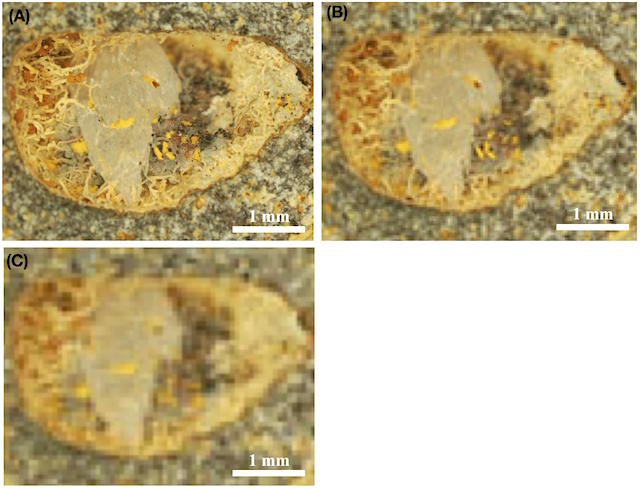
Morphological Biosignatures in Volcanic Rocks – Applications for Life Detection on Mars

The exploration of Mars is largely based on comparisons with Earth analog environments and processes. The up-coming NASA Mars mission 2020 and ExoMars 2020 has the explicit aim to search for signs of life on Mars. During preparations for the missions, glaring gaps in one specific field was pointed out: the lack of a fossil record in igneous and volcanic rock.

Earth’s fossil record is almost exclusively based on findings in sedimentary rocks, while igneous rocks have been considered barren of life, including a fossil record of past life. Since martian volcanic rocks will be targeted in the search for biosignatures, the lack of a terrestrial analog fossil record is an obvious impediment to the scientific aim of the mission.

Here we will briefly review the knowledge of microscopic life in deep rock and deep time. Focus will be on underexplored environments in subseafloor crustal rocks, and on ancient environments harboring early prokaryotic and eukaryotic lineages. We will highlight some of the aspects that need immediate attention and further investigations to meet the scientific goals of the missions.

The current paper is a first step toward the long-term aim to establish an atlas of the fossil record in volcanic rocks, which can be of use for the up-coming space missions. [More at link]

Posted in Reports | Tagged , , , , , , , , , , , , , , , , , , | Comments Off

Mars 2020 is coming together

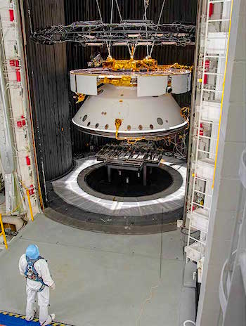
PIA23228-16An engineer inspects the completed spacecraft that will carry NASA’s next Mars rover to the Red Planet, prior to a test in the Space Simulator Facility at NASA’s Jet Propulsion Laboratory in Pasadena, California.

From the top down, and suspended by cables, is the complete cruise stage, which will power and guide the Mars 2020 spacecraft on its seven-month voyage to the Red Planet. Directly below that is the aeroshell (white back shell and barely visible black heat shield), which will protect the vehicle during cruise as well as during its fiery descent into the Martian atmosphere. Not visible (because it’s cocooned inside the aeroshell) is the completed rocket-powered descent stage and the surrogate rover (a stand-in for the real rover, which is undergoing final assembly in JPL’s High Bay 1 cleanroom)…. [More at link]

Posted in Reports | Tagged , , , , , | Comments Off

Curiosity update: Grains, up close!

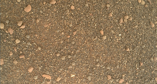
2409MH0006760010900439C00_DXXX-br2Sols 2410-12, May 20, 2019, update by MSL scientist Susanne Schwenzer: Curiosity is continuing the investigations at “Rigg.” The image in this update shows a close up taken by the MAHLI Hand Lens imager to allow the detailed investigation of the materials that make up the field of ripples. Things the team is looking for are grain size and grain size distribution, and the shape of the grains. In addition to that the colour and lustre of the different grain varieties are of interest to allow us to analyse the variation of phases in the sand. One feature to note, for example, are the pinkish grains on the surface, which appear to be larger than all others.

Tosol’s plan is a three-sol plan with many activities imaging the sand ripples and investigating their chemistry. APXS will measure the targets “Nairn” and “Ellon,” to investigate the differences of the different soil colours and grain sizes. ChemCam’s plans include the soil targets “Seafield Tower,” “Saltire” and “Selkirk,” whereby Seafield Tower and Saltire are on ripple crests and Selkirk is on a ripple flank. There also is one rock target to investigate a rock colour variation at the target “Camustianavaig.” [More at link]

Posted in Reports | Tagged , , , , , , , , , , , , , , , , , , , , , , | Comments Off

THEMIS: Basaltic dunes in Firsoff Crater

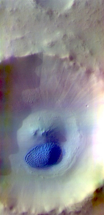
Dunes in Firsoff Crater (THEMIS_IOTD_20190520)THEMIS Image of the Day, May 20, 2019. Today’s false color image shows part of Firsoff Crater, located north of Meridiani Planum. Dark blue tones in the false color filter combination are basaltic sands.

The THEMIS VIS camera contains 5 filters. The data from different filters can be combined in multiple ways to create a false color image. These false color images may reveal subtle variations of the surface not easily identified in a single band image.

Explore more THEMIS Images of the Day by geological subject.

Posted in Reports | Tagged , , , , , , , , , | Comments Off

Curiosity update: Playing in the sand

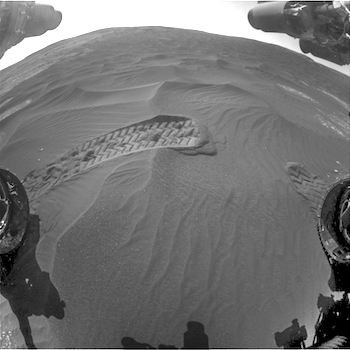
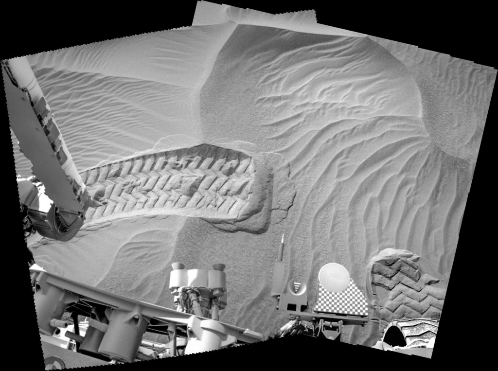
FRB_611270084EDR_F0751564FHAZ00302M_-br2Sol 2409, May 16, 2019, update by MSL scientist Ryan Anderson: The sol 2408 plan ended with the rover using its front wheel to dig a small trench in a ripple at the ripple field named “Rigg.” That means today’s plan is focused on studying what that scuff uncovered. There is a lot that we can learn from these patches of active sand that we occasionally encounter as we explore Gale crater!

One of the big questions is where the sand comes from: by measuring the chemical composition of the sand at Rigg we can compare with sand we have seen earlier in the mission to see if the chemistry is different enough that there must be different sources. We also can compare the grain sizes in different parts of the ripple to get a better understanding of how the wind sorts sand grains under martian gravity and atmospheric pressure.

Studying the shape of the ripples in detail also helps us compare modern bedforms (the generic term for dune-like features of all sizes) to the ancient ones we see preserved in the rocks, which lets us infer similarities or differences in the environment. And of course, looking closely at these wind-blown sand features lets us get a better handle on what the winds are like in Gale crater right now… [More at link]

Posted in Reports | Tagged , , , , , , , , , , , , | Comments Off

Latest weather at Gale Crater and Elysium Planitia

Daily Elysium charts and data (temperature, wind speed, atmospheric pressure) here.

Posted in Reports | Tagged , , , , , , , , , , , , , , | Comments Off

HiRISE: A snow plow landslide

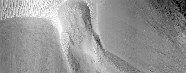
ESP_058960_1800This image shows a small landslide in Iani Chaos. Landslides are common on Mars where there are steep slopes, including this area where there are numerous mounds and hills.

What is unusual about this landslide is that it carved a path downslope as it moved, similar to a snow plow pushing away snow as it moves forward. This image is part of a stereo pair so that scientists will examine the landslide in 3D to understand its formation mechanism. [More at link]

Posted in Reports | Tagged , , , , , , , , | Comments Off

THEMIS: Dune mound in Acidalia Planitia crater

Dune field in Acidalia crater (THEMIS_IOTD_20190517)THEMIS Image of the Day, May 17, 2019. Today’s false color image shows an unnamed crater in Acidalia Planitia. The dark blue feature on the crater floor is a mound of sand. The sand is tall enough to cast a shadow, with the sun is coming from the left (west). The texture on the surface of the sand are dune features created by wind action.

The THEMIS VIS camera contains 5 filters. The data from different filters can be combined in multiple ways to create a false color image. These false color images may reveal subtle variations of the surface not easily identified in a single band image.

Explore more THEMIS Images of the Day by geological subject.

Posted in Reports | Tagged , , , , , , , , , , | Comments Off

MARCI weather report, May 6-12, 2019

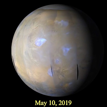
MARCI-May-10-2019We are now well into northern spring, and dust storm activity is picking up in the northern hemisphere. Numerous dust storms were observed near the seasonal north polar cap edge (presently ~60° N) throughout the past week. Several of these storms lifted dust that travelled northward over the residual north polar cap. Several smaller short-lived dust storms were also observed in the south mid-latitudes. Water ice clouds were present throughout the… [More at link, including video]

Posted in Reports | Tagged , , , , , , , , , , , , , , | Comments Off

Curiosity: Ripple studies

2408-navcam-ripplesSol 2408, May 16, 2019. With Curiosity parked at the edge of a field of sand ripples, mission scientists directed the Navcam to image the ripple field leading up to Vera Rubin Ridge (above). Then the camera imaged part of it next to the rover’s side after one of the wheels disturbed it (below). Click either image to enlarge it.

Sol 2408 raw images (from all cameras).

2408-navcam-down

Posted in Reports | Tagged , , , , , , , , , , , , | Comments Off