


 Slope streak cluster formation. These are not RSL, but dark streaks created by dislodged material, such as falling rocks or boulders.
Beautiful Mars series.
Slope streak cluster formation. These are not RSL, but dark streaks created by dislodged material, such as falling rocks or boulders.
Beautiful Mars series.
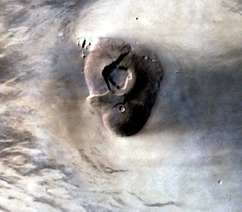 MCC image, taken on September 03, 2015 at an altitude of 6144 km with a resolution of 320 m, shows an intermediate sized shield volcano known as Tharsis Tholus. It is located in the eastern Tharsis region of the planet Mars. The Tharsis Tholus is dome-shaped with flank slopes ranging from less than 1° near the summit to up to 16° at the base. The average flank slope is 10°, making it one of the steepest volcanoes on Mars. The volcano… [More at link]
 Sol 4160, October 7, 2014. Four false-color Pancam frames show the upslope part of Marathon Valley, and yet-uninvestigated geological features. The composite uses false-color images by Holger Isenberg; the lower left image is grayscale. Click to enlarge.
Opportunity raw images, its latest mission status, a location map. and atmospheric opacity, known as tau.
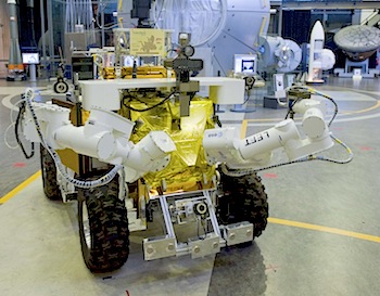 Car trouble is never good – especially on the Red Planet. An actual robotic vehicle experienced wheel failure during a simulated Mars rover journey, in order to test the ability of prototype ‘electronic partners’ to help human astronauts.
“The distance, and consequent signal delay, involved in deep-space missions mean that the kind of realtime mission control currently offered to astronauts in orbit is not possible,” explains ESA’s Mikael Wolff, overseeing the Mission Execution Crew Assistant – Human E-partner Agent Robot Teaming (MECA-Heart) project.
“Instead, we need to find ways of making knowledge and support directly available to the crew, who must make quick decisions about unexpected problems under heavy time pressure, in a hostile environment.
“The approach we are working on involves intelligent electronic partners, called ePartners, which can support crews by not only relating all necessary information but also, by coming to higher-level conclusions, actively support the decision-making process.” [More at link]
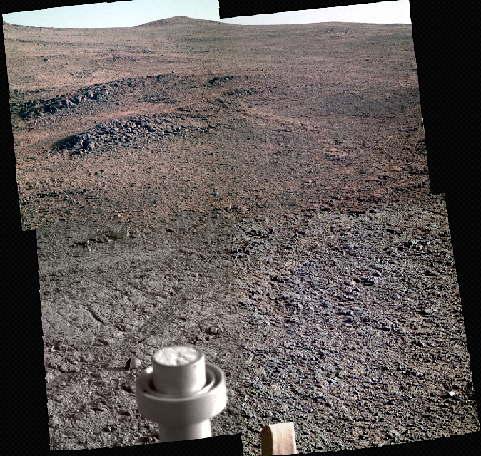
 Sol 1127, October 7, 2015, update from USGS scientist Ken Herkenhoff: Planning is no longer restricted, but to ensure that Sol 1127 commands are ready to be sent to the rover on time, we had to start planning 1.5 hours earlier than usual this morning. The Sol 1126 images show that the APXS was well centered over the pre-sieve dump pile, so we are ready to move on. It’s time for a full set of MAHLI wheel images, which dominate the Sol 1127 plan. After the wheel imaging, there’s just enough… [More at link]
 THEMIS Image of the Day, October 8, 2015. The THEMIS VIS camera contains 5 filters. The data from different filters can be combined in multiple ways to create a false color image. These false color images may reveal subtle variations of the surface not easily identified in a single band image. Today’s false color image shows part of the floor of Melas Chasma. The dark blue region in this false color image is sand dunes.
More THEMIS Images of the Day by geological topic.
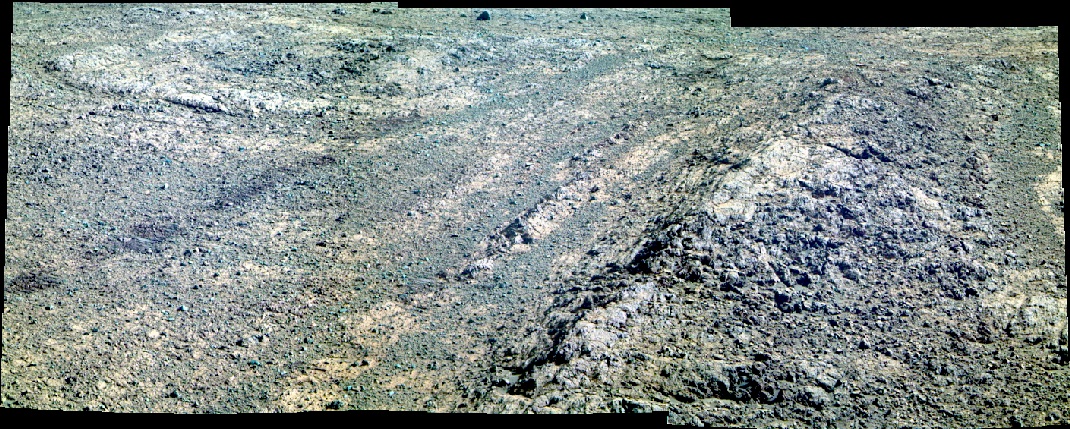
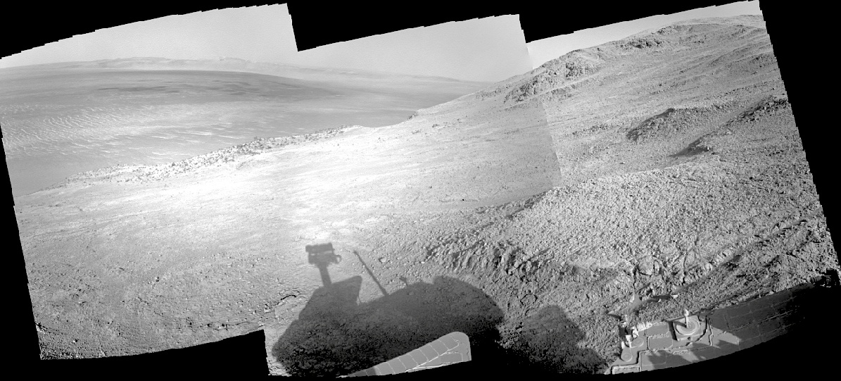 Sol 4159, October 6, 2015. As Opporutnity’s Navcam shot a composite image (above) looking southeast across Endeavour Crater, the Pancam shot a mosaic (below) covering some of the enigmatic patterns in the rock outcrops on the floor of Marathon Valley. (Pancam false-color images by Holger Isenberg.)
As seen from orbit, these rocks showed they contain clay minerals, hallmarks of alteration by water. Mission scientists are eager to map these and study what they can tell of the water history of Endeavour. Click either image to enlarge.
Opportunity raw images, its latest mission status, a location map. and atmospheric opacity, known as tau.
 Living off the land is different when the land is 140 million miles away, so NASA is looking for innovative ideas to use in situ (in place) Martian resources to help establish a human presence on the Red Planet.
The In Situ Resource Utilization Challenge offers the public an opportunity to submit designs for structures on Mars that would use existing material. The agency plans to award $10,000 to the first-place winner, with $2,500 each for two second-place submissions. (…)
The U.S. National Aeronautics and Space Administration (NASA) seeks proposals for systems that will convert in situ materials into interlocking structural elements for construction that can support exploration on a planet. NASA’s focus is to support extra-terrestrial exploration on the Moon or on Mars, but the technology could also be useful on Earth. (…)
Transforming in situ materials such as regolith or basalt into useful structural elements is a significant way to reduce the mass of materials launched as payload from Earth. Considering exploration on Mars, for every kilogram of native materials used, one saves 11 kg of transportation propellant and spacecraft mass required to launch to Low Earth Orbit (LEO). Given the cost for LEO is US$10,000/kg, one avoids at least US$110,000/kg of cost by using 1 kg of in situ materials, making space pioneering on Mars more affordable and feasible… [More at link]
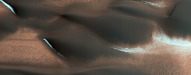 This HiRISE image shows modified barchan dunes with shapes that resemble “raptor claws.” The unusual morphology of these dunes suggests a limited supply of windblown sand.
Winds likely blew from the northeast resulting in elongate dunes with an asymmetric downwind point. The transverse crests of the smaller ripples/mega-ripple bed-forms surrounding the dune, echo the dominant downwind direction towards the southwest. [More at link]
 Sol 1126, October 7, 2015. In four frames shot by the ChemCam’s Remote Micro-Imager (above) we see buttes and layers in the foothills of Mount Sharp. The closeup’s location is shown on the color image below. (Click above image to enlarge.)
Sol 1126 raw images (from all cameras), and Curiosity’s latest location map.
