THEMIS: Candor Chasma – false color

Organized rubble in Candor Chasma (THEMIS_IOTD_20150928)THEMIS Image of the Day, September 28, 2015. The THEMIS VIS camera contains 5 filters. The data from different filters can be combined in multiple ways to create a false color image. These false color images may reveal subtle variations of the surface not easily identified in a single band image. Today’s false color image shows part of the floor of Candor Chasma.

More THEMIS Images of the Day by geological topic.

Posted in Reports | Tagged , , , , , , , , , | Comments Off

RSLs are caused by flows of liquid brines

PIA19917_modestNew findings from NASA’s Mars Reconnaissance Orbiter (MRO) provide the strongest evidence yet that liquid water flows intermittently on present-day Mars.

Using an imaging spectrometer on MRO, researchers detected signatures of hydrated minerals on slopes where mysterious streaks are seen on the Red Planet. These darkish streaks [dubbed recurring slope lineae, or RSLs] appear to ebb and flow over time. They darken and appear to flow down steep slopes during warm seasons, and then fade in cooler seasons. They appear in several locations on Mars when temperatures are above minus 10 degrees Fahrenheit (minus 23 Celsius), and disappear at colder times. [...]

“We found the hydrated salts only when the seasonal features were widest, which suggests that either the dark streaks themselves or a process that forms them is the source of the hydration. In either case, the detection of hydrated salts on these slopes means that water plays a vital role in the formation of these streaks,” said Lujendra Ojha of the Georgia Institute of Technology (Georgia Tech) in Atlanta, lead author of a report on these findings published Sept. 28 by Nature Geoscience. [More at link]

Posted in Reports | Tagged , , , , , , , , , , | Comments Off

Curiosity update: ‘Small drill, Big Sky’

FLB_496475520EDR_F0500592FHAZ00323M_-br2Sol 1116-1118, September 25, 2015, update from USGS scientist Ryan Anderson: It’s time to drill again! After much deliberation, we have decided to try drilling the target “Big Sky” at our current location, in hopes of getting a good sample of relatively unaltered bedrock to compare with some of the altered rocks we have seen nearby.

Sol 1116 is dedicated to doing the mini-start hole, which is how we test if the rock is safe to drill. MAHLI will take documentation… [More at link]

Posted in Reports | Tagged , , , , , , , , , , , , , , | Comments Off

Opportunity: Pvt. Robert Frazer in false color

1P496432456EFFCOCPP2594L5M1_L4L5L5L5L6Sol 4148, September 25, 2015. The rover’s Pancam took a sequence of filtered frames on the target dubbed Pvt. Robert Frazer. Previously, this target was brushed, then drilled by the Rock Abrasion Tool (RAT), which removed the top surface of the outcrop (false-color composite by Holger Isenberg).

The outcrop is part of Opportunity’s survey of the floor of Marathon Valley, as it looks for phyllosilicate (clay) minerals detected by remote sensing from orbit.

Opportunity raw images, its latest mission status, a location map. and atmospheric opacity, known as tau.

Posted in Reports | Tagged , , , , , , , , , | Comments Off

Opportunity prepares for active winter

IDL TIFF fileNASA’s Mars Exploration Rover Opportunity is conducting a “walkabout” survey of “Marathon Valley,” where the rover’s operators plan to use the vehicle through the upcoming Martian winter, and beyond, to study the context for outcrops bearing clay minerals.

Marathon Valley slices downhill from west to east for about 300 yards or meters through the western rim of Endeavour Crater. Opportunity has been investigating rock targets in the western portion of the valley since late July, working its way eastward in a thorough reconnaissance of the area.

The rover’s panoramic camera has captured a scene dominated by a summit called “Hinners Point,” [above] forming part of the valley’s northern edge. The image also shows a portion of the valley floor with swirling reddish zones that have been a target for study. It is online at: http://www.jpl.nasa.gov/spaceimages/details.php?id=PIA19819

For several months starting in mid- to late October, the rover team plans to operate Opportunity on the southern side of the valley to take advantage of the sun-facing slope. [More at link]

Posted in Reports | Tagged , , , , , , , | Comments Off

HiRISE: Layered exposures in southern Argyre

tumblr_nv5kvd2Bxa1rlz4gso2_1280-1Layered exposures in southern Argyre Planitia. Beautiful Mars series.

Posted in Reports | Tagged , , , , , , , , , | Comments Off

Curiosity: At work at Big Sky

1114-hazcamSol 1114, September 24, 2015. The arm moves in on the target dubbed Big Sky, as part of the plan for contact science. (Local time for the animation is 3:52 to 4:30 p.m.)

Sol 1114 raw images (from all cameras), and Curiosity’s latest location map.

Posted in Reports | Tagged , , , , , , , | Comments Off

THEMIS: Mangala Valles

Floods of yesteryear in Mangala Valles (THEMIS_IOTD_20150925)THEMIS Image of the Day, September 25, 2015. This VIS image shows part of the complex channel called Mengala Valles. The tear-drop shaped regions in the channel are called streamlined islands and the narrow “tail” points down stream.

More THEMIS Images of the Day by geological topic.

Posted in Reports | Tagged , , , , , , , , , , | Comments Off

NASA to announce Mars mystery solved, Sept 28

mars20150924-16
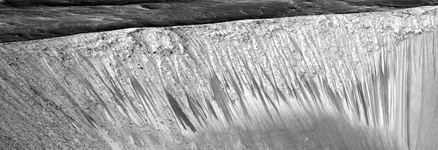
NASA will detail a major science finding from the agency’s ongoing exploration of Mars during a news briefing at 8:30 a.m. PDT (11:30 a.m. EDT) on Monday, Sept. 28. The event will be broadcast live on NASA Television and the agency’s website.

News conference participants will be:
• Jim Green, director of planetary science at NASA Headquarters
Michael Meyer, lead scientist for the Mars Exploration Program at NASA Headquarters
Lujendra Ojha, Georgia Institute of Technology in Atlanta
Mary Beth Wilhelm, NASA’s Ames Research Center in Moffett Field, California, and the Georgia Institute of Technology
Alfred McEwen, principal investigator for the High Resolution Imaging Science Experiment (HiRISE), University of Arizona, Tucson

Members of the public can ask questions during the briefing using #AskNASA. For NASA TV information, schedules and to view the news briefing, visit http://www.nasa.gov/nasatv  The event will also be carried live on http://www.ustream.tv/NASAJPL

For more information about NASA’s journey to Mars
https://www.nasa.gov/topics/journeytomars
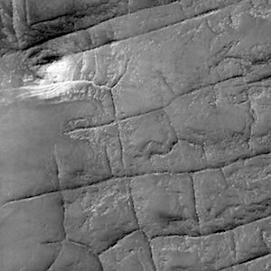
Posted in Reports | Comments Off

Outflow channels: How did source aquifers form, why did they drain so rapidly?

srep13404-f2Gigantic groundwater outbursts created the largest flood channels in the solar system on Mars, 3.2 billion years ago.

For many years it was thought that this was caused by the release of water from a global water table, but research led by J. Alexis P. Rodriguez of the Planetary Science Institute reveals regional deposits of sediment and ice emplaced 450 million years earlier to be the source.

“The flooding is due to regional processes, not global processes,” said Rodriguez, a Senior Scientist at the Planetary Science Institute and lead author of “Martian outflow channels: How did their source aquifers form, and why did they drain so quickly?” that appears in a Nature Scientific Reports. “Deposition of sediment from rivers and glacial melt filled giant canyons beneath a primordial ocean contained within the planet’s northern lowlands. It was the water preserved in these canyon sediments that was later released as great floods, the effects of which can be seen today.” [More at link]

Posted in Reports | Tagged , | Comments Off