Curiosity update: ‘Time for SAM!’

RRB_492839665EDR_F0490814RHAZ00311M_-br2
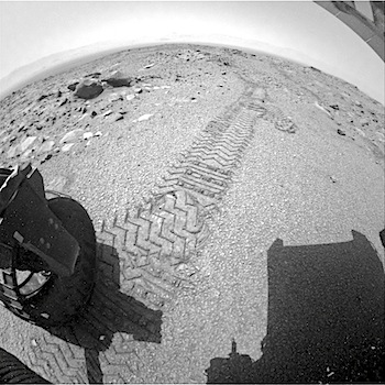
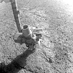
Sol 1075-1077, August 14, 2015, update from USGS scientist Ryan Anderson: We had another successful drive on sol 1074, putting us in a good position for the weekend! The main activity for the weekend is using the Sample Analysis at Mars (SAM) instrument to analyze some of the recent drill sample that we collected. SAM activities will take up all of sol 1075. On sol 1076, we will use MAHLI to check on the health of our wheels, and SAM will do its Evolved Gas Analysis (EGA) measurement on the sample. [More at link]

Posted in Reports | Tagged , , , , , , , , , , , | Comments Off

Opportunity: Micro-imaging Pvt. Robert Frazer

4107-MISol 4107, August 14, 2015. After the rover tested, then RATted a target on the outcrop dubbed Pvt. Robert Frazer, the Microscopic Imager moved in for a close-up. (Composite of two frames; click to enlarge.)

1F492797940ESFCO03P1140R0M1Opportunity raw images, its latest mission status, a location map. and atmospheric opacity, known as tau.

Posted in Reports | Tagged , , , , , , , | Comments Off

HiRISE: Light-toned layers in Tithonium Chasma

ESP_041886_1755Tithonium Chasma is a part of Valles Marineris, the largest canyon in the Solar System. If Valles Marineris was located on Earth, at more than 4,000 kilometers long and 200 kilometers wide, it would span across almost the entire United States. Tithonium Chasma is approximately 800 kilometers long. A “chasma”, as defined by the International Astronomical Union, is an elongate, steep-sided depression.[More at link]

Posted in Reports | Tagged , , , , , , , , , | Comments Off

Curiosity: On beyond Marias Pass

1073-navcamSol 1073, August 13, 2015. This view to the southwest shows the terrain that lies ahead of Curiosity, now that it has left the Marias Pass area. Mount Sharp stands in the distance at the top of the composite image; note the hollow-looking rock outcrop dubbed Crazy Mountain at the lower right edge of the frame. (Click to enlarge.)

Sol 1073 raw images (from all cameras), and Curiosity’s latest location map.

Posted in Reports | Tagged , , , , , , , , | Comments Off

Curiosity update: ‘Crazy Mountain’

NLB_492752040EDR_F0490642NCAM00354M_-br2Sol 1074, August 13, 2015, update from USGS scientist Ryan Anderson: The 47 meter drive on sol 1073 went exactly as expected, putting us in a good position for the sol 1074 plan. It’s a pretty simple plan today, with time for a single ChemCam observation of a target called “Crazy Mountain”. I got to pick the name for this target (one of my favorite parts of being involved in operations), and it seemed fitting since the target is on a big layered block that is tilted at a crazy angle. [More at link]

Posted in Reports | Tagged , , , , , , , , , , , | Comments Off

HiRISE: Yardangs from Apollonaris Patera

ESP_041929_1675We see here a terrain with an incredible morphologic dichotomy: a relatively smooth region that transitions into sharp ridges. These ridges, aligned in the nearly same direction, are called yardangs. Yardangs are not unique to Mars. Many yardangs can be found on Earth, in very dry regions with strong prevailing winds.

Yardangs are formed when a surface that is composed of materials of differing strengths (i.e., of both harder and softer materials) is shaped by the abrasive action of sand and dust carried by the wind. In this case, and given the proximity of the Apollonaris Patera volcanic center, we think that these wind-carved deposits are comprised of volcanic ash and pyroclastics that erupted from Apollonaris when it was last active in the not-too-distant geologic past. [More at link]

Posted in Reports | Tagged , , , , , , , , , , | Comments Off

THEMIS: Keeler Crater dunes – false color

Keeler Crater dune field and haze (THEMIS_IOTD_20150814)THEMIS Image of the Day, August 14, 2015. The THEMIS VIS camera contains 5 filters. The data from different filters can be combined in multiple ways to create a false color image. These false color images may reveal subtle variations of the surface not easily identified in a single band image. Today’s false color image shows dunes of the floor of Keeler Crater in Terra Sirenum.

More THEMIS Images of the Day by geological topic.

Posted in Reports | Tagged , , , , , , , , , , | Comments Off

Opportunity: Late afternoon at Marathon Valley

4106-navcam-afternoonSol 4106, August 13, 2015. Late afternoon sunlight (3:55 pm local time) casts the rover’s shadow eastward and also creates a “hot spot” on the ground. This, on a local scale, is the same opposition effect that makes a Full Moon appear so bright from Earth. Every bit of ground in the down-sun direction is fully lit, with no shadow visible. The image is a composite of two Navcam frames; click to enlarge.

Opportunity raw images, its latest mission status, a location map. and atmospheric opacity, known as tau.

Posted in Reports | Tagged , , , , , , | Comments Off

MAVEN increases its orbital period

11892163_10153703210787868_2141073116225606553_nThe MAVEN navigation team successfully performed a period correction maneuver on Wednesday, August 12, which increased the orbital period of the spacecraft to 4 hours & 38 minutes. This maneuver was performed in order to keep the spacecraft within the required science corridor.

The maneuver was necessary because there is drag or an aerobraking effect exerted on the spacecraft during periapsis (lowest altitude), when MAVEN enters a more dense region of the Martian atmosphere, which can reduce the orbital period. This effect is especially pronounced during the deep-dip campaigns, where the spacecraft flies through a density corridor during periapsis that is twenty to thirty times the atmospheric density encountered during normal science operations. [More at link]

Posted in Reports | Tagged , , , , | Comments Off

HiRISE: Ridge and talus in Lycus Sulci

ESP_041901_2065This image nicely captures several influential geologic processes that have shaped the landscape of Lycus Sulci. Our observation covers an area of about 7.5 by 5.4 kilometers in Lycus Sulci, located just to the northwest of Olympus Mons in the Tharsis region of Mars. “Sulci” is a Latin term meaning “furrow” or “groove.” In this case, Lycus Sulci is a region comprised of a series of depressions and ridges.

Like most of the Tharsis region, Lycus Sulci exhibits thick deposits of light-toned Martian dust; the slopes on ridges in this region feature abundant streaks. These streaks are long, thin dark-toned features. They appear when the superficial light-tone fine-grained materials (i.e., Martian… [More at link]

Posted in Reports | Tagged , , , , , , , , | Comments Off