Opportunity report, Sol 4095, by A.J.S. Rayl, The Planetary Society

20150803_10-Inside-MV-Looking-north-Sol-4087-072315-Pancam-JCanvin
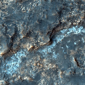
August 3, 2015: Opportunity Enters Marathon Valley, Begins Walkabout: Nearly seven Earth years after the Mars Exploration Rovers mission set its sights on Endeavour Crater, Opportunity cruised into Marathon Valley, the once-but-a-dream destination where orbital data indicate there is a mother lode of bold signs of ancient past water.

“It’s great to be in Marathon Valley,” said Steve Squyres, MER principal investigator, of Cornell University. “It was a long haul. Based on the orbital data, the highest concentration of phyllosilicates we’ve ever seen with either rover is here. Just in terms of what we know about the place from orbit, it’s expected to be scientifically very productive.”

From high overhead, Marathon Valley looks like a notch in the Cape Tribulation segment of Endeavour Crater’s eroded western rim. It stretches generally west to east for some 330 meters (1100 feet), the length of three American football fields, into the big crater… [More at link]

Posted in Reports | Tagged , , , , , , | Comments Off

Curiosity update: ‘Dump pre-sieve sample’

1061ML0046700000306184E01_DXXXSol 1064, August 3, 2015, update from USGS scientist Ken Herkenhoff: The activities planned for last weekend completed successfully, including sample dropoff to CheMin and analysis of the minerals present.  So the Sol 1064 plan includes dumping the portion of the drill sample that has not been sieved and Mastcam, ChemCam, MAHLI, and APXS observations of the dump pile.  ChemCam and Mastcam will also observe nearby targets “Martz” and “Mountain Home.”  MAHLI will image the drill hole, tailings and CheMin inlet at night using its LEDs for illumination. Such nighttime observations require… [More at link]

Posted in Reports | Tagged , , , , , , , , , , | Comments Off

THEMIS: Noachis Terra dunes — false color

Noachis Terra crater dunes (THEMIS_IOTD_20150804)THEMIS Image of the Day, August 4, 2015. The THEMIS VIS camera contains 5 filters. The data from different filters can be combined in multiple ways to create a false color image. These false color images may reveal subtle variations of the surface not easily identified in a single band image. Today’s false color image shows dunes in an unnamed crater in Noachis Terra.

More THEMIS Images of the Day by geological topic.

Posted in Reports | Tagged , , , , , , , , , , | Comments Off

HiRISE: Light-toned outcrops in Eridani Planitia

tumblr_nsiiacIZPN1rlz4gso2_1280Light-toned outcrops in Eridani Planitia. Beautiful Mars series.

Posted in Reports | Tagged , , , , , , , , | Comments Off

Opportunity: Edging down Marathon Valley

4096-navcamSol 4096, August 2, 2015. Opportunity is edging slowly down into Marathon Valley. Three Navcam frames show the valley’s north wall at left and in the distance, the floor of Endeavour Crater, with dunes, both static (light-color, center) and active (dark, at right). Click to enlarge.

Opportunity raw images, its latest mission status, a location map. and atmospheric opacity, known as tau.

Posted in Reports | Tagged , , , , , , | Comments Off

THEMIS: Reull Vallis

Floods of Reull Vallis (THEMIS_IOTD_20150803)THEMIS Image of the Day, August 3, 2015. Today’s VIS image shows a small section of Reull Vallis.

More THEMIS Images of the Day by geological topic.

Posted in Reports | Tagged , , , , , , , , | Comments Off

Curiosity update: ‘Sample dropoff to CheMin’

1060MH0004230000400447R00_DXXXSol 1061-1063, July 31, 2015, update from USGS scientist Ken Herkenhoff: This morning, the MSL operations team was very happy to see that drilling into Buckskin was successful!  The weekend plan therefore has more arm activities, including transferring the sample to the scoop for inspection.  But first, the ChemCam RMI will take pictures of the new drill hole [image at right] and Mastcam will image a potential location for eventually dumping the sample.  The sample will be sieved and a portion of the fine-grained material dropped into CheMin for mineralogical analysis overnight on Sols 1061-1062.  In parallel, the APXS will analyze the potential sample dump location for comparison with future measurements of the dump pile… [More at link]

Posted in Reports | Tagged , , , , , , , , , | Comments Off

Gullies in no-name crater in Utopia Planitia

ESP_041866_2290This enhanced-color image of gullies in the northern wall of an unnamed crater in Utopia Planitia covers an area of approximately 750 by 1100 meters. The banked, sinuous shape of the gully channels suggest that water was involved in their formation. The source of this water however is a subject of debate. Hypotheses include melting of snow or near-surface ground ice.

Other features also suggest the past (and possibly present) presence of snow or ground ice in this region. For example, the “mantle” deposit on the crater wall displays polygonal fractures. Polygons on Earth are associated with periglacial activity. This refers to processes that occur from the presence of ground ice, which interacts with surface and subsurface materials, as well as the Martian atmosphere as a function of climate and seasons). The mantle itself may be the remains of a dusty snowpack deposited in Mars’ recent past. [More at link]

Posted in Reports | Tagged , , , , , , , , | Comments Off

Valleys, deltas, and lacustrine sediment in the southwestern Melas Basin, Valles Marineris

image_2Planetary Geomorphology Image of the Month, July 30, 2015: Joel Davis (University College, London, UK). During the last few decades, dry river valley networks and delta fan structures have been found to be increasingly common on ancient terrains on the martian surface (e.g. Goldspiel and Squyres, 1991; Hynek et al., 2010). They are considered to be one of the main lines of evidence that Mars once had Earth-like precipitation and surface runoff (e.g. Hynek and Phillips, 2003). One such location is the south-western Melas basin, part of a collapsed graben structure on the southern wall of Melas Chasma, Valles Marineris – Mars’ equatorial canyon system. The basin likely formed in the early Hesperian period (~ 3.7 – 3.5 Ga), soon after Melas Chasma opened. [More at link]

Posted in Reports | Tagged , , , , , | Comments Off

THEMIS: Tyrrhena Terra — false color

Tyrrhena Terra false color (THEMIS_IOTD_20150731)THEMIS Image of the Day, July 31, 2015. The THEMIS VIS camera contains 5 filters. The data from different filters can be combined in multiple ways to create a false color image. These false color images may reveal subtle variations of the surface not easily identified in a single band image. Today’s false color image shows a rim of material between two unnamed craters in Tyrrhena Terra.

More THEMIS Images of the Day by geological topic.

Posted in Reports | Tagged , , , , , , , , | Comments Off