HiRISE: Clay-rich terrain in the Eridania Basin

ESP_058610_1515HiRISE reveals small-scale shapes that often correlate with mineral units and provides information about stratigraphy (i.e., what’s on top and relative ages). This image was acquired for co-analysis with a spectrometer instrument also on our spacecraft called CRISM (Compact Reconnaissance Imaging Spectrometer for Mars). It shows polygonal units that match clay-rich areas. Plus, this region is colorful!

This location, in Eridania Basin, was the site of an ancient lake, so these clay-rich sediments may have been habitable.

While CRISM cannot acquire new data from their infrared channel due to lack of cooling, they have acquired much previous data that lacks HiRISE coverage. [More at link]

Posted in Reports | Tagged , , , , , , , , , , | Comments Off

Curiosity update: Luck be an Aberlady

2365ML0125440040900467E01_DXXX-br2Sol 2367, April 3, 2019, update by MSL scientist Michelle Minitti: Our short drive on Monday was successful, bringing two candidate drill targets into closer, clearer view. The prime candidate (image above), “Aberlady,” appeared to have the same color, structure and texture as the Sol 2365 contact science target “Longannet.” The MAHLI and APXS observations from Longannet, and ChemCam observation of the Sol 2365 “Tartan” target, chosen because of its resemblance to Longannet, all fell in family with the range of lithologies we have observed in the clay-bearing unit. That gave the science team confidence that Aberlady was worthy of our first drilling efforts in the clay-bearing unit. However, because it is such an important decision, the science team elected to dedicate today to triaging Aberlady’s structure, texture and chemistry just to be sure. We crammed in as many science… [More at link]

Posted in Reports | Tagged , , , , , , , , , , , , , | Comments Off

THEMIS: Oyama Crater in false color

Oyama Crater in false color (THEMIS_IOTD_20190404)THEMIS Image of the Day, April 4, 2019. Oyama Crater dominates the top of this VIS image. Oyama Crater is located in Arabia Terra, just west of Mawrth Vallis. The two craters at the bottom of the image are unnamed.

The THEMIS VIS camera contains 5 filters. The data from different filters can be combined in multiple ways to create a false color image. These false color images may reveal subtle variations of the surface not easily identified in a single band image.

Explore more THEMIS Images of the Day by geological subject.

Posted in Reports | Tagged , , , , , , , , , | Comments Off

HiRISE: The hills in Juventae Chasma

ESP_058566_1760This image captures some of the geologic diversity of Mars. There are hills of ancient terrains on the floor of Juventae Chasma, surrounded by younger sediments, including dark sand sheets and dunes that are likely active today.

The hills are heavily eroded by landslides, forming gullies in some places. Diverse colors represent unaltered volcanic minerals (blue and green) and altered minerals (brighter and reddish colors). [More at link]

Posted in Reports | Tagged , , , , , , , , , , , | Comments Off

Curiosity: Outcrop workspace

2365-mastcam34Sol 2365, April 2, 2019. Curiosity has driven to where it can examine the outcrop where mission scientists hope to make the next drill hole. (For more about the drill planning, see here.) This composite of six Mastcam (34mm) frames covers the rover’s workspace. Click the image to enlarge it.

Sol 2365 raw images (from all cameras).

Posted in Reports | Tagged , , , , , , , , , , , | Comments Off

MARCI weather report, March 25-31, 2019

MARCI-March-31-2019For the past week on Mars, transient dust storms and water ice clouds continued to develop along the seasonal north polar ice cap edge. Just a bit further south, a couple fleeting dust storms were spotted extending southward across Acidalia and Utopia. Looking to the cratered highlands of the southern hemisphere, a number of local-scale dust-lifting events were observed over Noachis and south of Argyre over the course… [More at link, including video]

Posted in Reports | Tagged , , , , , , , , , , , , , , | Comments Off

THEMIS: Melas Chasma landslide debris

Melas Chasma in false color (THEMIS_IOTD_20190403)THEMIS Image of the Day, April 3, 2019. This false-color image is located within Melas Chasma. The lobate forms at the bottom of the image are the remnants of landslides that crashed from the top of the cliff sides to the bottom of the chasma, a distance of 9 kilometers (5.5 miles). This is equivalent to the height of Mount Everest – the tallest land based mountain in the world.

The THEMIS VIS camera contains 5 filters. The data from different filters can be combined in multiple ways to create a false color image. These false color images may reveal subtle variations of the surface not easily identified in a single band image.

Explore more THEMIS Images of the Day by geological subject.

Posted in Reports | Tagged , , , , , , , , , , , | Comments Off

Curiosity update: Edging closer and closer to a new drill target!

FLB_607358066EDR_F0751350FHAZ00302M_-br2
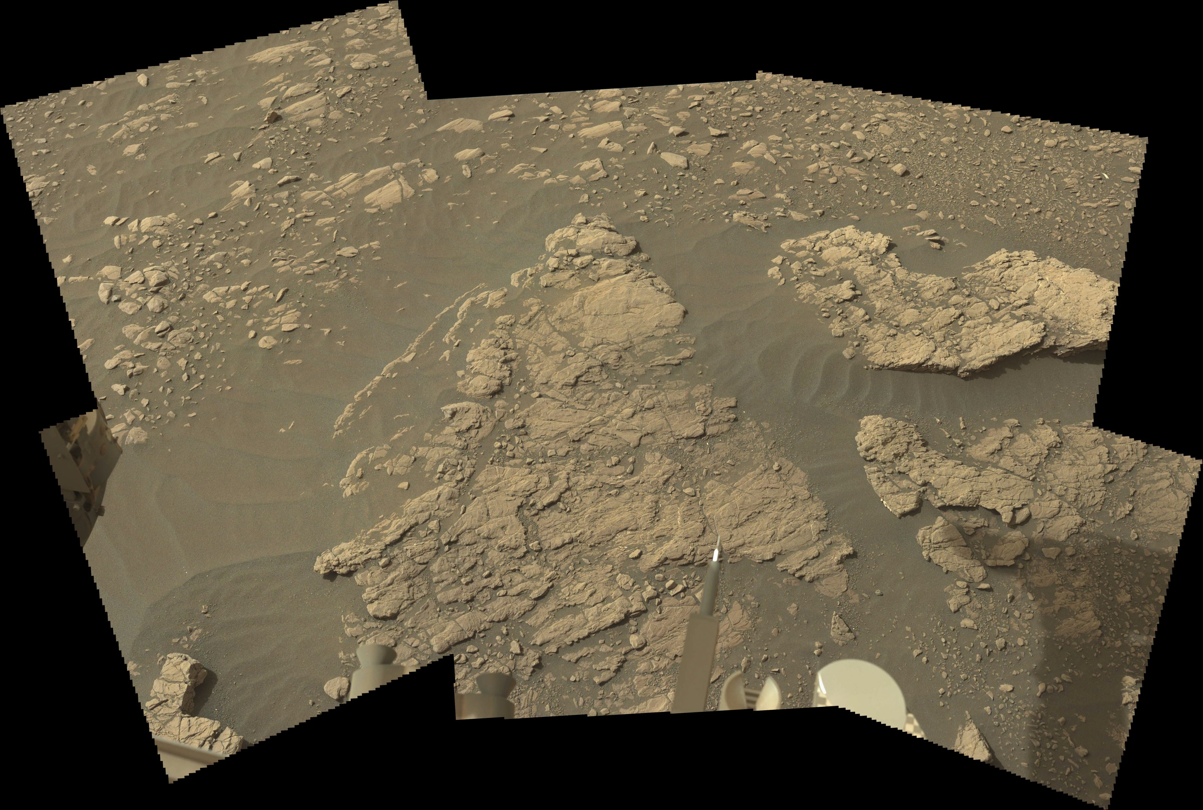
Sols 2365-66, April 2, 2019, update by MSL scientist Catherine O’Connell-Cooper: One of the primary goals of the Curiosity mission, to determine the composition of a region which appears to be rich in clays (informally known as “Glen Torridon”), is getting closer to being achieved. Our weekend drive was designed to bring us to an area of flat-lying bedrock, which we had hoped might contain a drillable surface. At the start of planning, we were very excited to see a larger, flat slab of bedrock towards the back of this outcrop, so we decided to maneuver around to that end of the outcrop, so that we can assess the suitability of this rock as a drill target.

First, we will categorize the composition of the bedrock from the position that we are in. APXS will analyze “Longannet” to ensure that we are still within our desired compositional range, and MAHLI will image this target, for comparison to previous targets. ChemCam will analyze a comparable target called “Tartan.” Mastcam will image Tartan and “Lumphanan,” which may be a fragment of an iron meteorite.

We then make a short drive (<15 meters) to the other side of this outcrop and take Mastcam imaging of the potential drill site. This will allow the engineers and rover planners at JPL to examine the bedrock in more detail and assess its suitability for drilling (for example, looking at rock coherency, presence of veins, homogeneity of the surface). These images will be downlinked ahead of the start of planning on Wednesday, so that we can make an informed decision. A key activity in this two-sol plan will be to clean the gas column in the “Sample Analysis at Mars” instrument (SAM), in advance of drilling and analyzing a new target… [More at link]
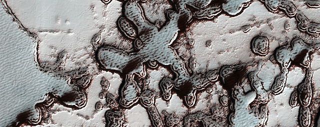
Posted in Reports | Tagged , , , , , , , , , , , , , , | Comments Off

Curiosity: Mastcam looks ahead

2364-mastcam34Sol 2364, April 1, 2019. The rover’s Mastcam (34mm lens) looked ahead across the Glen Torridon clay-bearing unit, with Mt. Sharp rising in the distance and the southern side of Vera Rubin Ridge at left. These five frames are part of a big, but incomplete composite showing the terrain in the area. Click the image (4.3 MB) to enlarge it.

Sol 2364 raw images (from all cameras).

Posted in Reports | Tagged , , , , , , , , , , , | Comments Off

HiRISE: Dramatic changes over the south polar cap

ESP_058515_0955The south polar residual cap of carbon dioxide ice rapidly changes. This image was planned as an almost exact match to the illumination and viewing angles of a previous one we took in August 2009.

The pits have all expanded and merged, and we can just barely see the patterns in the 2009 image compared to this January 2019 picture. The 2009 image is also brighter and bluer, with more seasonal frost and/or less dust over the surface. These images were both taken in late southern summer, but our 2019 picture is slightly later in the Martian season by about two weeks… [More at link]

Posted in Reports | Tagged , , , , , , , , , | Comments Off