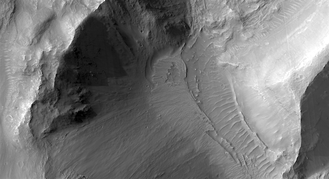
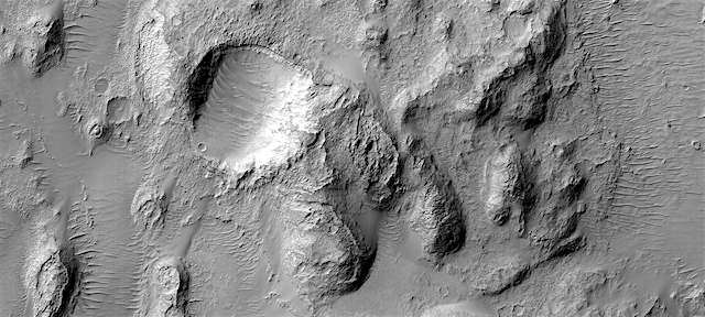
THEMIS: Northern Terra Sabaea in false color

Terra Sabaea hills in false color (THEMIS_IOTD_20190325)
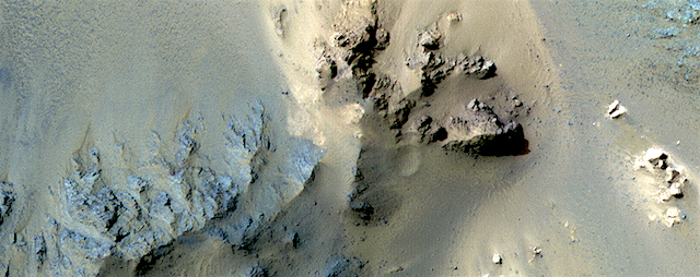
THEMIS Image of the Day, March 25, 2019. This false-color VIS image shows part of northern Terra Sabaea. Blue tones in false-color images usually indicate basaltic sand.

The THEMIS VIS camera contains 5 filters. The data from different filters can be combined in multiple ways to create a false color image. These false color images may reveal subtle variations of the surface not easily identified in a single band image.

Explore more THEMIS Images of the Day by geological subject.

Posted in Reports | Tagged , , , , , , , , , , , | Comments Off

Curiosity update: Clay-bearing unit showing us its stripes?

NLB_606480268EDR_F0750456NCAM00354M_-br2Sols 2354-58, March 23, 2019, update by MSL scientist Michelle Minitti: As Curiosity makes her way to the site where the science team would like to drill next, there is no shortage of observations to make of the many different lithologies of the clay-bearing unit. On Sol 2354, we were greeted with a pebble-dominated workspace, and had the opportunity for a quick contact science analysis with MAHLI and APXS before driving on. However, the rover wake up time was late enough in the morning that the temperature would have been a bit too warm for APXS to yield its best data. While it is ideal for MAHLI and APXS to work together, the team still thought it valuable to acquire MAHLI images of pebbles (the target “Gigha,” a collection of red-and-gray rock fragments of various shapes ranging from ~1-4 cm in size) in the workspace to investigate their texture and grain size at the… [Lots more at link]

Posted in Reports | Tagged , , , , , , , , , , , , , , , , , , , , | Comments Off

HiRISE: Deposits along the floor of Coprates Catena

ESP_054715_1650Deposits along the floor of Coprates Catena. The rest of this depression has very interesting layered deposits so we’re interested to see if there could be some here too. Coprates Catena is roughly in the center of the Valles Marineris canyon system.

HiRISE Picture of the Day archive [More at links]

Posted in Reports | Tagged , , , , , , , , , , , , | Comments Off

Episodic upwelling and layered deposits in Kotido Crater, Arabia Terra

figure_7[Editor’s note: From a paper by Monica Pondrelli and six co-authors recently published in the Journal of Geophysical Research.]

Groundwater Control and Process Variability on the Equatorial Layered Deposits of Kotido Crater, Mars

• We mapped the Equatorial Layered Deposits of Kotido crater, recognizing their geological variability and stratigraphic relations
• Fluid expulsion processes controlled by groundwater fluctuations appear to be the driving mechanism on the deposition/preservation
• The importance of groundwater control raises issues on the possible lateral relations with other deposits/morphologies in Arabia Terra

Light‐toned layered deposits rich in sulfates are widespread on Mars in several locations. Understanding how these deposits formed is crucial to infer the climatic conditions during Martian history and, in light of the fact that potentially similar deposits on Earth have been shown to be conducive to bacterial life, is critical in the search for habitable environments on Mars. We focused on Kotido crater because it shows a remarkable infill and excellent data coverage. We drew a detailed geological map, recognizing subunits interbedded within the layered deposits: light‐toned and darker‐toned layers, subconical mounds, and associated fractures.

We interpret these materials to result from episodes of water upwelling sourced from the subsurface: a mixture of fluids, gases, and sediments emerged in Kotido leading to the deposition of the different subunits depending on the relative ratio of the upwelling materials in the different phases. The mounds and fractures would represent the morphological expression of the upwelling process, while the light‐ and darker‐toned material would represent the resulting deposits. The proposed mechanism is identical to that of terrestrial environments such as playa and spring deposition typical of arid settings where bacterial life is well adapted. [More at link]

Posted in Reports | Tagged , , , , | Comments Off

Curiosity: Driving onward into Glen Torridon

2354-navcam-frontSol 2354, March 21, 2019. Two Mastcam pans, one looking forward, the other behind. Click either image to enlarge it.

Sol 2354 raw images (from all cameras).

2354-navcam-rear

Posted in Reports | Tagged , , , , , , , , , , | Comments Off

HiRISE: Bedrock in the central peaks of Hale Crater

ESP_058618_1445This long image is entirely over the extensive central peak complex of Hale Crater.

Of particular interest are bedrock outcrops and associated fine-grained sediments with different colors. This 153-kilometer diameter crater was named after American astronomer George Ellery Hale. [More at link]

Posted in Reports | Tagged , , , , , , , , | Comments Off

THEMIS: Tapestry in rock — Daedalia Planum

Daedalia Planum tapestry of rock (THEMIS_IOTD_20190322)THEMIS Image of the Day, March 22, 2019. This VIS image shows a small portion of Daedalia Planum. The lava flows in this image originated at Arsia Mons. Individual flows have lengths up to almost 180 km (~111 miles). The longest Hawaiian lava flow is only 51 km (~31 miles).

The area of Daedalia Planum is 2.9 million square km – more than four times the size of Texas.

Explore more THEMIS Images of the Day by geological subject.

Posted in Reports | Tagged , , , , , , , , , , | Comments Off

HiRISE: Holden Crater impact ejecta

ESP_054714_1550Holden Crater impact ejecta. Because Holden is such a massive crater (about 140-km in diameter), its ejecta certainly covers a wide area. This image focuses on a small portion of it, where we can see some diverse compositions.

HiRISE Picture of the Day archive [More at links]

Posted in Reports | Tagged , , , , , , , , , , | Comments Off

Curiosity: Mastcam view of Glen Torridon

2352-mastcam34Sol 2352, March 19, 2019. Leaving the rock named Muir of Ord behind, and following a drive of about 30 meters (almost 100 feet), Curiosity’s wide-angle Mastcam shot a five-frame view looking at the terrain ahead.

The rover is on the clay-bearing unit, also dubbed the Glen Torridon member of the Murray Formation. The south side of Vera Rubin Ridge forms the skyline, with a glimpse of Mt. Sharp’s lower slopes visible in the distance at right. Click the image (6.7 MB) to enlarge it.

Sol 2352 raw images (from all cameras).

Posted in Reports | Tagged , , , , , , , , , , , | Comments Off

ExoMars rover landing platform gets a name

ExoMars_surface_platform_packed_for_EuropeThe platform destined to land on the Red Planet as part of the next ExoMars mission has arrived in Europe for final assembly and testing – and been given a name.

An announcement was made by the Russian State Space Corporation Roscosmos of its new name: ‘Kazachok’.

The ExoMars programme is a joint endeavour between ESA and Roscosmos and comprises two missions. The Trace Gas Orbiter is already circling Mars examining the planet’s atmosphere, while the second mission – comprising a surface science platform and a rover – is foreseen for launch in 2020.

Last month, the rover was named ‘Rosalind Franklin’ after the prominent scientist behind the discovery of the structure of DNA. Now the surface platform also has a name. Kazachock literally means little Cossack, and it is a lively folk dance.

Once on the martian surface, Rosalind the rover will drive off the Kazachok platform to perform scientific investigations. Kazachok will remain stationary to investigate the climate, atmosphere, radiation and possible presence of subsurface water in the landing site… [More at link]

Posted in Reports | Tagged , , , , , , , , , | Comments Off