THEMIS: Tectonic scars in Sirenum Fossae

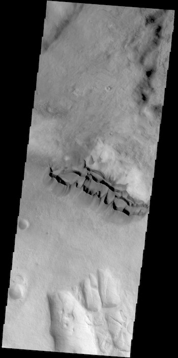
Graben in Sirenum Fossae (THEMIS_IOTD_20190114)THEMIS Image of the Day, January 4, 2019. The linear features in this VIS image are graben called Sirenum Fossae. Graben are formed when blocks of material move downward between parallel faults.

The faults were created by tectonic stresses in this region. The ground is pulling apart and breaks into faults, continued stress moves the sides of the faults further apart and form the graben.

See more THEMIS Images of the Day by geological subject.

Posted in Reports | Tagged , , , , , , , , , , | Comments Off

Weather at Gale Crater

Posted in Reports | Tagged , , , , , , , | Comments Off

THEMIS: Terra Sirenum crater dunes

Terra Sirenum crater dunes (THEMIS_IOTD_20190103)THEMIS Image of the Day, January 3, 2019. Dark dunes fill part of the floor of this unnamed crater in Terra Sirenum. There are numerous gullies on the rim of the crater.

Winds are moving the sand towards the upper left of this image, filling the lower sections of many gullies.

Meanwhile, the gullies in the southern (bottom) part of the crater show signs of pasted-on terrain, which may be dust-covered snow or ice.

See more THEMIS Images of the Day by geological subject.

Posted in Reports | Tagged , , , , , , , , , , | Comments Off

Phobos grooves produced by rolling boulders

video-1-blog-display-image[Ed. note: This research was described previously here.]

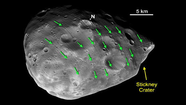
Planetary Geomorphology Image of the Month, January 1, 2019: Kenneth Ramsley (Brown University). All but one region of Phobos, the largest moon of Mars, is covered by hundreds of valley-like features, usually described as grooves. Most grooves are ~80 to ~200 meters wide and are found in groups of generally parallel members, or families [see Image 1].

Impact craters typically produce slow-moving boulders, and on Phobos there would be little gravity to halt their motions. Did boulders rolling across the surface of Phobos produce the grooves? To answer this question, using a computer model to calculate the fate of rolling boulders, we compare their motions to the geomorphology of the grooves… [More at link, including videos illustrating the computer model]

Posted in Reports | Tagged , , | Comments Off

MARCI weather report, December 24-30, 2018

MARCI-December-30-2018Storm activity remained active for the northern hemisphere of Mars this past week. Dust-lifting along the Acidalia storm-track, which started in the previous week, continued south into Aonia Terra. During that time, a subsequent dust storm was spotted over Chryse and pushed southward towards Margaritifer Terra by week’s end. Concentrating on the lowlands, the plains of Amazonis and Utopia experienced multiple…  [More at link, including video]

Posted in Reports | Tagged , , , , , , , , , , , , , , | Comments Off

THEMIS: Dust devil tracks in Promethei Terra

Dust devil tracks in Promethei Terra (THEMIS_IOTD_20190102)THEMIS Image of the Day, January 2, 2019. This VIS image shows a region dense with dust devil tracks (and several pedestal craters).

Located in Promethei Terra, these tracks run parallel to the nearby southeastern margin of Hellas Planitia. The number of tracks and amount of overlapping indicates that there are long term winds in this region.

See more THEMIS Images of the Day by geological subject.

Posted in Reports | Tagged , , , , , , , , , , | Comments Off

THEMIS: South polar ice cap layers

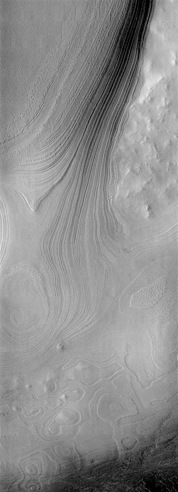
Polar  ice cap layers (THEMIS_IOTD_20181231)THEMIS Image of the Day, December 31, 2018. This VIS image is located along the edge of the south polar cap.

In the upper right corner the non-polar surface is visible. The tightly packed layers to the left are the edge of the polar cap, a very steep cliff-like feature.

At the bottom half of the image is a surface where some, but not all, of the polar layers have been eroded away.

This surface illustrates how the polar layering forms, filling in the low regions first until all the topography is covered.

See more THEMIS Images of the Day by geological subject.

Posted in Reports | Tagged , , , , , , , , | Comments Off

Dunes decrease in size at high southern latitudes, likely from ground ice cementation

figure-2[Editor’s note: From a paper by Maria Banks and seven co-authors recently published in the Journal of Geophysical Research.]

Patterns in Mobility and Modification of Middle‐ and High‐Latitude Southern Hemisphere Dunes on Mars

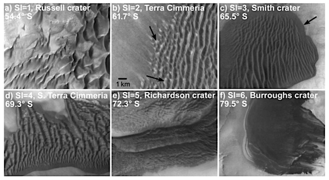
• The mobility of dunes and ripples decreases with increasing latitude and degradation for southern hemisphere Martian dune fields
• A marked shift toward reduced bedform activity and widespread dune degradation begins poleward of ~60°S latitude
• Results support stabilization of sand sediments, likely by polar processes such as accumulating ground ice

Dune fields and sand sheets, very similar to those we see on Earth, are observed on the surface of Mars. Their presence attests to the importance of wind-driven activity in shaping the Martian surface. Using repeated high-resolution imaging with the HiRISE (High Resolution Imaging Science Experiment) camera in orbit around Mars on the Mars Reconnaissance Orbiter spacecraft, we can now look closely at dunes and ripples (collectively referred to as bedforms) on Mars to find evidence of changes over time. (…)

In this study, we investigated the activity of dunes and ripples in the middle and high latitudes of the southern hemisphere of Mars. We combined our results with those from investigations that looked at how the bedforms are degrading and being modified from nonwind-driven processes, indicative of dune inactivity.

Our results show that dunes and ripples are progressively less active and show increasing evidence of degradation and erosion with proximity to the south pole… [More at link]

Posted in Reports | Tagged , , , , | Comments Off

THEMIS: Dunes on the move in Aonia Terra

Dunes on the move (THEMIS_IOTD_20181228)THEMIS Image of the Day, December 28, 2018. Located in the center of this VIS image is a group of sand dunes. With enough wind and sand, sand dunes are formed.

Dune morphology typically has a shallow slope on the side the wind is blowing from and a steep face on the other side. The darker part of the dunes in this image are the steep slopes. Wind blows sand particles up the shallow slope and then the particles fall off the crest of the dune down the steep side. With time, the constant wind will move the crest of the dune forward.

Depending on the amount of available sand, dunes can grow to large heights and sizes. In the case of this image, the dunes are moving toward the top of the image, which means up the surface slope. In cases such as this, the dunes climb up hills.

See more THEMIS Images of the Day by geological subject.

Posted in Reports | Tagged , , , , , , , , , | Comments Off

Highland landscapes point to long evolution by low-intensity intermittent erosion

figure-2[Editor’s note: From a paper by Jon Cawley and Ross Irwin recently published in the Journal of Geophysical Research.]

Evolution of Escarpments, Pediments, and Plains in the Noachian Highlands of Mars

Debris-mantled escarpments, regolith pediments, sloping aggradational surfaces, and depositional plains developed on Martian cratered terrain

Noachian arid-zone geomorphology included aqueous weathering of basalt to fines, low-intensity fluvial erosion, and deposition in basins

These processes smoothed and sealed Noachian ejecta blankets, which required little geomorphic work to form stable pediments

The surface of Mars at Libya Montes, Noachis Terra, and Terra Cimmeria includes steep eroded slopes, gently to moderately sloping stable surfaces, gently sloping low areas that were thinly buried, and flat‐floored basins that accumulated thick deposits of sediment. The development of these surface features suggests low‐intensity, intermittent erosion by running water and wind over hundreds of millions of years.

The key elements of this landscape evolution include weathering of Martian basaltic bedrock to finer‐grained sediments rather than coarse gravel, a lack of intense rainfall or snowmelt, minimal movement of loose material downslope, and processes that concentrated sediment in basins. The blankets of material ejected from impact craters required little erosion to form stable and better sealed surfaces, which were later eroded by rivers during brief wetter epochs of Martian history. [More at link]

Posted in Reports | Tagged , , , , , , , | Comments Off