MARCI weather report, December 17-23, 2018

MARCI-December-22-2018A slight uptick in dust-lifting activity was observed last week on Mars. Dust storms over Acidalia Planitia pushed southward along the storm-track towards eastern Valles Marineris. Meanwhile, the plains of Amazonis, Arcadia, and Utopia encountered repeated local-scale dust storms. Looking to the southern hemisphere, dust storm activity continued to be diminished over the course of the week. Diffuse water ice clouds… [More at link, including video]
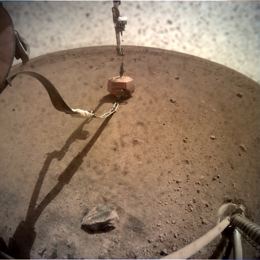
Posted in Reports | Tagged , , , , , , , , , , , , , , , | Comments Off

THEMIS: Tectonic chaos in Claritas Fossae

Tectonic chaos in Claritas Fossae (THEMIS_IOTD_20181227)THEMIS Image of the Day, December 27, 2018. Located between the lava plains of Daedalia Planum and Solis Planum, Claritas Fossae is a graben-filled highland.

Graben are formed by tectonic activity. In this region of Mars extensive and long lived volcanic and tectonic activity created the largest volcanoes and the longest canyon system on Mars.

Volcanic and tectonic forces coexist and tectonic faults are often utilized by subsurface magma to reach the surface. Claritas Fossae was formed prior to the large lava flows of the Tharsis region.

See more THEMIS Images of the Day by geological subject.

Posted in Reports | Tagged , , , , , , , , , , , , | Comments Off

InSight update, Sols 1-24, by Emily Lakdawalla, The Planetary Society

20181220_C000M0023_598578217EDR_F0000_0800M__f840It’s been a busy first three weeks on the InSight mission, and they’ve already achieved a major milestone: placing the seismometer on the ground. In this post I’ll give a few brief highlights of the latest mission activities, and then go into absurd detail about mission operations and engineering. Thanks very much to principal investigator Bruce Banerdt for an informative interview full of the kinds of details that Mars geeks will love.

According to a post-deployment update posted to the JPL website, the seismometer has been placed about as far away from the lander as the arm can reach, 1.636 meters away. The next step in the long process of setting up InSight’s experiments is to level the seismometer; its placement spot has a very gentle slope of 2-3 degrees. They may (or may not) also nudge the tether ribbon slightly to minimize the noise it contributes to seismometer measurements (more on that below). After that, they’ll place a lid over the seismometer to shield it from wind, daytime heat, and nighttime cold. They expect to have the heat probe placed on the ground, about 1.2 meters to the left of the seismometer, by late January…. [More at link]

Posted in Reports | Tagged , , , , , , , , , | Comments Off

THEMIS: Lava flow fronts in Daedalia Planum

Daedalia Planum lava flow fronts (THEMIS_IOTD_20181226)THEMIS Image of the Day, December 26, 2018. Today’s VIS image shows a small portion of the immense lava flows that originated from Arsia Mons.

Arsia Mons is the southernmost of the three large aligned volcanoes in the Tharsis region. Arsia Mons’ last eruption was 10s of million years ago. The youngest volcano in the region is Olympus Mons, which is also the largest volcano in our solar system.

See more THEMIS Images of the Day by geological subject.

Posted in Reports | Tagged , , , , , , , , , , , , | Comments Off

THEMIS: Clouds over south polar cap layers

South polar cap clouds (THEMIS_IOTD_20181225)THEMIS Image of the Day, December 25, 2018. This line of clouds is located over the ice of the south polar cap.

At the time of year when this VIS image was collected (southern hemisphere summer), clouds are a common occurrence.

See more THEMIS Images of the Day by geological subject.

Posted in Reports | Tagged , , , , , , , , , , | Comments Off

THEMIS: Sand sheet in Halley Crater

Sheet of dunes in Halley Crater (THEMIS_IOTD_20181224)THEMIS Image of the Day, December 24, 2018. This VIS image shows part of the dune field on the floor of Halley Crater.

Rather than small individual sand dunes, the sand here is collected into a sand sheet and dune forms have been created on that surface. Halley Crater is located on the western margin of Argyre Planitia.

See more THEMIS Images of the Day by geological subject.

Posted in Reports | Tagged , , , , , , , , , , , , | Comments Off

Curiosity update: Capturing light into the new year

2264MR0121100030106597C00_DXXSols 2276-78, December 21, 2018, update by MSL scientist Fred Calef: As we cross the winter solstice and daylight lengthens here on Earth, the Vera Rubin Ridge campaign on Mars is shortening up towards a science-filled end ‘capturing the light’ across all its splendid spectrum. On sol 2276, the plan includes a CheMin analysis to illuminate the drill sample “Rock Hall” in X-ray light, staring at the plasma glow from the ultra violet through the visible into the near infrared (what you see with your eyes and slightly beyond) from ChemCam on bedrock targets “Auchenheath,” “Firth of Forth,” and “Port Charlotte” as well as a panchromatic (artsy black and white) RMI mosaic of the large white vein “Hopetoun.” All these targets also get viewed in their red-green-blues (i.e. color) using Mastcam… [More at link]

Posted in Reports | Tagged , , , , , , , , , , , , , , , | Comments Off

Weather at Gale Crater

Posted in Reports | Tagged , , , , , , , | Comments Off

NASA Mars Report, December 20, 2018

Posted in Reports | Tagged , , , , , , , , , , | Comments Off

InSight: Lander has its SEIS on the ground

C000M0024_598663736EDR_F0000_0461M_Sol 24, December 21, 2018. This view was taken through the dust-spattered lens of the Instrument Context Camera and shows the deployed SEIS seismometer on the ground in front of the lander.

Each ICC image has a field of view of 124 x 124 degrees. Click the image to enlarge it.

Raw images (in .PNG format) here.

Posted in Reports | Tagged , , , , , , , , , | Comments Off