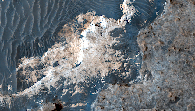
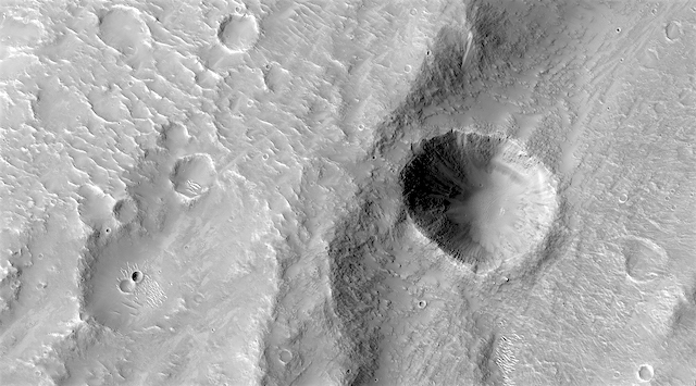
HiRISE: Finding the plume

ESP_055018_1885
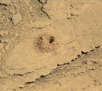
Finding the plume. We hope to determine source and identity of a unique material emission “plume” from inside a corner of this crater, which is being dispersed 60-plus miles “downwind” from this location.

HiRISE Picture of the Day archive. [More at links]

Posted in Reports | Tagged , , , , , , , , , , | Comments Off

Are scarps on Mars oriented by wind erosion?

figure_1[Editor’s note: From a paper by Joshua Williams and three co-authors recently published in Icarus.]

Scarp orientation in regions of active aeolian erosion on Mars

• Scarps were analyzed in two regions of active aeolian erosion on Mars.
• No robust correlation between wind direction and scarp orientation was identified.
• Competing controls on scarp orientation likely include wind, impacts, and thermal stress.

The morphologies of wind-formed features on Mars provide diagnostic information about ancient and modern surface winds. Aeolian erosional features include decimeter-scale ventifacts and kilometer-scale yardangs, but intermediate-scale erosional features are less well-understood.

Understanding aeolian erosion may be critical to identifying ancient martian biosignatures. Cosmogenic radiation destroys complex organic molecules during prolonged exposure at the martian surface, but outcrops freshly re-exposed by aeolian erosion provide potential sites where biosignatures could have been protected and made recently available for sampling. Wind-driven scarp retreat has been cited as the cause for young exposure ages measured in Gale crater.

Upcoming exploration by the Mars 2020 rover will focus on Jezero crater, another location of extensive aeolian erosion and meter-scale scarps. This work is motivated by the hypothesis that retreating scarps on Mars may prefer orientations that reflect the direction of erosive winds.

We mapped scarps in Jezero and Gale craters and compared their orientation distributions with local wind regimes interpreted from other aeolian indicators.No strong correlation between wind direction and scarp orientation was identified. The near-random distribution of scarp orientations suggests that in the locations studied the dominant processes controlling scarp orientation are either processes that do not prefer an orientation (e.g., impact or thermal fracturing processes), or that turbulent flow structures form at the scale of scarp topography and obscure the regional-scale signals of erosion with scarp-scale eddies and flow deflection. [More at link]

Posted in Reports | Tagged , , , , , | Comments Off

THEMIS: At the north polar cap’s edge

North polar cap edge (THEMIS_IOTD_20190807)THEMIS Image of the Day, August 7, 2019. Today’s VIS image is located on the edge of the polar cap. The ice is located at the bottom of the frame, with the surrounding plains at the top half.

The circular indentation in the ice margin is affecting the local winds, creating an area of sand dunes.

Explore more THEMIS Images of the Day by geological subject.

Posted in Reports | Tagged , , , , , , , , , | Comments Off

Curiosity update: Success on the 22nd drill hole; happy landing day — on to year 8!

2486MR0132080010404946E01_DXXX-br2Sol 2488, August 5, 2019, update by MSL scientist Roger Wiens: On Sunday morning the team received the message that Curiosity’s latest drill hole was successful at “Glen Etive.” This is the 22nd full-depth drill hole on Mars, and we can celebrate its success on this final day of Earth-year 7 of the mission. “Glen Etive” is the third hole in the clay unit. The other two holes, “Kilmarie” and “Aberladie,” were drilled near each other in April at a lower stratigraphic position. This hole was achieved with no percussion, and its depth is > 4 cm. Tailings from the drill hole will be used for analyses of this outcrop by the SAM and CheMin instruments. The tailings will also be characterized by APXS, MAHLI, Mastcam, and ChemCam.

The operations and analysis surrounding a drill activity are well scripted, though not always easy. In today’s plan, ChemCam will attempt to shoot down into the drill hole to analyze the rock layers on the wall of the hole. These are fresh rock surfaces and should generally represent the same material that SAM and CheMin analyze. It is dark in the hole, so the autofocus feature of ChemCam is significantly challenged. Getting a good image down the hole requires overexposing the other parts of the image so we can see better in the dark part of the hole. Early in the mission during my public talks, I would demonstrate the pointing accuracy needed to do this activity by tossing a dime down on the stage a few feet away and pointing at it with my laser pointer. The drill hole is the size of a dime. Making ChemCam laser observations up and down the drill hole wall is about like holding the laser pointer steady at different positions on Roosevelt’s cheek on the face of the dime, lying on the floor… [More at link]

Posted in Reports | Tagged , , , , , , , , , , , , , , | Comments Off

HiRISE: In etched terrain

ESP_055016_1815-2In etched terrain. A previous image here showed evidence of recurring slope lineae, so this picture is a follow-up to see if this might be a good candidate for them, although the lineae really aren’t very prominent. Still, we have to look!

HiRISE Picture of the Day archive. [More at links]

Posted in Reports | Tagged , , , , , , , , , , , , | Comments Off

Testing Mars 2020 rover’s vision

PIA23314_hiresEquipped with visionary science instruments, the Mars 2020 rover underwent an “eye” exam after several cameras were installed on it. The rover contains an armada of imaging capabilities, from wide-angle landscape cameras to narrow-angle high-resolution zoom lens cameras.

“We completed the machine-vision calibration of the forward-facing cameras on the rover,” said Justin Maki, chief engineer for imaging and the imaging scientist for Mars 2020 at JPL. “This measurement is critical for accurate stereo vision, which is an important capability of the vehicle.”

To perform the calibration, the 2020 team imaged target boards that feature grids of dots, placed at distances ranging from 1 to 44 yards (1 to 40 meters) away. The target boards were used to confirm that the cameras meet the project’s requirements for resolution and geometric accuracy. The cameras tested included two Navcams, four Hazcams, the SuperCam and the two Mastcam-Z cameras.

“We tested every camera on the front of the rover chassis and also those mounted on the mast,” said Maki. “Characterizing the geometric alignment of all these imagers is important for driving the vehicle on Mars, operating the robotic arm and accurately targeting the rover’s laser.”  [More at link and here]

Posted in Reports | Tagged , , , , , , , , , | Comments Off

THEMIS: Flank of Albor Tholus volcano

Albor Tholus (THEMIS_IOTD_20190806)THEMIS Image of the Day, August 6, 2019. Today’s VIS image shows a portion of the flank of Albor Tholus, a volcano found in the Elysium volcanic complex. The pits and cracks may have formed when the volcano’s flank responded to internal lava (or gas) pressures and expanded slightly.

The caldera of the volcano is very deep compared to its height. The top elevation of Albor Tholus is approximately 4.5km, but the deepest part of the caldera measures 3km below this, making the caldera floor only 1.5km above the plains.

Explore more THEMIS Images of the Day by geological subject.


Posted in Reports | Tagged , , , , , , , , , , , | Comments Off

Curiosity: New finds, 7 years post-landing

PIA23346_hiresNASA’s Curiosity rover has come a long way since touching down on Mars seven years ago. It has traveled a total of 13 miles (21 kilometers) and ascended 1,207 feet (368 meters) to its current location. Along the way, Curiosity discovered Mars had the conditions to support microbial life in the ancient past, among other things.

And the rover is far from done, having just drilled its 22nd sample from the Martian surface. It has a few more years before its nuclear power system degrades enough to significantly limit operations. After that, careful budgeting of its power will allow the rover to keep studying the Red Planet.

Curiosity is now halfway through a region scientists call the “clay-bearing unit” on the side of Mount Sharp, inside of Gale Crater. Billions of years ago, there were streams and lakes within the crater. Water altered the sediment deposited within the lakes, leaving behind lots of clay minerals in the region. That clay signal was first detected from space by NASA’s Mars Reconnaissance Orbiter (MRO) a few years before Curiosity launched.

“This area is one of the reasons we came to Gale Crater,” said Kristen Bennett of the U.S. Geological Survey, one of the co-leads for Curiosity’s clay-unit campaign. “We’ve been studying orbiter images of this area for 10 years, and we’re finally able to take a look up close.” [More at link, including a 360° panorama]

Posted in Reports | Tagged , , , , , , , , , , , , | Comments Off

Latest weather at Gale Crater and Elysium Planitia

Daily Elysium charts and data (temperature, wind speed, atmospheric pressure) here.

Posted in Reports | Tagged , , , , , , , , , , , , , , | Comments Off

HiRISE: Crater in the Zarqa Valles channel

ESP_055013_1825A crater in the inner channel of Zarqa Valles. We target here a crater of diameter close to 1 kilometer that impacted in an inner channel within a valley with potential sedimentary deposits, in the region of Libya Montes. High resolution observation of this crater will provide access to the stratigraphy of these deposits and give clues about deposition/erosion in this valley.

HiRISE Picture of the Day archive. [More at links]

Posted in Reports | Tagged , , , , , , , , , , , , , , | Comments Off