Signs of underground ice deposited in the Amazonian period (the most recent in Martian history) are common in many places on Mars. Evidence includes tropical mountain glacier deposits, lobate debris aprons, lineated valley fill, concentric crater fill, and pedestal craters. In some locations, ice appears to have been more than a kilometer (3,300 feet) thick — and evidence from ground-penetrating radar suggests that ice is still preserved today as debris-covered glaciers.

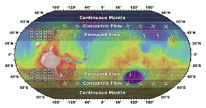
GOING WITH THE FLOW. The direction of flow for shallow subsurface ice falls into bands according to latitude. At latitudes higher than about 45°, the flow can go in any direction; below that latitude, flows occur just on pole-facing slopes. (Image taken from Figure 6 in the paper.)
A new study published by three Brown University planetary geologists argues that the orientation of ice flow features depends largely on the latitude of the location. Using the Context Camera (CTX) on the Mars Reconnaissance Orbiter, the scientists studied more than 10,000 images, and mapped flow features between 20° and 60° latitude in both northern and southern hemispheres of Mars.
Reporting in Icarus, the team led by James Dickson says that “poleward of about 40° to 45° in each hemisphere, ice accumulated regionally, regardless of slope orientation and specific microenvironments.” In these areas, where slopes were steep, the ice flowed downward; this flow produced concentric patterns seen today in the material filling the bottom of craters.
At latitudes closer to the equator than about 45°, they found that ice accumulated only on pole-facing slopes. In these locations, local microclimates became important, and flow features trend generally in a poleward direction. (And at latitudes lower than 25° there’s little or no evidence for flow because conditions were too warm for any ice to survive long enough to leave lasting geologic traces.)
Says the team, “These findings show that the most recent phase of significant ice-related flow on Mars is likely to have been focused in cold-traps on steep slopes in the mid-latitudes, and over all steep slopes at latitudes greater than 45° north and south.”


